|
| Click on any picture to expand all photos |
The trek had been on my bucket list
for at least six days. About a
week ago is when I’d read that Sacagawea’s son Jean-Baptiste (Pomp) Charbonneau
has spent eighteen years of the latter period of his life only twenty minutes
from my home.
Pomp and I had become fast friends over a summer that began
with a rugged drive to his resting place near the Owyhee River in Oregon,
including tracing of portions of Lewis and Clark’s Corps of Discovery
(1804-1806) and concluded with an exploration of Fort Clatsop, the Corp’s
western-most outpost at the mouth of the Columbia. There, I purchased a copy of Sacagawea’s Child by Susan Colby
In 1849 Tom Buckner and his partner
Ezekial Merritt, according to a legend recounted by Colby, came upon a gravel
bar on the Middle Fork of the American. There…
…they did see signs of
a great struggle, evidenced by tufts of hair from both a white man and an Indian. No bodies were found, but calcified
bone fragments unearthed nearby suggested to them that Indians may have
cremated and buried both protagonists.
The next day Buckner carved the words Murderers Bar into the
bark of a white elder growing nearby…
(pg 166)
 |
| Courtesy Tim Stewart |
By 1850…
…this new boomtown
boasted not only [an] inn run by Jean-Baptiste and [James] Beckwourth, but one
other inn, a blacksmith shop, plaza, fourteen saloons, and the Round Tent
saloon and gambling hall. (pg
167)
All of this being in my own backyard, I wanted to see
it. I wanted to walk for a moment
in Pomp’s footsteps.
I’d been to the Auburn Recreation Area
countless times and I’d hiked the old railroad grade to the quarry many times
as well. The route is level and
available only to foot traffic – both four and two – and bicyclists. From the grade river otters are often
spotted frolicking in the shallow waters of the American.
A mile and a half east, the old rail line ends at the
Mountain Quarries Mine.
 |
| Courtesy Tim Stewart |
Here concrete infrastructure rises out of the canyon wall
like some dark, European Gothic castle.
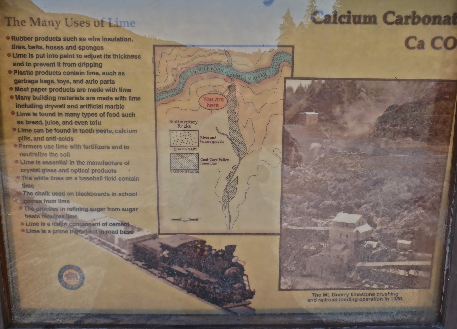
An informational sign tells us of the limestone that was
wrenched from the canyon’s gut…
…and while directional and distance signs tell us how far it
is to many points of interest along the Middle Fork, no mention is made of
Murderers Bar.
 |
| Can you spot the error? |
Recalling the topo map, we know that our goal is east less
than a half-mile, but the State Parks more than suggest the game trail along
the bank is not an option.
A wide route heads east, but bears away from the river and
causes us to gain elevation when we’d really rather stay closer to the
stream.
We hike past the opening
of a tunnel that was more likely used for gold than limestone extraction.
Soon we find ourselves on a broad slag pile made up of
crushed granite. Invasive,
non-native plants have found toehold.
Crossing the expanse of displaced fill, we peer over the rim
to where we feel Murderers Bar may one time have been.
Back in Pomp’s day, an apple was a nutritious treat. 160 years later, it is a tool that,
among other things, allows us to pin point our location. The blue dot on the screen tells us
where we are. Lewis and Clark should have been so well equipped. But then, I guess, we'd never have come to know "Pomp."
Distant enough from the state warning sign to fully recall
its content, we find a path leading us down the slope toward a wide bend in the
river.
Along the way, we find more non-native stuff. A concrete fence post…
…some scraps for metal nearly oxidized to oblivion, what
appears to be a coil bedspring (from Pomp and Jim’s inn?)…
 |
| Courtesy Tim Stewart |
…and some tiny, luscious grapes ready for our harvest, fit
for a Murderers Bar Cuvee, perhaps?
After a short scramble we come to a tumble of house sized
boulders. It is difficult to make
our way to river level without twisting an aging ankle.
At water’s edge where the current swings to the other side of
the canyon, a depositional flat – or bar – appears to be open for the primitive
development of Pomp Charbonneau’s day.
But we find no evidence of a carved white elder tree – its natural
life long over – nor any traces that the canvas and stick city ever existed,
however, because…
…Nature weighed in
with her own violence in the form of two disastrous floods. The first came in January [1850] when the river rose sixty feet, washing
away all the miners’ belongings and leaving them without shelter or food. This was followed by a flash flood in
September. (pg 167)
From the water’s edge, I look up the hill. Perhaps sixty feet above the river
rests that coil bedspring.
 |
| Courtesy Tim Stewart |
Not entirely certain that I’d walked
in Jean-Baptiste Charbonneau’s footsteps, the adventuresome side of me tried to
convince me that I had. After all,
he had to follow the American downstream when he finally turned his back on
Murderers Bar to settle in Auburn for his final 18 years. During the forty-minute hike back to
highway 49, I spent a little time reflecting on Pomp’s panoramic life and
realized I may have experienced an infinitesimal fraction of it this day.
And that feeling made this a good day.
Resource: Colby, Susan; Sacagawea’s Child: The Life and Times of
Jean-Baptiste Charbonneau. [University of Oklahoma Press (Norman) 2004].
Today’s Route: I-80 to Auburn, CA; south on SR 49 to confluence. Right turn at bridge. Park on either side of the highway although off-highway parking is
available two hundred yards south on the left side of the road. Fee.
© 2013
Church of the Open Road
Press
 Twenty-five years ago, I lived in
Sonora. Dad was visiting from
Chico. We’d entered the garage early
one evening after completing some outside chore. I reached to flip the interior light switch off and troublingly
noted, again, that the switch plate felt hot. With a flat-bladed screwdriver I’d been carrying, I removed
the plastic plate. Two bare, five
inch pigtails of wire were twisted together and crammed into the box around the
switch by the previous owner/builder.
Current coursing though those wires had blackened the inside of the
switch cover.
Twenty-five years ago, I lived in
Sonora. Dad was visiting from
Chico. We’d entered the garage early
one evening after completing some outside chore. I reached to flip the interior light switch off and troublingly
noted, again, that the switch plate felt hot. With a flat-bladed screwdriver I’d been carrying, I removed
the plastic plate. Two bare, five
inch pigtails of wire were twisted together and crammed into the box around the
switch by the previous owner/builder.
Current coursing though those wires had blackened the inside of the
switch cover.