Monday, September 29, 2014

THE TOYOTA 4-RUNNER (VINTAGE 2012)

A product review

A traveling buddy and fellow Church of the Open Road parishioner, John, proves that one needn’t own and tour on a motorcycle in order to be a Church of the Open Road believer.  His 2012 Toyota 4-Runner is a most able vehicle for exploration. 

Rugged and sophisticated, it eats up the old railroad grade of the Central Pacific in Utah…

…it creeps to the trailhead leading to the Von Schmidt marker in northeastern California…

…it doesn’t spook the wild horses in a remote Nevada desert…

…it whisks along any given US highway or Interstate at breakneck speed returning 22.5 miles per gallon…

…and it looks darned refined outside the Martin Hotel in Winnemucca while we’re inside enjoying a Basque dinner.

Equipped with GPS, we’ve been lost in the thing and we’ve always found our way back.


One of the last body-on-frame (truck-based) vehicles of its class, we did not use the ‘Runner to tear across a trackless landscape.  But both of us felt that in low-range, four-wheel drive, the vehicle would take us into and out of almost any small arroyo or washout to the other side where our desired rutted route would take up again.

The interior has more than enough room to ferry a couple of week’s worth of gear…

…or twenty four-one gallon cases of olive oil across several states – which we did as a part of our latest adventure.

In two extended adventures, each covering over 1500 miles of back country track and interstate slab, John’s 2012 Toyota 4-Runner (in the “Limited” trim level) proved both sturdy and rugged and quiet and smooth. 


Were  “the Church” not so enamored with two-wheeled motoring, the 4-Runner might become its vehicle of choice for exploring the vast reaches of the West as well as taking the Church Lady out on the town.

o0o

Note:  All photographs depict the vehicle on mapped and established – if rustic – roads and byways.  The Church of the Open Road does not sanction off-road sojourns across our delicate western landscape either on a motorcycle or in “a cage.”

© 2014
Church of the Open Road Press

Thursday, September 25, 2014

MORE STUFF BY THE SIDE OF THE ROAD

Central Nevada and Utah Edition

Countless narratives may pop up on a road trip: themes of history or commerce or antiquity or just foolishness.  Then there are the singular or small clusters of images that don’t fit a particular story until, when added together, they form the story itself.

Following is an album of those:

A sucker for old trucks and the stories they might tell, this one was spotted in Benton Hot Springs…

…as was this vehicle awaiting repair.

Venturing out into Nevada on US 6, we realize we are visiting the old west.  Cue a little Elmer Bernstein movie music.

East of Tonopah we visited the aging proving grounds where the “Right Stuff” boys cut their teeth…

…and viewed the aging hangars that once housed their rocket planes.


A day later, we are racing along a highway in Utah where the cut bank exposes seams of coal – coal the folks in Utah are eager to release…

Nearby, we witness what is referred to as “clean coal technology.”

It is wise to use caution when walking the streets of Price, Utah after dark.

Driving into Nine Mile Canyon, another old truck begs to be photographed…

…when what we’d really come to view was this:


Our visit to the Golden Spike National Historic Site was preceded by a stop at Ogden’s Utah State Railway Museum…

…where this narrow gauge locomotive was in the throes of restoration.

Its cab in a shop nearly finished after what the volunteer there claimed was about eleven years of 10 AM to 2 PM Saturday only work…  

…assuming the gang didn’t tank up on too much hot chocolate and coffee in the winter or beer in the summer.  The shop, we are told, is neither heated nor cooled.


Heading west along the old CP line, we come to an unexpected placard telling that the historic Wheeler Survey charted this area back in 1869.

A sandstone benchmark, nearly ground smooth by water and blowing sand bears George Wheelers mark.  Mysteriously, at this point, I am asked to make a mental note of the Wheeler Survey.  
Not a mile further, we arrive at the site of Kelton, Utah.  Little remains except for the railroad grade…

…and the cemetery.  (Not a bad place to spend eternity.  It certainly is quiet.)


Later, we seek the encampment at Palisade…

…where the Central Pacific crew forged line through a tricky canyon (40 years later, the Western Pacific chose the same route)…

…while living in hollowed out holes in the sandstone cliff buttressed by railroad timbers.


Elsewhere, some old signs – like some old trucks – beg to be photographed.


Transportation across the Basin and Range is a huge part of the country’s history.  First we walked it, then we spanned it with rails.  Later we flew, and in so doing dotted the landscape with navigational aides…

…and fuel carriers.  (This photograph is of the running board on a derelict and rusting fuel tanker trailer at a little used airport in Nevada.)


Wovoka was a man whose gentle power came from wisdom and faith.

We pay tribute to him at his resting place on the reservation near Smith, NV. 


Heading over Sonora Pass, west of the summit, we find a wide spot and it becomes clear why I was asked to remember the work of George Wheeler so many miles ago. 

Here, his team had carved a benchmark into a tree.  Its scar remains today.  Look carefully at what is inscribed in the tree's flesh.  (USGS - B M - 9205)

One comes to a number of realizations as the result of this little five-day sojourn into lost elements of America’s past.  Perhaps one of the most significant is this:  When flying along the interstate and seeing a tattered roadway or even just a pair of ruts heading through the sage and over a hill off toward a distant horizon, those tracks always lead somewhere. 

They lead to something, to some piece of history, to some gain or some loss.  Perhaps to a rancher’s feedlot, or a long played out mine, or a railroad construction gang’s camp, or a singular, lonely cabin dilapidated by wind and weather.  Or maybe just to a grand view of the west: a west that will be forgotten if we don’t, once in a while, explore some rustic route heading through the sage and over a distant hill.

o0o

Note:  Thanks here to fellow former educator and life-long geographer John who, with his trusty Toyota 4-Runner, guided this adventure across Central Nevada and Utah and back.


© 2014
Church of the Open Road Press

Wednesday, September 24, 2014

THE FORGOTTEN ARROWS OF THE EARLY AIR MAIL SERVICE


…from the Pre- to Recent History tour
of Central Nevada and Utah


In a short 75-year span from 1850 through the late 1920s, we’d gone from walking across the continent to flying across it.  While it once took months to get a letter from the gold fields in California back to the farm in Illinois, by 1925, it could be accomplished in 29 hours using the airmail service.

I suspect that this advanced delivery system came into being because after World War I there were many skilled pilots with equipment available and time on their hands.

Prior to the advent of radio wave communication, pilots could only rely on visual cues to get from place to place.   Thus, the early air service followed the railroad across the otherwise trackless deserts of the Basin and Range.

Across Utah and Nevada, remnants of some concrete arrows may be found.  These were coupled with forty-foot tall light beacons.  Each beacon had a gasoline generated power plant to supply the necessary electricity for  the light.  The illuminated arrows were placed across the desert to route the early flyboys of the mail service without requiring visual contact with the rail line.  Some remnants are accessible along the I-80 corridor.  Some are further afield.


Recently, we found a few.

This one is nicely preserved located within the I-80 right-of-way.

Others are being overtaken by weather and weeds.


Some required access through a gate.


This example shows an angle, as it is located at a point where pilots must change their heading.  The steel remnants used to anchor a forty-foot tall beacon.


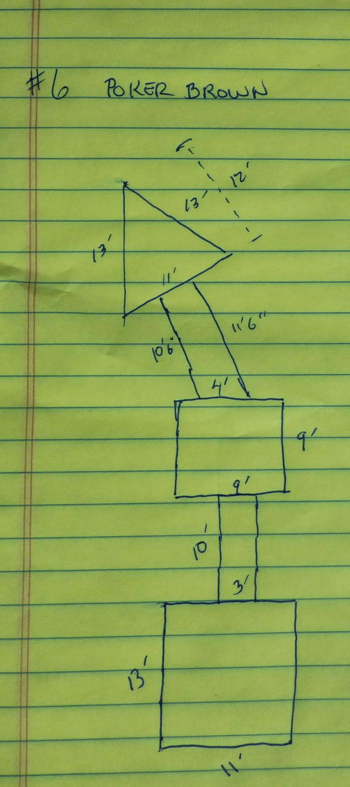
We sketched the thing and took measurements.

The arrows were constructed such that the point indicated the easterly direction.  The square at the opposite end indicated west and usually supported the gas-powered generator.  A square in the middle grounded the tower. 

We found that several of the old beacons arrows are located near where present-day cell phone or other communication service towers have been erected.


We found one example that was a challenge to get to but well worth the effort.

Silver Zone Pass is about ten miles west of Wendover, NV.  Hiking the service road seemed smarter that trying to drive up there.


Along the way, we enjoyed an increasingly panoramic view out toward the distant salt flats of Utah.


We find a nicely preserved example at the summit.


There is so much history to be found.  Some of it is granted significance because of its role in binding the continent and securing our nation like the Gold Spike National Historic Site.  Others, like these crumbling arrows may soon be lost to time and the elements, but they were no less important in binding together the nation in their day.


o0o

Notes: 

More information on the Beacon Arrows of the Early Air Mail Service can be found on-line.  Here’s one pretty good source: http://sometimes-interesting.com/2013/12/04/concrete-arrows-and-the-u-s-airmail-beacon-system/

The FAA publishes many pilot and flight specific manuals. http://www.faa.gov/air_traffic/flight_info/avn/flightinspection/fihistory/ Buried in a section called “Flight Inspection History “ we find: 

Drawing upon the methods of marine navigation, airway beacons were developed by the Post Office. The earliest lighting consisted both of rotating beacons and fixed course lights. The beacons were placed 10 miles apart and the 1,000-watt lamps were amplified by 24-inch parabolic mirrors into a beam exceeding one million candlepower. They were mounted onto 51-foot towers anchored on 70-foot long concrete-slab arrows, painted black with yellow outline for daytime identification and pointing along the airway. Course lights were also mounted on the light towers, projecting a 100,000 candlepower searchlight beam along the airway course and flashing a Morse-code number between one and nine that identified the individual beacon along a hundred mile segment of airway. Intermediate landing fields were spaced every 30 miles along an airway. These fields were primarily used for emergencies during poor weather or for mechanical difficulties. Pilots could locate these intermediate fields at night by green flashing lights installed on the nearest airway beacon.

The transcontinental segment between Chicago and Cheyenne was equipped with the beacons and nighttime service was begun on July 1, 1924. Additional segments were lit both east and west and the entire route east of Rock Springs, Wyoming, was lit by July 1925. Work continued to complete the lighting of the entire route, and the segment between Rock Springs and Salt Lake City was lit in 1926. The last segment over the California Sierras, with the most difficult terrain, was not completed until 1929 and was done by the new Aeronautics Branch of the Department of Commerce. As the airway was lit, the movement of airmail became a viable service. Even with only the eastern two-thirds of the route available for night flying, the mail could still move from San Francisco to New York in 29 hours, versus 72 hours for the routine rail service. By the mid-1920s, airmail was the greatest success story of commercial aviation and became the foundation upon which the passenger airlines were built.

Epilogue

“Oh, yeah, I knew about those,” my 92-year old mother said while sitting in her rocker at the independent living home.  I’d just informed her that I’d be seeking some long forgotten concrete arrows that were once used by airmail pilots to direct their flights across the Utah and Nevada desert.  “Hap (her father) used them when he flew the air mail after the war.”

“How come you never told me?”

“There’s a lot I never told you…”


Edgar W. “Hap” Bagnell was an “Early Bird” having piloted powered aircraft prior to December 17, 1916: http://www.earlyaviators.com/ebagnell.htm.  I was not aware that’d he’d flown airmail after World War I until I mentioned the arrows to Mom.


© 2014
Church of the Open Road Press