Not on California State Route 45
The Sacramento River is a silent,
strong workhorse. The river
sources itself off the flanks of Mount Shasta, way up north in Siskiyou
County. It collects minerals and
vegetable matter and, not withstanding the recent appearance of Shasta Dam,
transports its load south to deposit throughout the broad Sacramento
Valley. The rich loam on the
valley floor provides the best growing anywhere in the world.

Roads in the valley are generally straight, providing no
real challenge for the motorcycle rider.
The exceptions are those routes that trace the river’s banks or
levees. State Route 45’s seventy
miles between Knight’s Landing and Hamilton City (and some neighboring
secondary roads) offer a pleasing respite from I-5 or SR 99 with sweeping turns
and nice views of the workhorse.
Such then, was my plan. Except that I started on those secondary roads and never
actually got to 45.

The Knight’s Landing Bridge is a
rather unadorned crossing of the Sacramento River. The bridge’s spray painted label looks as if it were an
afterthought. Walking across the
span, one is afforded a nice view up the river. Just below, a resident lives in a houseboat that rises and
falls with the rhythms of the river.
Not bad.

Immediately across the bridge,
Cranmore Road heads west and follows the river’s winding levee.

A once-near-classic Cris-Craft, having
seen far better days, serves as the landmark for the turn.

Cranmore Road is not well maintained. The pavement is rough enough to not
invite spirited use of the throttle.
But that’s okay. Views
along the languid river are beautiful.
It is said that in Africa, toward the end of their lives,
elephants find special places to greet eternity. Elephant graveyards, they’re known as.

In America, the same might be said for
Studebakers. This is the second of
such hollowed places I’ve run across in my travels.


In the shadows of the Sutter Buttes…

…one finds many implement graveyards scattered here and there…

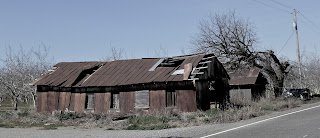
…and barns of many different construction materials like
this corrugated metal building just waiting for the next big wind to blow it
into the river.

But, with all that old stuff, it is interesting to find modern big-scale farming deploying some land for solar power collection. I passed three of these solar farms this day.


Crossing the river wasn't always so easy or convenient. As recently as the
1960s, cable ferries at Ord Bend and Princeton shuttled farm vehicles and
residents from one side to the other. Dad used to drive us out to the river in the old '54 Ford wagon just to ride
‘em.
 I stumbled across the remains
of the Princeton Ferry rusting and rotting just above stream level. And atop the levee just behind the hulk? That's State Route 45: the road not taken this day.
I stumbled across the remains
of the Princeton Ferry rusting and rotting just above stream level. And atop the levee just behind the hulk? That's State Route 45: the road not taken this day.


The old bridge is now gone and here is the replacement:

Next trip: Looks as if I’ll need to rocket up to Hamilton City planning
to take a day exploring the west side of the river on and off SR 45.

Return: West on 32 to Hamilton City; south on
45 to Knight’s Landing; OR east on 32 to Chico; south on SR 99.
© 2013
Church of the Open Road Press
No comments:
Post a Comment