Part 2 of 2
To recap: The Church of the Open Road has been kicked out of the house while Mrs. Church of the Open Road enjoys an annual reunion with former teaching colleagues. The following recounts day two of exile.
The dawn, this morning, came up like thunder.

Last night, I did a little research using this source: https://pubs.usgs.gov/of/2005/1127/chapter9.pdf?fbclid=IwAR05HiP_9y3bDp80H7g_LhM-tUsS0tvk_cD76PuPDsLHJy-BSdQr3iWeQQE and was eager to get started.
I’d learned that evidence to the conflict between the Pacific Plate and the North American Plate could be seen opposite the run-aground fishing vessel behind the Inverness Store.
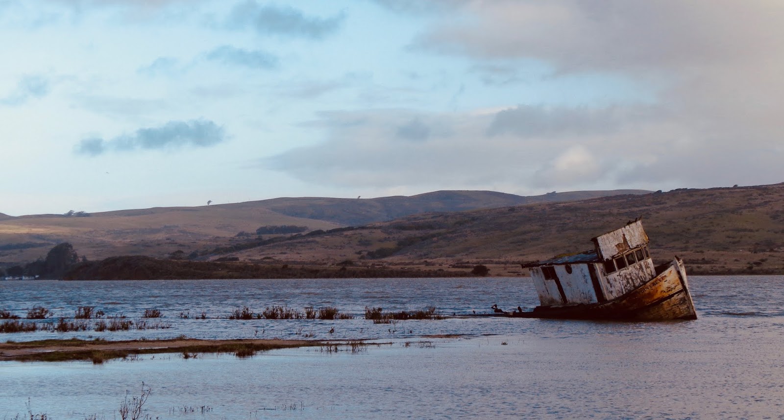
The black wedge on the opposite Tomales Bay shoreline to the left of the boat is an uplifted marine terrace near the trace of the San Andreas fault. Eureka!

I also learned that the Salinian Granite found near Tomales Point is unlike any rock found on the other side of the bay; but it is geo-genetically (my word, not that of a geologist of any repute) geo-genetically identical to the granite found on the eastern side of the fault down in the Salinas Valley some 140 miles away. At movement the speed of fingernail growth, how long did that take? And – some food for future thought – how long before Los Angeles, California on the Pacific Plate will pull alongside San Francisco which is on the North American? And will the two rival cities be able to work out their differences before that happens?
The Tomales Point Trail is groomed for three miles. The 1.7 mile to the actual point is not maintained.

I wouldn’t make it that far this day. Cool temperatures – 45 degrees, according to the Subaru, high winds – 35 to 40 mph sayeth the weatherman on channel 5, intermittent rain and slicing hail along with a gimpy knee would curtail my expedition at about mile 2.5.
For moments the air was clear and sunny, but the distant clouds were foreboding and racing this way.

I wanted to get as far as the Tule Elk Reserve…

…and I did.

Then I wanted to get as far as a view of the mouth of Tomales Bay.

Did that, too. Across the opening a sand spit led to the little community of Dillon Beach, a place I would later visit to catch a view back this way.
Back-tracking, the wind picked up and birdshot sized hail pelted. The circumstance didn’t seem to bother one young bull.

And, as quickly as the squall roared in, it passed. The view to north looked almost the same as it had two hours before.

The trailhead parking area is shared by the historic Pierce Ranch complex. The lush pasturelands of the Point Reyes Seashore have long been held by ranching and dairy interests.
From a distance it’s all quite bucolic.

Pierce Ranch no longer operates, but the National Park Service has maintained the site in a state of arrested decay.

Barns and bunks, implements and even a school house are there to wander by and imagine what life might have been like before so much pavement and progress.
A raven stands guard as I tour the grounds. Hitchcock’s Bodega, I remind myself, is only ten or twelve miles distant the way the crow flies; and this was a pretty good-sized crow.

A primitive hinge caught my attention – simply a two-by-eight (or so) bored through with a hole large enough to accept the whittle stub of a gate swing. The bottom of the gate swing would be stuck in the ground to rot and then be replaced.

Soon it became economically feasible to build a blacksmith shop for this and other ranching necessities.
Tomales Bay State Park (fee required, unlike the rest of the area) shares a small portion of the region. Sections are on both sides of the bay, therefore both sides of the rift zone.

The peninsular portion includes a nice beach where kayaks can be rented, and a well-appointed nature trail recalling the living arrangements of the Coastal Miwok.

The half-mile path leads under this rather gangly looking coastal life oak…

…and out to a semi-remote beach…

…where replica Miwok bark huts which appear quite similar to those found in the Sierra around Pinecrest Lake (Tuolumne County).

A Great Egret (yellow bill, black legs – as opposed to a Snowy Egret: black bill, yellow/black legs) poses in the creek.

The morning of the third day, I was called to return from exile. Along the way, I wheel into the coast village Dillon Beach to get a view or two of Tomales Point from the North American plate.

From a bit greater distance, the spring grasses catching the mid-morning sun show the graceful lay of the land across the inlet.

And from Bodega Head, perhaps a dozen miles further north, I stand on the “furthest north existence of Salinian Granite” and snap a farewell photo of the San Andreas Rift Zone as it is found in Marin County.

The adventure has been a good one. If not actually experiencing – but, at least, imagining – the dynamics of a continually evolving landscape helps place me in time. I come away with a deeper appreciation for the beauty of our coastal environment and the science that helps us to understand.
And I look forward to Mrs. C.O.T.O.R’s next “girl’s weekend.”
© 2019
Church of the Open Road Press
Beautiful views. The vastness of the Pacific always is a little awe inspiring to me. I am a little jealous of the blue sky you found, squalls rolling in and all.
ReplyDelete