Showing posts with label Gold Country - Monterey Coast Loop. Show all posts

Thursday, April 14, 2011

GOLD COUNTRY – MONTEREY COAST LOOP – EPILOGUE: RIDING THROUGH AN APRIL BLIZZARD


Part 4 of a 3-part series.

Sometimes the road just gets to be an obnoxious partner. And no matter how hard you try, you simply can’t seem to find harmony. It happens. And when it does, it doesn’t make sense to push things.

Eric Trow
“Riding Well” column in Rider Magazine, May 2011.


THE SECOND WEEK IN APRIL is considered a pretty “sure thing” as far as riding weather goes. But this year, abundant rains fell in January and March pushing the beginning of spring back a few weeks. As mentioned earlier, the weather gods fooled with our original plan to explore the Redwood country up north. And, Thursday, riding from Monterey to San Francisco seemed like a giant game of cat and mouse, one where the cat came armed with thunder, lightning and huge pellets of rain.

It wasn’t until after my riding partner and I parted north of San Rafael that my luck ran out. Heading east from Napa over the familiar route 121/128 toward Winters, the climb out of the valley carried me under a cloud that was blacker than Simon Legree’s hat.

(c) Missouri University of Science and Technology

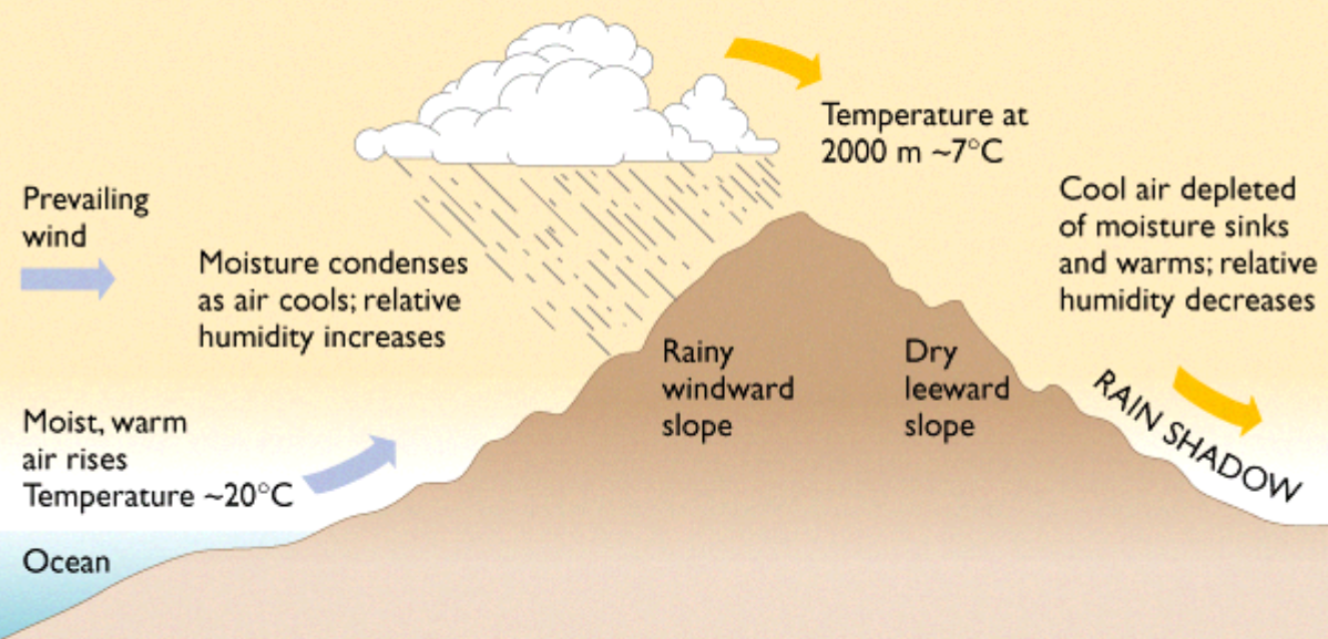
Oragraphic precipitation occurs when moist air is pushed up and over ridges of mountains. Figure that for every 1000 feet in elevation gain, the temperature drops about three degrees. Water droplets form around dust particles. Gravity pulls them earthward. But an uplift within the cloud grabs these tiny droplets and yanks them back skyward.

nc-climate.ncsu.edu
On their journey, more droplets attach. They gain weight and begin to fall until again captured by the uplift. As the physics intensify, the drop rises higher into the atmosphere where super-cold air turns it to ice. It falls and rises, gains layers, falls and rises, falls and rises until its mass becomes too great for the rising column of air. At this point, it is a pellet-like hailstone. It breaches the bottom of the cloud mass and falls to earth.


ABOUT THIS TIME, I come tooling along on the BMW. I’m wearing the proper gear for wet weather, but my thick, waterproof gloves fail to keep my digits nimble. And the layer of slushy ball bearings tends to counteract any tractable qualities of my relatively fresh Metzler Tourance tires.

In moments, the landscape turns white and the inside of my helmet fogs up. I crack the Shoei’s face shield a bit and the fog disappears, but I have to use the index finger of my clutch hand to wipe the sleet off the outside. I slow. The fellow in the Ford pickup I’d raced by only a mile or two back, is now just behind me. At the slightest wide spot, I let him pass. He must be laughing. The day before yesterday, I’d taken this at forty-five miles per hour in fourth; today I’m doing fifteen in first and second. There is no place to pull over and wait this thing out; no shelter from the squall. Twenty-five miles ahead is the Putah Creek Café which harbors hot coffee and closed about thirty minutes ago. I press on-ward thinking about the hot-buttered rum I shall concoct once I arrive home. If I arrive home.

As quickly as I entered it, I passed under and through it. The road turns from icy pebbles to wet pavement, then to dry. I’d outrun - well, out-crept - the storm.

Google Images
Just as I start to grin and congratulate myself on the steeliness of my resolve (read: cojones), a young man on a sport-style “rice rocket” blasts toward me. He is wearing jeans, a t-shirt and a full-face helmet. No leather. No mesh. No insulation. No brains? He gives me the requisite low-five – the signature wave of sport bikers – and races into the storm.

Either I’ll read about him in tomorrow’s paper or his resolve is a hell of a lot steelier than my own.

***

RESOURCES:

Eric Trow’s Motorcycle Safety website: www.stayinsafe.com

Rider Magazine is published for folks who tend to keep both wheels on the ground. It is available at newsstands and by subscription: http://www.ridermagazine.com/

© 2011
Church of the Open Road Press

Wednesday, April 13, 2011

GOLD COUNTRY – MONTEREY COAST LOOP – DAY 3: MONTEREY TO SAN RAFAEL

Part 3 of a 3-part series.


The rain may never fall till after sundown.
By eight, the morning fog must disappear.
In short, there's simply not
A more congenial spot
For happily-ever-aftering than here
In Camelot.

- Alan Jay Lerner, 1960


THE POST-DUSK STROLL from Abalonetti’s on the wharf to our digs at the downtown Monterey Best Western was cool bordering on cold. Clams and linguine were nicely complemented by a local Sauv Blanc, but our concerns rested with a weather report to which we’d tuned prior to headed out for dinner. A thin layer of cloud cover masked any stars and only a gossamer-like thread of new moon sliver could be seen through the gathering overcast. We talked about the previous two sunny days and agreed that we were due for some bad weather luck.

The next morning, the weather reporter for the local television station stood before a telestrator upon which fluorescent green Doppler dots swept inland from the Pacific. “Expect unsettled weather throughout the morning and into the afternoon.” We engaged in a misty walk to a breakfast place noting from the wet pavement and running gutters that it must have “rained like hell” last night. But, by the time we returned to the Best Western, packed and saddled, the sky was as azure as a gemstone.

A bullet had been dodged. Or had it?


HIGHWAY 1 NORTH of Monterey is a freeway. Without yesterday’s crosswinds, the ride was smooth. Above Castroville the road pares down to two lanes and the cruise through the fertile coast valley is pleasant, if cool.

usridernews.com
Our plan always is to take a break an hour or so in to every day and every hour or so there after. As luck would have it, Santa Cruz boasts Moto Italiano, a Ducati, Moto Guzzi, Aprilia and sweet little scooter shop just off the highway 1. A good bike shop always makes for a nice stop. On a relatively slow Thursday morning, sales guy Scott eagerly shares about the new-last-year Multi-Strada, a Ducati designed to perform favorably with our BMWs, all the while looking as dazzling as, say, Anita Caprioli. Randy straddled a red one, gripped the throttle and twisted.
Piaggio SpA
Meanwhile, I found a brand new three-year-old Moto Guzzi Breva that I felt would complement my GSA should I decide I needed a stable of motorcycles. (Save that one for me, will ya Scott?)


An hour quickly passed and once back on the highway, the specter of “unsettled weather” appeared on the horizon. Coursing north, an angry, black billow sat off shore. Beneath it, the Pacific’s horizon was lost in a gray, streaked downpour.

The bottom had, indeed, fallen out. Highway 1’s west-northwest cant seemed to be driving us directly into its core. Progressing toward Half Moon Bay, we couldn’t help but alternately eye the road and eye the incoming storm. The further north we ran, however, the further toward due west the thing seemed to rest, by the time an hour has elapsed, the beast was behind us. We stopped for photos.

Dodged another one.


ONE THING I’D VOWED never to do was to operate a motorcycle in the city of San Francisco. Clutches. Hills. Buses. Trolley tracks. Wacko drivers who squeeze through intersections on the red. But after a chilly detour up 35 and over to 101 – past the famed sport bike rider hangout Alice’s Restaurant, the temperature had dipped to 38 – we found ourselves heading north through the Sunset, across Golden Gate Park and over the bridge.

About mid-way, with a slight wind buffeting the motorcycle, I glanced at the waters below. I thought back to the gold country we visited as recently as yesterday – of the towns, the homesteads, placer mines and coyote holes – the evidentiary clues that history had happened. I thought of the people that changed California from pastoral to powerhouse and realized that a hundred and sixty years back, fully half of them sailed through the strait I was now crossing. The diversity we’d experienced, at once, seemed interconnected.

The three-day trip had come full-circle. We stopped at the north end for a view of the city and for farewells. Riding buddy Randy would return to Santa Rosa to turn in the GS although I know he’d just have soon continued north to Seattle on it. I would head across state route 37 to Sonoma, Napa, Berryessa and home. A grand time was had by both of us and the only thing we missed was the storm.

***


Resources:

Moto Italiano Santa Cruz: http://www.motoitaliano.com/

Again: Adventure Touring Santa Rosa: www.advtouring.com/

Anita Caprioli: http://www.anitacaprioli.it/


© 2011
Church of the Open Road Press

Tuesday, April 12, 2011

GOLD COUNTRY – MONTEREY COAST LOOP – DAY 2: SONORA TO MONTEREY

Part 2 of a 3-part series.

CO-RIDER AND GOOD BUDDY RANDY BOEK comes from the private sector. Me? Public schools administration: 34 years. In real life, Randy is a leadership development expert. We’ve known each other for well over thirty-five years. Honest with each other to a fault, he lets me know when I’m full of it and, in return, I agree. Over dinner at the Diamondback Grill, we talked about leadership and both the private and public sector’s current dearth thereof. Talking about the day’s riding would have been much more satisfying. The conversation on the evening of the second day would be much different.


WHEN I LIVED IN TUOLUMNE COUNTY twenty years back, Washington Street boasted at least three breakfast joints, The Miner’s Shack, Wilma’s (nee: the Europa) and a place on the ground floor of the Sonora Inn. As things evolve, breakfast seems to no longer be the most important meal of the day and pastries at The Gunn House would have to suffice.

At the crack of 9:00 AM we boarded the BMWs. Choosing a non-state highway route, we wound through springtime on Lime Kiln, Algerine, Twist (aptly named) and Jacksonville Roads. Grasses approached knee depth. Pasturelands were quiet grazed by cattle, sheep, goats and llamas. The cool, dense morning was heavily ladened with the aroma of these livestock. It felt like country. Good country. A scenic overlook at Don Pedro reservoir invited a stop.

(click to expand)
I’ve driven 49 from Sonora to Mariposa in an automobile. It is, at best, a chore. On the bikes it is a carnival. Beyond the San Francisco deeded water units at Moccasin, route 49 continues to snake through foothills for the entire southern length of the Mother Lode. Riding this ribbon of pavement is much like a dance with one delightful move inviting another and another. You hope the music never stops. Vistas to the west take in the broad central valley. To the east, on occasion, we glimpse the high Sierra east of Yosemite.

Gold seekers from throughout the world flocked to the narrow band of rolling hills from 1849 through the mid fifties and beyond. They built towns of brick and timber, many of which have returned to dust, some of which are mere place names and some of which still stand as reminders.

Arriving at Coulterville, we dismount for a close up look at the remnants of our heritage. A massive wisteria climbs through the second story porch at the Hotel Jeffrey, its trunk bigger in diameter than the posts supporting the veranda.

The streetscape includes the abandoned brick general store with evidence of its conversion to electricity. Our heels echo on the boardwalk that may have been first constructed at a time when roads turned from dust to mud in a matter of hours.

Placed at one end of town is Whistling Billy, a narrow gauge tank side engine, workhorse from the mining era through the lumbering era. An example of which was recently discovered up north within the basin of a drained Butt Lake (Plumas County) when the dam was retrofitted for seismic safety.

Mariposa C of C
49 slinks along creek sides, over ridges, through pastures and gentlemen farms. John C. Fremont trooped this way sometime back. Someone named Bagby got a town. Trabucco means firearm. Pendola, we’re not sure. Ophir’s named after the Biblical land of gold.A bootjack was an early implement for boot removal but the town was named after the v-shaped lay of the road or the streams in the area. Mariposa has to do with butterflies. And Oakhurst?

Oakhurst is at the southern foot of highway 49. On a whim, we skimmed along the ridge tops the route takes for its final nineteen miles. I hoped to park the bike under the marker reading California 49 with a rectangular sign reading “end.” There wasn’t one. There was that typical mix of brick and board buildings harkening back a century and a half. We lunched in Coarse Gold.


THE AFTERNOON found us racing westward through the foothills into the orchard plains of the San Joaquin Valley. Almonds. Pistachios. Citrus. And wind. Between Los Banos (so named “the baths” for pools in the area, not “the toilet”) at the east side of the Coast Range, a nasty north wind blew across our track. At highway speeds on route 152, it felt as if at any moment we could be plucked from one lane and deposited in the next. Or across the median. Up through the San Luis Reservoir, each time the road turned or crested a hill, we had to be ready to correct for windblast. Once over Pacheco Pass, the winds abated. Past Casa de Fruita, we pulled over swearing in general, but also swearing specifically that neither of us wanted to ride through such conditions again.

Over the ridges, skirting biker Mecca Hollister, we routed through San Juan Bautista, where Patty Reid’s doll resides at the state park. Names on the landscape are more Hispanic. The hills rolling, green and pastoral. It is understandable why Fr. Serra and his ilk found this land of milk and honey fit for civilizing. If one didn’t save a soul on a particular day, at least the weather would be pleasant.

Miles further, we connected with State Route 1 and, like Fremont a hundred and seventy years back, aimed for Monterey. A sunny spring day had warmed the coastal plain and the air mass above it lightened and rose. Furiously rushing in would be the cold, bitter air from over the Pacific. The winds of the San Joaquin became mere child’s play as we batted down 1, gripping the bike’s saddles in a manner we had not assumed our butts could actually grip, peppered by blowing sand, and greatly concerned that the next gust would blow us into the path of a passing Freightliner.

Google Images
We did not talk leadership at Abalonetti’s on the wharf that evening.


 ***


RESOURCES:

Gudde, Erwin G, California Place Names – the Origin and Etymology of Current Geographical Names, University of California Press, 1949, 1960, 1969, 1998.

Randy Boek (rhymes with “heck” or “wreck”) is a business consultant. He works in leadership development. He believes in the power of people working together toward clearly articulated and commonly understood goals. While much of his focus is on private sector success, there is much that he has to offer leaders in education and other public endeavors. For more information, see http://www.route2results.com/ His insightful blog may be found at http://randyboek.wordpress.com/

Sunday, April 10, 2011

GOLD COUNTRY – MONTEREY COAST LOOP – DAY 1: SONOMA TO SONORA

Part 1 of a 3-part series.

AS A YOUNG BOY, flabbergasting my mother, I walked down to Chico Book and Stationery and ordered a copy of Remi Nadeau’s Ghost Towns and Mining Camps of California. I was, perhaps, eight. For days – well evenings – I poured over the book’s photographs and stories of life in the gold country of California – the corridor along state route 49 – and dreamed of one day buying a practical car (at the time, either a Jeep Wagoneer or a VW Combi Bus) and spending the rest of my life camping out like a 49er. In the fifty intervening years, I have traveled most of 49, achieving its northern terminus at Vinton (Plumas County), but never to its southern end at Oakhurst. Little did I know I’d make it this trip.

Our plan had been to meet in Santa Rosa and travel up US 101 to Eureka, using the Eureka Inn as a home base from which to explore 299 east to Redding and return on the most glorious state route 36 west from Red Bluff. But the weather gods frowned on this, sliding a hillside across 101 north of Garberville and prompting us to scrub those plans for no plans in particular.


(c) iktome.com
CHURCH OF THE OPEN ROAD original parishioner, Randy Boek, hailing from Washington State reserved a 2010 BMW R1200 GS from Adventure Touring in Santa Rosa, California. Proprietor Mike Bongiovanni meticulously maintains his rental fleet of GSes and when Randy and I met up at the plaza in Sonoma, it was immediately evident that we were in for a good time.

I’d ridden from home in the Sacramento area, stopping in Winters at the Putah Creek Café for breakfast – if you can find a better breakfast sausage anywhere on the planet, please contact “the church” and let us know; we doubt if you can – and pausing at the Monticello Dam to see if the waters of Lake Berryessa had eclipsed the Glory Hole. They hadn’t.


© 2011 Suisun Valley
WE TRACED MY ROUTE from Sonoma to Napa on 121. Nine miles east we slipped into the bucolic Wooden and Suisun Valleys, rustic land of wineries, local farmers’ markets, bergs and hiking trails. Often overlooked by those traveling I-80 to or from “the City,” this little part in the Coast Range offers a view back to slower times where drivers pull over to allow passing, quite possibly, locals know one another by first name. In the highest reaches, every flat half-acre homes a vineyard; and as we approach Fairfield, row upon row of varietals are just in bud for the new growing season.

Crossing I-80, we rode along state route 12 toward the Delta. A pause at Rio Linda. The public restrooms are barricaded by steel gates slipped into concrete dikes. Silt rests upon the river-side of these arrangements, reminding us that flood stage means things really, well, flood, in these parts – as recently as last week.

We devised a simple plan to cross the valley floor on state route 12, catch state route 49 at San Andreas and spend the night in Sonora. Phone reservations are made at the Gunn House there.

Not far east of Lodi, route 12 begins a graceful waltz through the foothills. The spring grass is tall. Blue gilia and lupine decorate the berm and I recall that an edible bulb lives at the base of the former.

(c) westernmininghistory.com
San Andreas is the first of many towns along the Golden Chain Highway that we will pass through. Each will have brick buildings with aged and cracking plaster exteriors revealing, well, brick buildings. Highway 49 bypasses the oldest part of San Andreas, but the “business route” steers one through a town with one foot secured by history.

I know this section of 49 well, having once worked a mining claim near “Mark Twain’s (rebuilt) Cabin,” and later having served in education in both Jamestown and Sonora. At the time I drove an ’83 R65 “airhead” BMW, a bike for which these roads were specifically engineered. 49 sweeps into and out of the canyons of the Mokelumne, Stanislaus Rivers and several smaller creeks. The sun dips below the ridgeline south of Angels Camp. The ride past Columbia into Sonora turns cool.

(c) Gunn House Hotel
Our room at the Gunn House is comfortable, affordable and historic. An evening there with my wife would have been far preferable to an evening there with my riding brother, but oh well. We hiked down to the Diamondback Grill for some oriental ribs and local wine, ran across some friends from long ago, then returned to the hostelry and turn in. All in all, a most excellent first day.

***

Downtown Sonora: circa a while ago.  Source: Google Images
NOTES: Owing to the fact that we dropped the ball on stopping for pictures, many images included in these posts are swiped from Google. They are noted as Google Images, but may be the copyrighted work of other photographers, artists, sojourners, or others in league with ne’er-do-wells. When possible, I will credit the photographer or their URL and regret my inability to do so in every case. That said, the pictures are used for illustrative purposes only. The Church of the Open Road profits in no monetary sense from their use.

I recently lost track of my old copy of Remi Nadeau's Ghost Towns and Mining Camps.  I must locate it.


RESOURCES:

Adventure Touring Santa Rosa: www.advtouring.com/ Mike’s main business involves offering guided tours of some of the best roads found anywhere. Repeat: Anywhere! But Mike rents maintained, state of the art BMW GSes when they are not being used on a tour. Randy’s bike was flawless.

The Putah Creek Café http://putahcreekcafe.com was recently featured in the Food Network’s Diners, Dives and Drive-ins. Fine small-town atmosphere, offering killer burgers for lunch and, oh, yes, that house-made breakfast sausage.

The Diamondback Grill www.thediamondbackgrill.com/ had just opened up when I relocated from Sonora, but I remembered the ribs. They have moved across Washington Street from their original location and have added greatly to their menu and wine list. This is a must-stop-at eatery.

The Gunn House www.gunnhousehotel.com/ is conveniently located on Washington Street near restaurants, watering holes and shopping. Its ambience takes one back a century and a half. Nice rooms, nice staff, nice price.


© 2011
Church of the Open Road Press