Showing posts with label US 395. Show all posts

Sunday, August 19, 2018

MOTHER NATURE: HER DISPLEASURE AND HER LOVE

notes from an eastern Oregon road trip - part 4 of 4

Over a period of eight or ten days, I'd spent many hours on Enrico, the Yamaha, touring much of Northern California and Eastern Oregon. Sadly, with the exception of a couple of hours ringing the summit at Crater Lake, most of the ride had been completed under hazy skies and, in some places thick, settling, eyeball-irritating smoke. Stands of dead timber cover acres and acres of California and Oregon forest lands. Homes and cabins that once were, are no longer.

Clearly, Mother Nature is displeased with us. And not without cause, I would guess. Our clever industriousness over a little more than a century has brought many conveniences – fossil-fuel-guzzling automobile travel, coal-fired electric energy, and honey-bee-eradicating mega-farm food production. Many of those things we now depend upon and once thought were relatively cheap come at a cost: a delayed one. 

The bill is coming due. 

On a haze-shrouded Thursday, after stopping for lunch at the Squeeze In in John Day, Oregon, I drenched my cooling vest in a creek out behind the cafĂ© and slipped it on under my vented riding jacket. At speed, this garment will act like a swamp cooler making the smoky mid-day 98-degree heat much more tolerable. I mounted up and headed down US 395 toward my night-stop in Burns.

Climbing out of a canyon and onto the prairied tablelands around Seneca it turns out I may not have needed that trip to the creek. The sky suddenly turned dark and the temperature dropped about fifteen degrees. Clouds had gathered over this high desert: clouds eager to relieve their burden. Soon my riding suit was being peppered with marble-sized raindrops that flattened the sage and grain fields on either side of my route. In those moments, as the raindrops danced across the pavement in front of me, the air bloomed with a fragrance the folks at Chanel of Paris can only dream about. Sweet. Thick. Pure. Refreshing. Reassuring.

A gift, perhaps?

Twenty minutes of riding through the cloudburst and the cleansing it carried convinced me that while Mother Nature may be angry at us, she still loves us a lot.

That's how mothers are.
© 2018
Church of the Open Road Press

Saturday, April 21, 2018

EAST SIDE OF THE SIERRA SCENES

… not so Californee-ized as California …

From Inyo to Modoc, something about the east side of the Sierra Cascade is different.  Perhaps those great mountains that keep out the rain keep out something else as well.  Slower in pace than the rest of California – a bit lower in price, too – travelling along US 395 from Ridgecrest to Alturas provides a peek back at times past.  


In early April, we travelled the southern portion from Kramer Junction (with CA 58) to Minden in Nevada’s Carson Valley.


I – Alabama Hills

Outside of Lone Pine, on the way to the trailhead at Whitney Portal – closed in April due to snow – one passes the Alabama Hills.  


A great display of wind-rounded granite or sandstone, one could be excused for thinking Hop-a-long Cassidy might be about to round a bend in the trail, because this is where they filmed him doing so.


John Wayne, Duncan Reynaldo, Gary Cooper and countless others as well.

A museum nearby recounts the Hollywood history of the area and roads and trails allow visitors to believe, for a time, that they are extras if not in a western, then an ad for a Chevy or a Ford truck or a Mazda automobile rooster-tailing dust across the desert.


Watch out!  Perhaps there’s a sidewinder hiding out behind this. (Probably not.  Outside of Sacramenta, they ain't no sidewinders in Californi-ee. - Walter Brennan as a renegade sourdough in a John Ford Western, shot in these parts.)


The April weather turns quickly and the clouds present a real-life drama without the help of lighting or sound technicians.  


A half-day spent here is a half-day well spent.


II – Manzanar “Relocation Center”

I’d been to Manzanar before. (A link to that visit follows this post.)  In August of 2010, the heat seemed unbearable and it was easy to feel how miserable life was for fellow citizens whose only crime was being born with a different color of skin or a different shape of eye.


In April of this year, a nasty north wind blew rain drops horizontally across the landscape peppering us like birdshot and chilling us to the bone.  


The gale beat at the tar paper roofing and siding. Residents were never far from the fierce elements of springtime.  I don’t want to imagine winter.

The National Park Service has reconstructed a few of the crude dormitories, cookhouses and latrines.


And in the substantial gymnasium, built by the hands of those interred, displays speak to life in this high desert and of the misguided thinking that prompted the creation of this and ten other remote and inhospitable places.


As a tiny girl, a one-time colleague of mine spent time at Poston in Arizona.  At age three, it is hard for me to believe that she was ever a threat to the Republic.


III – Bristlecone Pine Forest

When my computer malfunctions, when the tool becomes and obstacle to getting work done, I often slip into use of my second language – profanity – until the problem is resolved or I’ve tossed the thing out the window.  My traveling partner, I came to find out, has a similar reaction to steep, narrow, windy roads without guardrails.

Such is the road to the Ancient Bristlecone Pine Forest.


I stopped for few pictures.


The Visitor’s Center, some 28 miles east of US 395, offers interpretive exhibits when open (it wasn’t, yet) and a couple of easily accessed trials (if you discount the drive up there) to the oldest living things on earth.


Humbling indeed.  Our visit was truncated by the anticipation of the road back down the mountain.  


On my list is a revisit on Enrico, the Yamaha, affording me more time to embrace the truly timeless nature of… …nature.


IV – June Lake Loop

A side trip on the June Lake Loop might be preferable to rocketing up 395.  The loop swings west to the foot of the precipitous tilted fault-block uplift that forms the east side of the Sierra.  Summer homes and ski cabins cluster in the tamarack pines along the edges of high mountain lakes.

Snow melt pours over rocky ledges…


…filling those lakes with pristine water and perfect reflections.


You can’t help but come away with a crick in your neck after looking skyward at the jagged aretes and peaks of the High Sierra: So near and yet so far.


V – Parting Shot

We chose not to visit Mammoth this trip having been advised that is may be a bit too corporatized for its own good.  Fine winter skiing is offered but in the transition from being an out-of-the-way secret to a destination resort, some have suggested Mammoth may have lost a bit of its charm.  The same might be said of much of Tahoe, further north.

I suspect I may have inherited some sort of a latent desert rat gene from Dad.


Thoughts of mountains and valleys and sage and clouds and a little thunder – rather than speedboats and casinos – are all I need to urge me to return to the East Side.


o0o

Notes and Resources:

Along with your DeLorme’s California Atlas and Gazetteeryou should

Read:  The Land of Little Rain by Mary Austin. 1903. Widely available, Mary Austin writes of the area in a beautifully lyrical fashion, providing the reader with a deep view of the geography, natural history and culture that have shaped and are still shaping this Land of Little Rain.  (My copy, Penguin 1988, has an introduction penned by Edward Abbey making the volume a special treat.)

Purchase: At the bookstore in Bishop or, better yet, prior to departure get: Guide to Highway 395: Los Angeles to Reno by Ginny Clark.  Western Trails Publications, P O Box 2485, Lake Havasu, AZ, 86405. Revised 2013. $20.  A few typos but a lot of tidbits of history that’ll make you want to take – rather than pass by – that non-descript turn off.

Pick up: Available at many businesses along 395 are county-specific guides to backcountry roads with travel tips and advice you’d be wise to follow.  Grab these at any visitors center or small business along the route.  They’re free.

And you may want to visit these web links:

Church of the Open Road notes from a previous visit to Manzanar:  http://thechurchoftheopenroad.blogspot.com/2010/08/photo-essay-of-manzanar-relocation-camp.html


This Inyo County website is quite comprehensive with additional inks to click through: Owens Valley / Eastern Sierra Visitors Planning Guide: https://www.theothersideofcalifornia.com/trip-planning/

As is this Mono County website: https://www.monocounty.org

Though we were just passing through, we opted to spend a lay-over day in Bishop.  We should have planned for more.  Central to many alluring attractions both historic and natural, the town is the type of place where you’ll meet a stranger and leave with a new friend.  Nice, affordable and close to some good eating, we stayed at Bishop’s Creekside Inn: http://www.bishopcreeksideinn.com/

© 2018
Church of the Open Road Press

Wednesday, July 5, 2017

WILD HORSES OF THE HIGH DESERT


…on the road from the Jackson Hole Writers Conference…

I’m not a horse person.  I can’t imagine one totin’ me around or feeding one or scoopin’ up after one.  Nope. Horses, I think, are not for me.

But when I’m riding some ribbon of asphalt across a sweeping section of backcountry plains when, over a rise or around a bend, maybe a quarter mile away from the pavement, one of ‘em stands silhouetted against a ridge line and involuntarily, a tape of something composed by Elmer Bernstein starts playing in my head.


I love the west, I know, and horses, roaming these expanses, are the west.


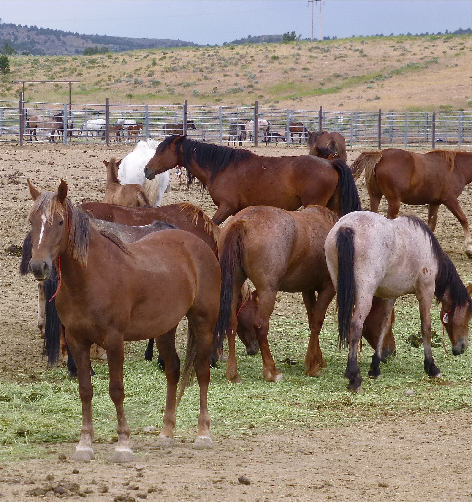
On a recent run through Oregon, I happened to visit the Bureau of Land Management’s Wild Horse corrals, just south of Burns on US 395.  The following collection of shots, hopefully, will convey the good work these public servants are engaged in.  (Click on any photo to enlarge it, but consider expanding those photos of text in order to understand the whole story.)

Of the three-day trip from Jackson Hole to home, this day was going to be the shortest, clocking in at about 325 miles.  The variable weather created a cloudscape as dramatic as the land.

I knew I had time to visit places I might otherwise pass by, something too easily done in the high desert.  It’s one thing to fly over this country in a 737.  It’s inexcusable to do so on a motorcycle, I’m thinking.

Gingerly, I guide the big Triumph up the gravel road and into the parking area.

A well-appointed kiosk contains signs that tell the story.

Mustangs and Burros, being non-native to the area, have few natural predators.  Thus, they can breed and soon over populate the delicate dry reaches of the basin and range.  The BLM makes efforts to control the population by rounding ‘em up and making them available for adoption to highly qualified applicants.  But fewer than 25% of these animals ever find adoptive ‘parents.’

A self-guided auto tour rings the expanse of the operation.  Not being in an auto, I choose to hoof a good portion of the route.

A series of chutes and corrals allow BLM wranglers to herd and sort the mustangs retrieved from the wild.  As I fumbled for my camera, a group was coaxed through this raceway.

Beyond, a complex of fence lines cordoned off areas.  Not sure I understand the sorting process…

Back at the kiosk, we are told that the colors of the wild mustangs are as varied as the colors of the landscape from which they come. 

Not being a horse person, I was surprised at the emotions I felt observing these beautiful creatures. 

Can I take this one home?

o0o

There’s a spirit or culture that exists in our west – a relationship that cleaves humankind to the land.  Integral to that relationship, I come to believe, are the horses - wild or otherwise - of the high desert.

Perhaps this poem says it best...

And like so many other times when I stop to check something out on the open road, when I leave, a new tune is stuck in my head… https://www.youtube.com/watch?v=9iteRKvRKFA

o0o

More about the BLM’s efforts in this regard: http://momentsoftruthproject.com/oregonblm

A little on-line research shows that there is some controversy surrounding this program related both to the herding practices (the use of helicopters) and some of the sterilization efforts.  I, myself, had harbored some concerns about restricting the freedom of these wild beauties, but, with consideration to their non-native status, I begin to understand the rationale for the program.  All that said, a visit to this BLM facility is engaging and informative and worth an hour’s respite from the road, offering a fine opportunity for one to form his or her own opinion on the matter.

© 2017
Church of the Open Road Press

Monday, July 3, 2017

GEM: LET’S VISIT WAGONTIRE, OREGON!


On the road from the Jackson Hole Writers Conference

Early in my college career, I enrolled in “California Geography,” a class taught by Dr. David Lantis.  In speaking of highway corridors, he referred to some bergs at GEMs, his acronym of “Gas, Eats, and Motel.”  We’ve all seen ‘em.

We’ve also seen ghost towns.

Thirty-five years ago, I was traveling north toward Spokane, Washington on US 395 on a 1981 BMW R-65 motorcycle.  The 650cc Beemer was my first foray straddling anything that could do distance in relative comfort.  The rub, I soon found out, related to fuel capacity.  Although the little machine returned good economy, when crossing the high sage desert, one didn’t want to pass a gas station.  Fortunately, just after the amber idiot light illuminated indicating low fuel, I rolled into Wagontire, Oregon.  Leaving a ten on the counter of the cafĂ©/store, I pumped about four gallons of regular (all they offered there) and went in to retrieve my change.

Last week, I rolled through Wagontire again.  Good thing I wasn’t running short of fuel on the big T-Bird.


Ghost towns like Calico, Bodie, Paxton or Twain CA, I usually associate with the bust that follows some sort of a boom – the decline after the gold or silver plays out, the movement of railroad construction further down the line, or a slump in the timber industry.  Maybe prolonged drought.  I also figure that ghost towns haven’t been real towns with bars, schools, churches and residents for well over a hundred years.

But what about Wagontire?  I clearly remember when I could get fuel, get fed and get a night’s rest in this used-to-be GEM. On this day, however, after I pulled off to stretch my legs and rest my bum, the highlighted activity of the moment was a ball of sage slowly rolling across the highway pushed by a light southwesterly breeze.

It had been 28 miles since I’d turned south on 395 at Riley and it would be another 84 until I got to Lakeview.  The first half of that 112-mile run would be through high sage desert rolling over slight undulations and across ancient playas.  The latter half, along the Albert Rim would be more scenic, but there wasn’t going to be any gas.


I’m not sure what might have kept Wagontire afloat during its halcyon years.  Given that a wagon tire is that steel rim placed on a spoked wooden wheel attached to a buckboard’s axle, I suspect the site dates back to the days of horses and buggy whips. 

Perhaps they ran cattle in these parts. 

Maybe it was a jumping off point for some high desert hunting.  There is evidence, after all of a one-time landing strip. 

Maybe it simply served as a little resort for those seeking solitude in the middle of nowhere.  A strong argument could be made that Wagontire is the middle of nowhere.

I figure that since modern transportation allows that a hundred-plus-mile gap between filling stations is nothing of concern, Wagontire now crumbles and dissolves into the desert floor.


Among the mental games I play when riding through an at-one-time-somewhere is imagining what life was like in the day.  Heading south on 395, the Wagontire words that came to mind were open space, fresh air, sage (of course), peace, solitude and starry nights.

Ashes to ashes, dust to dust. 

But as I ride south toward home, the sage, solitude and presumed starry nights of this once-necessary GEM continue to intrigue me.

© 2017
Church of the Open Road Press

Friday, April 17, 2015

LESSONS FROM THE SIDE OF THE ROAD


 Tonopah, Death Valley, Bridgeport Loop Tour
An epilogue

Two great pleasures of taking to the open road are the things you are bound to see and the lessons you might draw from seeing ‘em.  The recent trip to the west’s vast Basin and Ranges through Tonopah, Death Valley and Bridgeport provided much to see and much to think about.

At random, here are some photos that didn’t fit any of the trip’s narratives and some possibly unrelated thoughts that occurred while in the saddle.

If old trucks could talk, they’d have interesting stories to tell.

50s era Tonopah Commute Vehicle
Wonder how much he'd take for that '64 Bronco?
Gold, silver, talc and borax: it’s easy to think that mineral wealth is endless.

Playa - just dig here...
At Badwater

A town of 1,100 inhabitants is considered large, but a town of about 200 may support a radio station.

Back streets of Goldfield, NV
Every pair of ruts that leaves the highway and heads over a distant hill goes to someplace where something happened.

Whether in the Mojave...

...or on the Modoc Plateau

When personal transportation consisted of a burro carrying one’s grubstake, people still got around.

Keep stuffing what?
In the sparsely populated region east of the Sierra and west of the Rockies, if someone to whom you were related lived in town for a spell, someone in that town still remembers ‘em.

Nearest neighbors
It takes longer for scars to heal in the Basin and Range, but the scars tell us interesting things about the grit of those who settled the region.

People out this way seem not to simply get tired of something and toss it out; rather, they wear stuff out, sometimes leaving it where it dies.

Graveyard
The power of sunrise is incredible as is the voice of the hills in the sunset and the depth of the starry night sky.

Sunrise over the Mojave
A small town museum is not a place to pass by.

When the environment doesn’t provide enough moisture to support thick, green and beautiful forests and meadows, one becomes aware of how subtly beautiful the bedrock of our plant can be: colorful, spacious, clear, yet forever in constant, sublime change.
In bloom

Panamint Valley

History fades, but not quickly.

Detritus along the T and T

The first dozen and a half years of my father’s time were spent growing up and roaming the gritty extents of Utah, Nevada, Arizona and the Mojave – our continent’s great Basin and Range.  After his stint in the Army during World War II, he found himself Californi-ized: landing first in the LA Basin and later relocating to the northern Sacramento Valley where he and Mom raised two boys.

The Old Timer
Dad always seemed to itch for something.  I couldn’t understand what.  We had lakes and trails and meadows and forests; blossoming orchards in the spring, cool mountains to retreat to in the summer, ripened fruit during harvest and warm, wood-fueled heat during our dank, foggy winters.  What more could you wish for? I wondered.

One of the missions of this tour was to walk in ‘the Old Timers’ footsteps from seventy years ago.  In that effort I was totally unsuccessful, except that now, I think I know what that itch was all about: the recurring, seductive call of the desert.  That wistful call will serve as this trip’s principal lesson.

© 2015
Church of the Open Road Press