high point of my day

Seventy-five miles to the east,
Mount Lassen rose in tiny blue splendor over the gray, smoggy haze of the North
Valley. By pivoting 180 degrees, I
could make out a thin fogbank just off the California coast. Lassen and the coast: two of my
favorite and most inspirational places.
Standing atop Hull Mountain was sure to be the high point of my day.
Chatting with Jim, my new-to-me barber – I’m a relatively new
resident of this town – he shared that growing up in Potter Valley, on hunting
trips, a hike to the top of Hull Mountain made up for the fact that he rarely
shot a buck. “The view is 360
degrees of marvelous.” He’d
mentioned Lassen and the coast, but also talked about nearby Snow Mountain,
highest point in the Coast Range and one of my dad’s favorite hikes; the
Trinity Alps, due north; North and South Yolla Bolly Peaks, short of the
Trinities and the place where, I imagine, Dad hikes toward eternity; and a
number of other sites and promontories more or less meaningful to a kid who
grew up in Chico.
My bucket list had received yet another an addition.

Hull Mountain (6837’) is located
near the Lake and Mendocino County line, twelve rocky miles north of the Lake
Pillsbury airstrip at Gravelly Valley. The closest
pavement is at Lake Pillsbury, but getting to that tarmac involves twenty or so
miles of graded gravel. Don’t
bring the Lexus. No longer owning
a dual-sport, and never quite competent enough on the one for my own comfort,
Edward and I embarked on this journey in the trusty Nissan Frontier, although
I’m sure this would be an adventuresome blast on a KLR or like motorbike.

As Mendocino Forest Road 1 ascends from the Pillsbury basin,
we wind from oak woodlands trough a pine and fir belt. Along the way, views unfold as the road
zigzags in and out of creek drainages and across the spine of Coast Range.

Various campsites – I assume frequented by hunters – offer
places to pause and take in the view.
As Pillsbury shrinks in the distance, the far rim of Clear Lake becomes
visible on the horizon.

The canyons are deep and the ridges to the west seem
infinite. Distant trails and
tracks make me wonder how you get to them and what you’d find if you took
‘em. There is a nicely maintained,
but strenuous trail from near the lake to the summit of Hull Mountain. I used a knee-in-line-for-replacement excuse not to hike, thus I drove.

At one sweeping turn, a view to the immediate east-southeast
affords a look at Snow Mountain.
Dad was about my age – maybe a little younger – when he and his hiking
buddy first climbed it. It became
an annual trip for them and his knees were in far worse shape than mine.
Almost twelve miles to the tenth from the landing strip, a
far more challenging road hangs a tight right and bumps, jostles and snakes to
Hull’s summit. The main road, M-1,
would carry us to Windy Gap and the trailhead to the Yuki Wilderness and then,
twenty miles on, to Mendocino Pass.

I parked at the base of the Jeep road and pretended I was
Dad, even if it was only a few hundred yards to the top.

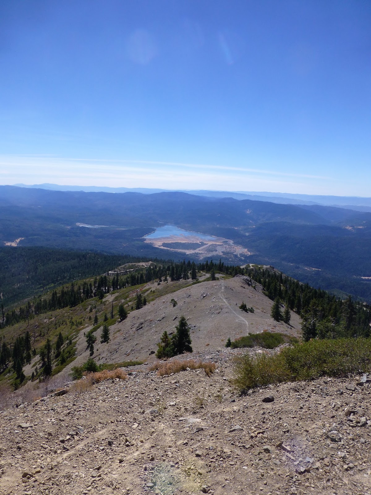
Several routes wind toward the summit. Switch-backing from where I’d parked, I
chose the most moderate route, one which circled around the east face of the
mountain. Those infinite canyons
and ridges to the west? They’re on
the east side too. Were one to
draw a straight line across the Coast Range from the Sacramento Valley to the
Pacific, this mountain would be almost mid way.

Near the top, the tangle of roads end. A beaten and derelict steel stairway
leads to foundational remains of what once was a fire lookout tower. At the top of those stairs I am
reminded that fire lookouts always have fabulous views.

Barber Jim was right.
There was Lassen. Opposite,
the coast with a rim of melting fog off shore.
To the south: Lake Pillsbury and a bit more of Clear Lake –
and Mount Konocti, sacred for centuries to the local Xa-Ben-Na-Po Band of Pomo
Indians and one of the more impressive landmarks in Lake County. North, indeed were the Yolla Bollys,
but it was too hazy this day to make out the Trinities.

Stumbling around up there, Edward and I found remnants of
that old fire tower as well as myriad shell casings from those who likely
collectively bagged more than a few nice sized bucks. Unfortunately, the USGS benchmark for Hull Mountain had been
purloined as a souvenir for somebody’s bookshelf. Damn them.

Enjoying the clear freshness of the late September alpine
air, we came across an area denizen sunning peacefully in a crevasse.

I reined Edward close knowing that the
nearest veterinarian would be three-and-a-half torturous hours away. We hiked back down to the truck extra
alert for any of this critter’s cousins.
o0o
Notes: Here’s a link to an interesting blog highlighting special
places in Northern California. In
this post, the author has taken that trail from down below to the summit of
Hull Mountain, encountering some snow along the way. Great commentary and a cool narrative video which proves to be much better than the photos I was able to grab. http://www.exploringnorcal.com/2011/02/hull-mountain-mendocino-national-forest.html
“Arturo’s been bad.” There is limited (read: no) cell phone
coverage in many reaches of the Coast Range. Back down the road toward Potter Valley, I checked my messages,
finding one. A frustrated young
voice reported: “Hello Mr. (garbled). I will be calling
you on your other line to discuss with you Arturo’s bad behavior today in
school. (click)” I don’t
have an Arturo, but as a former school principal I’ve known several “Arturos.” I thought about returning the young vice
principal’s call to say, “Before you lower the boom on his dad, think of
something positive about Arturo that you can share. It’ll make things go easier for you.” But I didn’t.
o0o

Today’s Route: Lake Pillsbury may be accessed by
following the signs from Upper Lake on CA 20 or through Potter Valley turning
right at the store. From Lake
Pillsbury, travel north and then west through Gravelly Valley and the airstrip
on forest road M-6. About four
miles east, turn left at the junction of M-1 continuing for about eight
miles. Return: Retrace, or continue north on M-1 past
the Yuki Wilderness Area Trailhead, Monkey Rock and Bald Mountain to the
junction of FR 7 at Mendocino Pass.
From there, east will take you to Elk Creek and Willows (allow three
hours); or west to Covelo, then south on CA 162 to US 101 north of Willits.
© 2106
Church of the Open Road
Press
Traveled trough this whole area as a kid in the 60’s and 70’s. It was heavily forested back then. The red and white fir trees at altitude were spectacular. So much has changed.
ReplyDeleteHello, I came upon this as I am preparing to ride a bicycle over Hull next week. I'd love to connect with you, looking to the future. I am also a retired educator...great blog. I enjoyed it and am looking to tour the Bell Springs Rd area in 2026. kestrelcraft@gmail.com
ReplyDelete