Showing posts with label Sutter Buttes. Show all posts

Saturday, March 2, 2013

EAST SIDE OF THE RIVER


Not on California State Route 45

The Sacramento River is a silent, strong workhorse.  The river sources itself off the flanks of Mount Shasta, way up north in Siskiyou County.  It collects minerals and vegetable matter and, not withstanding the recent appearance of Shasta Dam, transports its load south to deposit throughout the broad Sacramento Valley.  The rich loam on the valley floor provides the best growing anywhere in the world.

Roads in the valley are generally straight, providing no real challenge for the motorcycle rider.  The exceptions are those routes that trace the river’s banks or levees.  State Route 45’s seventy miles between Knight’s Landing and Hamilton City (and some neighboring secondary roads) offer a pleasing respite from I-5 or SR 99 with sweeping turns and nice views of the workhorse.           

Such then, was my plan.  Except that I started on those secondary roads and never actually got to 45.


The Knight’s Landing Bridge is a rather unadorned crossing of the Sacramento River.  The bridge’s spray painted label looks as if it were an afterthought.  Walking across the span, one is afforded a nice view up the river.  Just below, a resident lives in a houseboat that rises and falls with the rhythms of the river.  Not bad. 

Immediately across the bridge, Cranmore Road heads west and follows the river’s winding levee.   

A once-near-classic Cris-Craft, having seen far better days, serves as the landmark for the turn.

Cranmore Road is not well maintained.  The pavement is rough enough to not invite spirited use of the throttle.  But that’s okay.  Views along the languid river are beautiful.

It is said that in Africa, toward the end of their lives, elephants find special places to greet eternity.  Elephant graveyards, they’re known as.  

In America, the same might be said for Studebakers.  This is the second of such hollowed places I’ve run across in my travels.

Much has been done to contain and control the Sacramento River.  No longer does it flood the valley in winter spreading new nutrients to the deep fertile loam.  Levees can only contain so much, so at various places, weirs are constructed allowing water to flow into by-passes, thus relieving pressure down stream.

At Tisdale, excess water flows into the Sutter by-pass.  When not in use, the facility serves as a launching point for folks who’d rather not work today.


State Route 20 crosses the river at Meridian – a town located where the Mount Diablo Meridian bisects the Sacramento.  The bridge is an elegant little suspension span that pivots to allow channel traffic to pass.

Throughout the journey, if the paved road isn’t riding atop the levee, little gravel access roads tempt the passer-by. 


 In the shadows of the Sutter Buttes…

…one finds many implement graveyards scattered here and there…

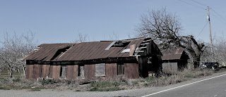
…and barns of many different construction materials like this corrugated metal building just waiting for the next big wind to blow it into the river.
But, with all that old stuff, it is interesting to find modern big-scale farming deploying some land for solar power collection.  I passed three of these solar farms this day.

Llano Seco is one of the few remaining properties secured during the days of the Mexican Land Grants.  170 years ago, these grants were enticements for folks to settle the California interior – perhaps to prevent an influx of Americans that might ultimately overthrow the Mexican powers-that-be.  (Apparently nobody told Capt. John C. Fremont or James Marshall over in Coloma.)

Once rich wheat, then rice acreage, much of it serves as a haven along the Pacific Coast flyway.


I spent twenty-eight years growing up in Chico living along Chico Creek, but I’d never made it out to its confluence with the river.  Until today. 

Looking east, the creek is the placid little stream I remember wading in and building dams across. 

Where it joins the river it is a mud flat thick with cattails.  Once known as the “Wash Out,” it was a great place for high schoolers to enjoy some clandestine beer on a Saturday night.

Up stream of this confluence, the river appears wide and lazy, but tossing an errant stick into it, one soon becomes aware of its swift and unrelenting flow.


Crossing the river wasn't always so easy or convenient.  As recently as the 1960s, cable ferries at Ord Bend and Princeton shuttled farm vehicles and residents from one side to the other.  Dad used to drive us out to the river in the old '54 Ford wagon just to ride ‘em.  

I stumbled across the remains of the Princeton Ferry rusting and rotting just above stream level.  And atop the levee just behind the hulk?  That's State Route 45: the road not taken this day.

Between Chico and Hamilton City, the narrow, steel trussed Gianella Bridge carried traffic for decades.  While working for a local route delivery company in the 70s, a colleague named Mark Stoy (for the purposes of this story) had the Westside route.  Daily he’d steer a big old Ford bobtail across the bridge and about twice a month, he’d return to the warehouse missing a mirror having clipped it on the side of the bridge, or worse, on some unsuspecting on-coming vehicle.  All of which prompted the boss to say: “If you’re on the Gianella Bridge and you see Stoy coming from the other direction, the safest thing to do is jump off.”

The old bridge is now gone and here is the replacement:

Next trip:  Looks as if I’ll need to rocket up to Hamilton City planning to take a day exploring the west side of the river on and off SR 45.


Today’s Route:  Carry a good local map – don’t rely on GPS!  I-5 to Woodland; north on SR 113 to Knight’s Landing; cross river: left on Cranmore Road (landmark: busted up Cris-Craft).  Follow Cranmore Road through Kirkville, and Cranmore (see if you can find either of these places) always bearing west toward river.  Short of Grimes, right on S Meridian Rd; cross under bridge at Meridian, continue north on N Meridian, becoming Butte Slough Road and leading to Colusa.  North on River Road to Princeton area.  Left on Rd XX – crummy pavement, broken glass, loop west, north and then east on Rd 69 to Afton Rd.  North on Afton Rd; Cross SR 162; north, then east to Seven Mile Lane; north (left) on Seven Mile; west on Ord Ferry; North on River Road; left to continue on River Road at Chico River Road (don’t be confused); North to SR 32; cross River at Gianella. 
            Return:  West on 32 to Hamilton City; south on 45 to Knight’s Landing; OR east on 32 to Chico; south on SR 99.

© 2013
Church of the Open Road Press

Saturday, January 19, 2013

CIRCUMNAVIGATING CALIFORNIA’S SUTTER BUTTES


It was my night to cook.  But it had been two-and-a-half years since my last “annual winter” motorcycle sojourn around the scenic and mystical Sutter Buttes and today’s weather was better than fair.

The route around the this eons-old formation is a combination of flat, straight nicely surfaced roadways punctuated with a few sweeping curves.  The life-blood of the Sacramento Valley is farming.  This little tour offers great glimpses into that agrarian roots.  At points along the loop, gentle rises offer views of either the Coast Range to the west or the Sierra to the east.  This day I would clearly see Mount Lassen, the next volcano in the string, as well as the snow glazed Trinity Alps peeking over the northern horizon.

The Sutter Buttes provide a touchstone viewable from almost anywhere in the Sacramento Valley.  As one travels from Red Bluff to Sacramento or Stockton, the position of the Buttes tells you how close (or far) you are from your destination.  Back when California was being wrested from the Mexican government, prior to the Gold Rush, John C. Fremont and his band used these highlands as a wintering spot during a wet and boggy trip down the valley. 

To the west and south, rice is king.  Known as the Butte Sink, the basin here holds water that is leveed into curvaceous tracts. 

Not sure if the paddies have yet been seeded, but all manner of waterfowl have chosen these stretches to gambol or float or dive for bugs or aquatic food.

To the north and east, almond orchards lay in wait of the spring warmth that will festoon branches with fragrant white blossoms. 

The mantles of the mountain are greening.  On the formation’s flanks, sheep graze, some climbing into and out of tiny ravines flush with runoff.  They eye me as I ride by and some bolt away.  Cattle reside in the area but they simply stand there, more or less aloof on the hoof, knowing I’m not going to hop the fence and take out a weak one. 

Here and there, Pacific Gas and Electric has sunk wells to suck natural gas from beneath the surface.  Yet again, I don’t stop for enough pictures.


The town of Sutter sits in the foreground of the Buttes.  It isn’t particularly picturesque, but it lives an honest existence where residents tend the pasturelands, grow almonds, fruit or rice, provide wintering habitat for migrating birds and care for the ancient and reverence-provoking “Middle Mountain.”  The Buttes Grocery and Meats is on a thoroughfare that beelines over to State Route 20.  Inside I approach the meat counter and request a whole chicken.  The butcher comes out with one that weighs in at well under three pounds.

“You got another just like that?”

“Yep.”

Skinny bird two looks as if it came from the same brood.  He packages both and after waiting while the young clerk toys with a neighbor gent’s change, I make my purchase, saddle up and head the 45 miles home.  Along the way, I contemplate the joys of small-town banter and rural living and my personal need to return to such areas now and then for some grounding in a different reality.


Five o’clock comes early this day.  I am watching the sun set over ridge upon ridge of concrete tile roofs contrasting that with what sunset must look like from a farmhouse on the edge of the Butte Sink.  I monitor the progress on the two skinny chickens in the smoker, enjoying a Romeo y Julieta Reserva Real with a dram of Knob Creek over ice.  Ahhhh.

I decide that there are at least three elements to a really good day.  They include:  Great weather, a pleasant motorcycle ride, and a little time next to the barbecue with, perhaps, a dram of hooch and a nice cigar reflecting on the how lucky one can be.


Today’s Route:
SR 20 west from Yuba City; north on Township; east on Pennington which becomes North Butte Road; south on West Butte Road (the verdant Butte Sink will be on our right, the mountain on your left); east on Pass Road to Sutter – stopping by the Thompson Seedless Grape marker before arriving in town; follow your nose east on Butte House Road or south back to SR 20.

Notes:

The Middle Mountain Foundation protects the delicate Buttes and offers guided adventures into the heart of this little-known area.  Their website invites us to visit http://www.middlemountain.org/index.html and is worth a look.


© 2013
Church of the Open Road Press

Thursday, December 24, 2009

Western Waterfowl Conference - Sutter Buttes Loop

DATELINE: SUTTER, CALIFORNIA. The 18,134th annual western hemisphere waterfowl meetings continue this winter in Sutter County. Tens of thousands of convention attendees from as far away as Canada, Alaska, and even the Arctic Circle gathered for this annual confab. Local residents had prepared for the event by flooding area resources providing food, shelter and recreation for weary and distant travelers. “Even though times are tough,” stated one organizer, “we were able to put this together without negatively impacting our resource reserves. We really wanted to protect our nest eggs.”

In the convention area just south of the Sutter Buttes, the mood was festive and congenial with flocks of visitors milling throughout the area and winging from one session to the next. The chatter among those present seemed cordial for the most part and any language barrier that may have existed separating those from Siberia or Chile with their North American counter-parts seemed insignificant.

While a conference program was not made available to the press, sessions on climate change and its impact on habitat may have been high on the list of topics.

Scenic flights were available throughout the day on no particular schedule. Following a recent early-winter rainstorm, the air was spectacularly clear given the normal propensity for Tule fog this time of year. Once airborne, conventioneers could easily enjoy views as far north as Mount Shasta and Lassen Peak, east to the Sierra Buttes and the Crystal Range, and west and southwest to the Coast Ranges and Mounts Tamalpais and Diablo.

At one point, at least a section of the assembled appeared to be startled by what may have been a gatecrasher. A large number of participants seemed to rise as one frustrating the individual who reportedly sought only to be pictured with members of this gathering. It was thought the intruder may have been shooting pilot footage for a reality program planned for the Animal Planet cable channel. Identified as a Mr. Fox, it is unclear whether he had other designs as well. Security suggested that, “this happens all the time,” but was confident that no harm had come to any of the registered guests. No investigation is planned.

The gathering is scheduled to continue through mid-February with visitors coming and going throughout the upcoming eight-week period.

© 2009
Church of the Open Road Press