Saturday, December 26, 2020

2020: THE CHURCH OF THE OPEN ROAD’S YEAR IN REVIEW


…as random and crazy as the year departing was, 

expect little or no order herewith…


We’ll start with Edward’s annual first-week-in-January “Polar Bear” swim in Lake Sonoma (with the best stick ever)…


Our area would again be visited by fire this year…


…and circumstances curtailed a bit of travel, but I did revisit some favored roads.


The coast has replaced the Sierra as our go-to place for beauty and reflection…


…any time of the year…


…with all manner of creatures…


…and hidden little Edens.


We bid farewell to Romeo…


…a classic BMW that deserved better than to be gathering dust in the garage… 


…and Mom found permanent rest in this favored place.  (Photo circa 1967)


A ‘chase car’ trip to Central Oregon afforded us this view of Shasta…


…a week on the Metolius River…


…a visit to McKenzie Pass…


…and a loop down the Oregon Coast.


Random additional images include:  Sunset at Bandon, Oregon…


…a perfunctory derelict truck…


…a nice new-to-me section of pavement…


…and “OH! NO!”


Best book among the many read this year?  Dr. Lepore (Closed circuit to folks at the WSJ: A woman with a PhD is a doctor) offers a readable 400-plus year history of the United States reminding us that we do have ideals, but we don’t always stand up for ‘em the way we say we do. Witness the past few years.  (Allow about a month to finish it, but well worth the effort).


Shots of the year as judged by our panel of expert (yes: ‘expert’ is singular.)


5th Runner Up: representing too little time with Grandkids in the real world this year:


4th Runner Up: because we want them grandkids never to miss critters like this:


3rd Runner Up: Coastal School (or fire?) Bell.


2nd Runner Up: Dusk in Upper Lake, California.


Shot of the Year: Thomas Kincade-esque Cabin across the Metolius.


Here’s hoping for a more conducive 2021 – (more conducive for damned-near everything.)


© 2020

Church of the Open Road Press


Wednesday, December 23, 2020

FOREST ROADS AND FIRE TRAILS

 …the urge to explore continues…


After calisthenics we were told to jog from the old gym out to Warner Street, tag the fence and run back.  “That’d be about a half a mile,” Coach McDonald said.  I didn’t much care for jogging – still don’t – but did enjoy the run back.  Over the roof line of


Chico High’s gymnasium I could see the foothills and the mountains where the Sierra and the Cascade met.  Feather River country.  In the fall, those far away hills were streaked with the color of changing leaves.  In the winter, cloaked with snow.  Spring would bring a greenness that highlighted the roads scratched through the forests and meadows and into the high country.  Roads I so wanted to explore.


A seven horsepower Honda Trail 90 served as the Golden Hind I’d use to discover the world in my geographical back yard.  Endless summer days were spent putt-putting along forest highways and fire roads in the Plumas and Lassen National forests.  Each day I’d turn at a junction just to see where the dirt track led, and when darkness gathered, I’d make note of the routes I hadn’t opted for and promised to do them next time, perhaps as soon as tomorrow.


Fifty years have passed since those days jogging back to the old gym and mind-wandering about the adventure of an unexplored forest road.  But the fantasy still exists.  


No longer living in Chico – we’ve enjoyed several interim addresses – now I find myself in a small berg in California’s Alexander Valley toward the northern reach of the Russian River.  Looking across to the hills, I can easily see routes and trails carved into the chemise and woodlands of the Mayacamas east of town.  Standing in the driveway after having picked up the morning paper, my gaze toward the rising sun transports me back to those high school days when I wondered, “Where does that one go?”


A paved route called the Hopland Grade traverses the Mayacamas north of us.  We’ve driven it several times.  Like a carnival ride at Disneyland, several signs warn that

if your vehicle is longer than this length, you are prohibited from the route.  Hopland Grade is windy, steep and not quick.  Great fun on a Ducati Monster, not so much on or in anything else.  Near the base of the mountains we choose an intersection with the primitive The Old Toll Road.  Winding along the east side of the Sanal Valley, past industrial strength wine vineyards, the crumbly asphalt soon snakes into the hills, over and back over a seasonal creek, and through stands of black and live oak and madrone. 


Hog wire and rotted-post fences trace the road’s edge. There’s even a point where a metal gate appears – one that if one passed through it, one would soon be hurtling over a cliff.  Pavement gone, the surface is graded to a certain extent, washboarded some and dotted with puddles from a two-nights ago late-autumn storm.  The Subaru takes this road is stride.  As did the Yamaha Super Tenere the other time I was up here.  But something makes me long for my old Trail 90.


The map tells us that atop the spine of the Mayacamas we’ll find Adobe Creek Road, and we do.  The trouble is that at the intersection with Old Toll, Adobe Creek is gated allowing access only to the rancher with the appropriate key – and Cal Fire folks, too, I assume these days.  I suspect the secured road is one I might see from my driveway, several crow-fly miles to the southwest.  We had hoped to head south and join up with Pine Mountain Road which loops back to the Alexander Valley, but that won’t be the case today – if ever.  Ahead a bit, Adobe Creek Road will take us north affording a view of Clear Lake to the east.  At several minor junctions, each fire road is gated and locked. I’m beginning to get the picture that, unlike in our national forests, a lot of these roads-begging-for-exploration are closed to lookie-loos like me.  In these lands of steep hills and dry brush, I can’t fathom what a landowner might be securing behind these barriers – cattle surely wouldn’t do well amongst these thickets and I’m sure there are easier places to grow pot now that it’s legal. 


 The map tells us that Adobe Creek Road traces the line between Mendocino and Lake counties, and that six or seven miles north, we’ll intersect with the Hopland Grade – which we would have had not another damned gate barred our way about three-quarters of a mile on.  Here, we course east on Highland Springs Road, a Lake County thoroughfare that winds down the lee side of the Mayacamas.  The trees are more sparse on this side of the summit and those that dot the hillsides are primarily blue or valley oak.   The road is wider and far less steep owing to the fact that the rains that tear away at these mountains are more prevalent on the other side.  


Twenty minutes further we arrive at a lovely – but rather primitive Lake County public park.  Centered on Highland Springs Reservoir is a rod and gun club, an extensive Frisbee golf set up, tons of picnic spots and a four-mile trail that winds up the canyon then circles around the lake.  Edward the lab-mix was ready for a walk and so were we.  Up the draw, the woods are silent, dark and deep and frost (though not Robert Frost) still glazes the mid-day ground in the shaded areas.  


Gray squirrels leap from branch to branch, taunting the dog, and a lovely pink and brown salamander wriggles across the trail barely escaping my footfall.  Tracking back to the lake, great egrets wade the shore waters, redwing blackbirds flitter amongst the rushes and osprey and red tails circle overhead.  Mallards and coots discuss the problems of their world as they paddle across the surface.  We wish we’d packed a lunch. Edward wishes we’d packed a Frisbee.


Our exploration of the enchanting back roads and dirt tracks seen from the house wasn’t exactly a bust as we learned a lot about the lay of the land.  Clement Salvatore, until recently an entertaining and insightful staple at Rider Magazine, shares that there are at least ten times as many miles of dirt road as there are paved this side of the hundredth meridian.  I wouldn’t disagree.  But many of those miles of roads are unobtainable because they cross privately held stretches of heaven.


Still, there is much to explore.  Perhaps again tomorrow?


There are times when I haven’t been out much on the big Yamaha that I think about a different – smaller, lighter two-wheeler.  My range of interest goes frothe adorable Vespa 300 HPE to the spartan Royal Enfield Himalayan to the newly re-issued Honda CT 125, a descendent of my old Trail 90.  Likewise, I sometimes think the Subaru Forester is a bit stodgy and wouldn’t I prefer a Mini Cooper Convertible or maybe a rugged Jeep Wrangler forgetting what a nightmare my 1990 Wrangler turned out to be.


But, for exploring the high and lost fire roads of Sonoma, Mendocino, and Lake Counties, and for getting me safely (read: “at highway speed”) to and from those dirt roads, it’s tough to beat the two vehicles I have.  Dependable, economical, rugged and fairly comfortable, I recall that many times when I’ve answered the siren song of something more stylish, I’ve been disappointed with the result.  Reference here – along with that Jeep – my short-lived but gorgeous Triumph Thunderbird.


Then there’s this unavoidable positive: Both the Yamaha and the Subaru are paid for. 


© 2020

Church of the Open Road Press

Saturday, October 3, 2020

RETURN TO MENDOCINO AND A VISIT TO FERN CANYON

 ...seeking respite from, well, everything...


In an effort to escape the end-of-the-world smoke of our inland valley berg, we loaded up the all-electric Chevy Bolt with two night’s worth of duds and headed over to Mendocino.


The quaint New England-esque village is day-trip-able, but by staying a couple of nights, more could be explored and more in depth.


Speaking of depths, long on the bucket list was a hike into the depths of Van Damme State Park’s Fern Canyon.


A lovely trail traces the Little River (we never ran across the Little River Band, however) through a verdant, lush understory of ferns and fall color...


...ducking under fallen redwoods and firs, cleared in some places to maintain the trail, but left to decay and return nature to nature.


Oddities appear throughout these sheltered environs.  Here, an alien spaceship appears to have collided with a Douglas fir.


 Two-and-a-half miles in, the trail forks...


...offering a loop (with quite an elevation gain) into the Pygmy Forest...


...a region where a fifty-year-old tree might rise to five or six feet on a three-quarter inch trunk.  Something about the particulars of this biome.  The air up here is much warmer (and much smokier) than down in Fern Canyon.


Completing the loop, our trail passes through a century-old burn zone that displays the resiliency of the area sequoia.


Along the way, it looks as if we may have discovered the source of a particularly nasty signature circumstance of the year 2020.  Who knew it might be plant based?


Details delight as we complete the 8 ½ mile sojourn along the Little River through this lush and often over-looked Eden.


Upon the recommendation of friends, we holed-up at the lovely Headlands Inn... 


...walking distance from Mendocino’s Main Street and the glorious bluffs beyond.


A sea stack offers refuge for pelicans, cormorants and gulls.


Evening finds us enjoying fine northern Italian fare in the garden at Luna Trattoria – great wine list, thoughtful, efficient service, and a delightful Italian owner with a deep baritone voice – where I snap a picture of their rustic shed (because I like rustic sheds).


We followed that with a late stroll down Mendocino’s deserted Main Street.


COVID-19 has taken a toll on the tourist industry and, this early October evening, I’m afraid it shows even here.


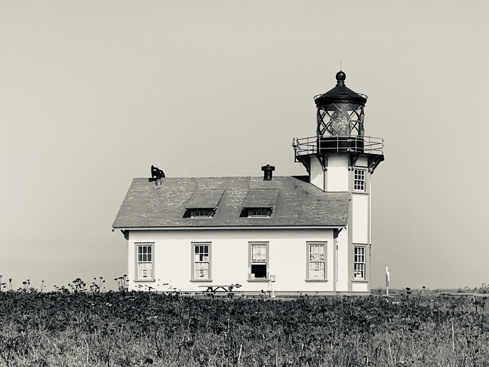
Like old sheds and old trucks, we can’t pass up an old lighthouse.  Point Cabrillo’s is only three miles up Highway 1.


It’s a half-mile walk from the parking area to the former lightkeeper’s residence.  Derelict roses edge the way...


...and a decrepit fence separates this space from that space – I suppose.


The Pacific is particularly active this morning, engaged in its eons-old quest to erode North America into the sea...


...and the Point Cabrillo Light Station has witnessed over a century of it.  (I’m reminded that I need to check my history book(s) and determine if Juan made it this far north as he explored California for Spain back in the day.)


Some hikes are a bust.  In our efforts to stave off re-entry into unhealthy air, we used a published guide to direct us to a little-used trail head just south of the Navarro River.  Once the route of the old state highway, the guide read: “Overgrown in spots...”


No kidding.  After plunging through about two hundred yards of nettles, tangled vinca, ivy, poison oak and downed power lines, we determined that discretion was the better part of valor and headed home.


o0o


Notes:


Was it mentioned earlier that I dig old trucks?  Here’s one that could stand to be dug out...


The Headlands Inn offers great views, warm ambiance and breakfasts that simply can’t be matched. We will return.  Check ‘em out:  https://www.headlandsinn.com


And check out Luna Trattoria while you’re at it:  https://www.lunatrattoria.com


(c) 2020

Church of the Open Road Press