Tuesday, October 21, 2014

IS THIS HEAVEN? NO. THIS IS CAMP SHERMAN, OREGON.


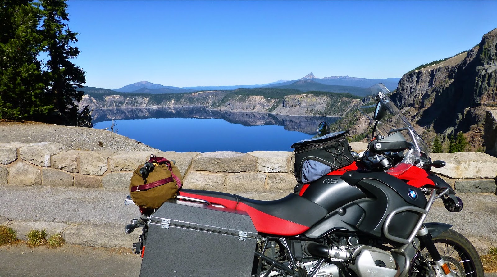
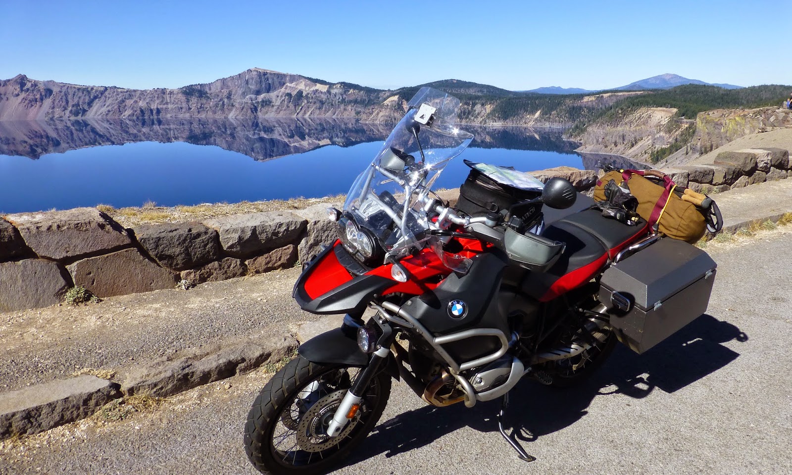
On the Volcanic Legacy Tour of California and Oregon

Dateline:  Camp Sherman, Oregon.  There is the river.  A few cabins dot the Ponderosa forest floor and a gently sloping sward of green links the forest and the stream.

And there’s the tiny but very nicely appointed general store.  Several footbridges cross the river to it.

But there is no Internet access.  Cell phone coverage is limited to a clearing called “the Crossroad” about 400 yards west.  There’s a stump you can sit on if you must make contact with the outside.

But why?  This place is perfect.


After each day’s ride, I’d grab a copy of whatever it was I was reading and head for a rustic bench positioned about seven feet back of the Metolius River.  There, with the robust flow of the spring-fed stream providing the ideal white noise for concentration, I read.  Uninterrupted for ninety minutes or more, until the sun slipped behind the stand of pines and evening’s coolness breathed in and settled across the little valley.

I said “uninterrupted,” but that was an overstatement.  Twice a pair of Mallards jetted past, their wingtips just touching the river’s surface.  Each time, they squawked as if deep in disagreement with one another or, more likely, angry with me for claiming their bench.  Then there was that hawk’s primal “good night” call just around dusk.  It still echoes.


Camp Sherman is located about twenty minutes west of Sisters, the quaint but rapidly becoming a bit too touristy home of a renowned annual quilt show.  Spanning both sides of the river, Camp Sherman is a Mecca for fisher-people and deer hunters in season. 

What do folks who do not fish or hunt do on the river?  Reading was nice.  So was a good cigar and a dram of local whiskey after a grilled steak or pit-barbecued chicken.

Upstream, it is a short walk to the source of the river: a huge and dynamic spring flowing from beneath a moss and fern covered hunk of basalt.   

Downstream, Oregon wildlife folks have established a fish hatchery in order to stock this and other area waterways.

In the vicinity are stretches of pine forest, some of which, lately, have been touched by fire. 

Further on, evidence of the area’s glacial and volcanic legacy can be found in the etched faces of the mountains, the vast acreage of impassable “aa” and the gritty, sandy, cindery ridges that, were it not for the root networks beneath the forest floor, would be eroded or simply blown away.

A good day’s drive from either Sacramento or Seattle, Camp Sherman is centrally located in Oregon and in the west.  It is a little piece of heaven that recalls rugged, yet simpler times, inviting our pulse to slow, our hearts to reflect and our spirits to be renewed. 

We’ll return.

o0o

Notes and Resources:

The Camp Sherman Store is worth the trip all by itself.  Nice collection of wines, beers and all the sundries any forgetful person might have forgotten.  I’d forgotten butter and matches and ended up with that and a six-pack of Mirror Pond Ale, brewed locally in Bend.  Had I needed a Royal Wulff or a Gray Ghost trout fly, I'm sure they'd have accommodated. 

Here is the store’s website: http://www.campshermanstore.com/ 

On this latest visit, riding brother Randy and I stayed at the Cold Spring Resort: http://www.coldspringsresort.com/ Accommodations were clean and quaint but a little tight for a couple of big buffaloes such as ourselves.


When previously visiting the area with our wives, the Metolius River Resort’s cabins proved to be quite comfortable, spacious and well appointed: http://www.metoliusriverresort.com/index.asp

The local restaurant wasn’t open for breakfast, and we didn’t pack for that, so we started each day trip with a run into Sisters where there are several nice breakfast places.

The Sisters Oregon Guide has this to say about Camp Sherman: http://www.sistersoregonguide.com/recreation-camp-sherman.html

© 2014
Church of the Open Road Press

Sunday, October 19, 2014

THE THREE SISTERS IN OREGON’S CENTRAL CASCADES AND MCKENZIE PASS LAVA FLOE


Day 4 of the Volcanic Legacy Tour
of California and Oregon


A good plan on this tour was to home base in some lovely place engaging in day trips from that central point.  Today’s sojourn would see us again “scratching God’s belly,” this time from a rugged Cascade moonscape called McKenzie Pass.

Oregon’s highway 242 twists from Sisters, the quilting capitol, fifteen miles to the summit.  Continuing on, the route descends to the McKenzie River Highway.  The pavement provides about 40 miles of challenging ride and out-of-this-world scenery.

The eastern face of the Cascades is home to vast reaches of yellow and Ponderosa pine.  The trees are generously spaced and the forest floor nicely groomed.  Little light filters through the canopy so the sage is sparse at best.  A few miles west of Sisters, an inviting sign warns travelers that vehicles longer than 35 feet in combination are prohibited.  Yippie-ky-yo!

We corkscrew up and through the range of climatic zones moving from thick forests to an environment almost completely bare.  But not because of elevation.  The summit is well below any established timberline at this latitude.


What we come upon is what we would image the surface of the moon looks like, had we not, now, possessed second-hand knowledge of that sphere.  Rocky.  Rough.  Rugged.  Inhospitable.  Perhaps impassable?

Most certainly snow falls at this elevation but no streams course down the mountain.  Instead, the mantle of snow, sometimes twenty-feet thick, simply stays in place until the spring thaw when it melts and slips through the random chunks of basalt into pumice and grit and ancient, long-buried-by-volcanic-activity forest litter.  Trickling, drops at a time, the snowmelt descends a few thousand feet into a large underground lake.  The journey takes years.

Back down at Camp Sherman, a mile or so from our rented cabin, spillage from this lake springs from beneath a mossy rock outcrop.  It appears as the fully flowing Metoluis River.  Musically, night and day, it slips past our home base.

Over on the west side of the summit, the McKenzie River is formed the same way.

Back at the summit, the Forest Service maintains and observatory named for one of their pioneering rangers, Dee Wright.

Through its portals one views the ice carved arĂȘtes of Mounts Washington and Jefferson and the Three Sisters.   

Much of the volcanism in this area preceded the last ice age.   

But slightly off to the north-northwest rests Belknap Crater, a rounded cindery dome not yet carved.  Its ice age waits.

A paved trail leads the saddle-sore among us on a twenty-minute interpretive walk.

Well-placed signs tell a story that both amazes and sizes one with his or her place in the world.


I look over the lava jumble and am moved by the expanse of time, the dynamics of an ever-changing earth and the effort those with wagons or pushcarts expended in order to reach the Willamette Valley.  So very near by now, but, ever so far.  How many of today’s citizen would be so motivated, so driven, so tough?  Probably not me…


Shortly after leaving the summit, we find ourselves winging around sweeping bends into a thicker, more moist forestscape.  Frost had kissed some of the broadleafs already making the ride a kaleidoscope of movement and color.

At the junction with the McKenzie River Highway, we route ourselves north and east over Santiam Pass and back home to Camp Sherman.  This proved to be a most pleasant 100-mile full day.

o0o

Today’s Route:  Northwest of Bend Oregon on US 20, find Sisters and nearby Camp Sherman.  Our day started on the banks of the Metolius in Camp Sherman.  Follow Camp Sherman Road south to OR 126/US 20.  East to Sisters.  West on OR 242 over McKenzie Pass to rejoin OR 126.  North on 126 (it connects with US 20 up the road a piece), then east to Camp Sherman Road.

© 2014
Church of the Open Road Press

Friday, October 17, 2014

CRATER LAKE’S RIM ROAD IN OREGON’S SOUTHERN CASCADES


Day 2 of the Volcanic Legacy Tour
of California and Oregon

The goal would be to arrive in Camp Sherman, OR early enough in the afternoon to prepare a meal for a riding buddy who’d be joining me from the north.  The map said I’d be in for about 280 miles.  


Conflicting with that dinner bell time schedule was Crater Lake.  I did not want to repeat the mistake of yesterday, flying past something good to see and regretting it tomorrow.


Departing Mount Shasta City early, a glance over my shoulder, some twenty miles north on US 97, bore a classic view of the Queen.


Apparently, I wasn’t the first traveler to be struck by her beauty.

Racing north, I passed the marker for the Butte Valley airstrip located between McDoel and Dorris.  I noted the vintage beacon tower, still operational with the power shed and fuel supply tank visible.  

I wondered if the unit might be situated atop one of those airmail directional arrows like those found along the old route of the Central Pacific in Utah and Nevada.  The airfield is adjacent to an early route of the Southern Pacific, so it stands to reason.  Lesson not yet learned, I’m still kicking myself for not hiking the two hundred yards to the facility to find out.


North of Klamath Falls, Oregon Route 140 circles to the west side of Klamath Lake.  Toward the lake’s western-most point, a secondary road heads north and east to Fort Klamath, a historic place name I’d like to visit.  I divert, hoping for pavement.

And glorious pavement it was, skirting the lake and slicing through yellow pine forests until it angles east through luscious pastureland.  A road sign on OR 62 points me toward Crater Lake and I pass through Fort Klamath with nary a blink.


I like roads that reach skyward, dancing along ridgelines high enough to where you could reach up and scratch God’s belly.  In the Sierra or the Rockies that feeling envelopes at about 11,000 feet.  In the Cascades it can happen about a mile lower.

Traveling OR 62 the view unfolds to the south.  Klamath Lake, now miles away, rests at my feet, although the haze from some California wild fires tries to steal the view.

A few miles on, cresting a gritty ridge of ash and pumice, down onto the forested side, the lake appears.

I pull in at a wide spot.  Three quarters of the way across a cinder cone has developed inside the water-filled crater of the ancient volcano. 

Two minutes further, a viewpoint affords a view of “the Phantom Ship.”  The rock is surrounded by glass smooth reflection of the lake’s rim. 

A fellow with a real camera is sighting up to take his best shot – or a hundred of ‘em.  I click and go.

In my previous visits to Crater Lake, the East Rim Drive was always closed either due to heavy snow or rockslides.  I guess one upside of climate change is open roads due to no heavy snow.

Each turn of the route offers another reflection.

I stop for an additional portrait of the motorcycle as if anything about the bike might have changed in the six minutes since the last picture of the thing.

And then another.


After a nine-hour day of riding and dismounting, the little cabin/trailer we’d secured on the banks of the Metolius River certainly proved inviting.  My three-hour detour around Crater Lake did not make dinner any later than it was going to be anyway.  Perhaps I did learn the lesson this day.

© 2014
Church of the Open Road Press

Thursday, October 16, 2014

CALIFORNIA’S NORTHERN CASCADE: MOUNT LASSEN AND MOUNT SHASTA


Day 1 of the Volcanic Legacy Tour of California and Oregon


In about 1959, my folks prodded my seven-year-old butt up to the top of a snowy Lassen Peak.  At the time it seemed like torture.  My toes frozen inside some raggedy Keds, I don’t remember enjoying anything on the way up.  Going down, however, without an inkling of how dangerous it might be, sliding down a three hundred yard snowfield made the day quite worthwhile.  There would be no snow this day.

I try to make it back every year, but it had been a while since my previous visit.  It had also been years since I’d done a road trip with my brother: he on his classic 90s era BMW 1000 GS.

Eschewing the glorious Deer Creek Highway from Chico, we bolted up CA 99 to Red Bluff.  California’s State Route 36 east of Red Bluff tilts from the valley floor and in about 36 miles rises into the volcanic ridges and floes of the Cascades.  Passing through the climatic zones on the October ascent is exhilarating.  I can’t remember the last time I’d ridden this route from farmland to forest.

Turning north on CA 89, we enter Lassen Volcanic National Park, one of the state’s best-kept secrets.  There are plenty of hikes, plenty of smells and lots of interesting flora, fauna and geology.  One could spend weeks.


Once in the park, we paused for a bike portrait with Broke Off Mountain in the background.  Broke Off is a better hike that Lassen Peak.  Longer, but a more gradual climb.  And when you get to the summit, you have a nice view of the park’s namesake mountain.  Mom and Dad pushed my butt up that one, too.


Inside the park, CA 89 winds past fumaroles, alpine lakes and ridges made of volcanic mud and ash.  Sparse vegetation, if it gains a foothold, grows slowly in these 8,000-foot climes.  Tremendous views are offered south to Lake Almanor, west to the Sacramento Valley and always of the mountain.

We pause at the Bumpass Hell trailhead and then at Summit Lake, recalling family adventures from decades ago.

But, as on too many of my trips, our goal was further up the road therefore our pauses were too brief and our cameras used too little.


CA 89 may be one of the prettiest roads anywhere in America.  It breaks off from US 395 in Mono County, crosses the spine of the Sierra Cascade and ends up uniting with I-5 in Mount Shasta, CA.

We travel through Hat Creek Valley, past McArthur/Burney Falls State Park and stop for a roadside photo-op once the Queen frames herself at the end of a straight stretch.

McCloud, CA is a moment off the highway.  The old lumbering town still has remnants of the rail line that brought timber to the mill and products to the mainline.  Brother Bill’s wife was born at the hospital there.  We find the old building is being restored.


The McCloud Hotel is a fine place for a romantic evening, but since I’m with my brother, we choose to stay at a Best Western in Mount Shasta.  An evening walk around town affords a peek at the Queen as dusk settles.


We retire wishing we’d covered a little less ground and smelled just a few more of the roses along the way.

o0o

Note to Self:  When riding with someone else I often wish I’d stop to take a picture as I whiz past something historic or beautiful, but don’t because I don’t want to hold the other guy up.  I need to quit worrying about that.

© 2014
Church of the Open Road Press

Thursday, October 2, 2014

Guzzi Falcone 2014 Tour d’ California Video


The Church of the Open Road was pleased to be included in a portion of the planning of the recent Moto Guzzi Classic Falcone’s Tour d’ California.  The ride included folks from both the States and Italy. 

The group saw some of the greatest sights California has to offer.  The video chronicles the first three or four days of the tour.  It has some terrific in motion shots of the classic bikes as well as some very nice conversations and comments from participants on the tour.

Grab a glass of wine and settle in for the forty-five minute video:


See how many roads you have ridden and how many more there are yet to discover!