Showing posts with label Hiking. Show all posts

Friday, June 28, 2024

LASSEN PARK – BLAST FROM THE PAST II

episode 2 in a weekend with extended family


Amazing how quickly a yesterday from 60-plus years ago seems like a yesterday from well… yesterday.


Candi, Brother Tim and I were driving the Lassen Park Road – it having opened for the season only a week before – stopping for alpine views, conversations with others and looking for sites for a picnic lunch. 


A few miles up the twisting route, we paused at a point to view the ragged rim of the ancient Mount Tehama. Stunted pines, dwarfed by elevation, roots cloaked in patchy snow, clung to basalt. In the distance lay Mill Creek Meadows and, beyond that, the azure, blue pool of Lake Almanor. 


A couple drove up on a black Harley Davidson, so I had to engage. A week out from Green Bay, Wisconsin, they were.  I told ‘em I was from nearby Chico. “Chico?” the man exclaimed. “We used to have one of your Chico boys in the Pack.” “Aaron Rogers,” I confirmed, “graduate of Pleasant Valley High.” “Yeah,” the man laughed. “He moved on to the Jets so we don’t care about him anymore.” Ahhh. The people you meet on the road.


State Route 89 is the highway that serpentines its way through Lassen Volcanic National Park. My pick for the most beautiful road in California, it runs from Mount Shasta City (Siskiyou County) to Topaz (Mono County) winding through volcanic legacy, high deserts, pristine lakes, tourist meccas and granite outcrops.  Beat that anywhere, I dare ya. Annually, from after the first significant snowfall of autumn until mid-June, the road is closed through Lassen ~ the 8500 foot summit too much for plows and blowers in those reaches. 


Everything seems so fresh and new just after opening. Two alpine ponds rest just below the summit. Lake Helen and its mate were both crusted with ice, but the parking lot to the Lassen Peak Trailhead was cleared. The cars of at least two dozen intrepid souls rested while their owners braved the mostly snow covered route to the 10,400 foot top. Not today for us.


At Kings Creek meadow we found the footing a bit dicey, so on to Summit Lake where we would pause for some crackers and cheese and fresh fruit. Or would we? The steel gates to the camping area were securely locked. Picnic area unavailable. I turned the Subaru around to retrace our steps. But Candi said, essentially, Not yet. Another U-turn (looking like damned out-of-state tourists) and we pressed a mile or two further.


Beginning on page 151 of “Eden, Indeed,”* in a recollection about my delivering foodstuffs to a fire camp on the Mendocino, a brief back story is offered about a 12-year-old me, on the Twin Lakes Trail in Lassen Park, hiking with Dad. 


A ‘call of nature’ prompts me to stray off trail when I find myself peeing into really warm duff.  Something wasn’t right and at Dad’s command, I hightailed it down the trail to the ranger’s outpost near where he’d parked his Jeepster.  


Almost before I could get the words out about the hot duff, the ranger grabbed a Pulaski, told me a little something about the nature of lightning strikes and raced up the trail.  I stood in the vacant ranger station not knowing what to do or where to go until Dad clambered down the trail lugging my Kelty Pack along with his own.


That mile or two further found us at the old outpost.  I walked across the parking area to the Echo Lake Trail that now had a wooden walkway crossing the meadow.  The place names on the directional sign were all familiar.  


I’d hiked to most of them and a carousel of memories circled in my head.  The bridge was new.  The sign was, too.  But everything else was exactly the same.

Almost.  Across the meadow beyond the bridge, the pine forest was a collection of denuded stumps and spikes, victims of 2022’s Dixie Fire which started forty miles away over ridges and down canyons. 


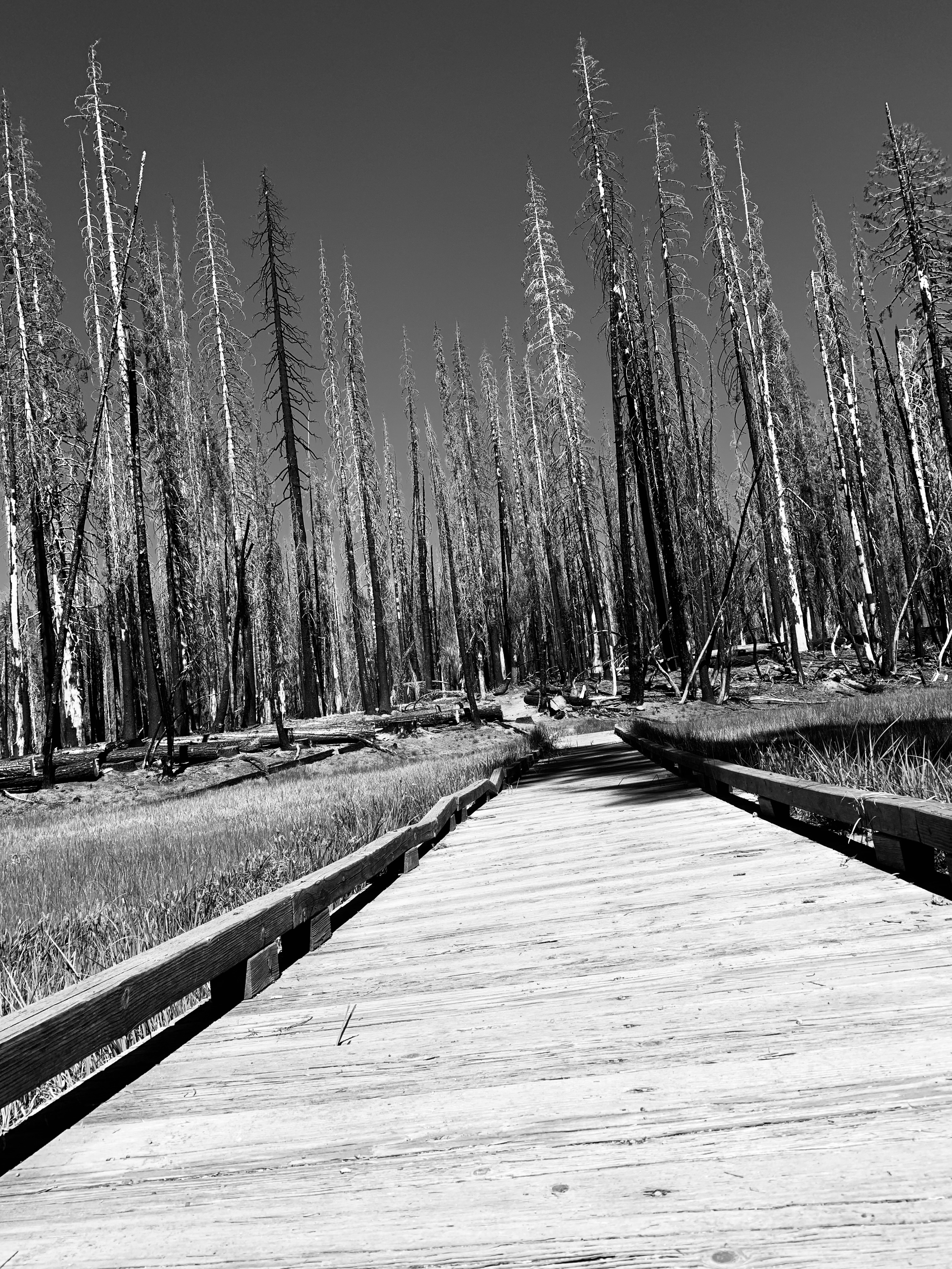
Standing next to the trail sign I recalled the ranger and his Pulaski and wondered if this might have been the result sixty years before had a young kid not ventured off the trail to pee.  Or was that just yesterday?


© 2024

Church of the Open Road Press


* Don’t yet have your copy of Eden, Indeed?  It’s still available to order from your local independent bookstore (it's in the Ingram-Spark catalog) or through your favorite online source. (The Church of the Open Road always recommends doing business with the former...)

Monday, February 14, 2022

THE GREAT REDWOOD TRAIL: DREAMS AND CHALLENGES

 Part 3 (of 3):  Rails to Trails in Our Backyard


In my garage rests a beautiful Peugeot ten-speed that I purchased new in 1972.  Back then I used it to commute to class at Chico State and later, occasionally, to my teaching assignment eight miles south in Durham on a bike path that once was the route of the Sacramento Northern Railway. 


         So, the idea of a hiking/biking path from Cloverdale to Humboldt Bay sets my mind to dreaming of hopping on the Peugeot and pedaling the entire distance.  Imagine! Following the route of the old Northwestern Pacific through vineyards and foothills to Ukiah and Willits then though the rugged and remote Eel River canyon, tunneling beneath stands of redwoods and madrone, ultimately arriving at the coast with its sea gull calls and wisps of salt air.  [Understand that I get a bit tuckered out just cycling back from the coffee joint just a few blocks downtown, but that’s beside the point.]


In the early 1900s, the NWP appeared to be a good transportation idea, one that would link the Eureka area with the outside world, sending redwood south and agricultural goods, manufactured products, and tourists north.  But geology, geomorphology, and weather ~ essentially Mother Nature, herself ~ had other ideas.  So, railbanking the route (preserving the grade but no longer enabling rail traffic) and repurposing it as a recreational trail seems a good use of her remains.  

         A roadblock may be around the bend, however.  A group interested in transporting coal from Wyoming’s Powder River Basin (Hey!  That’s Walt Longmire’s neck of the woods!) to export markets in Asia has proposed revitalizing the old NWP as a critical link from the Union Pacific right-of-way near Suisun to a yet-to-be-built transshipment facility at Humboldt Bay.  Called the North Coast Railroad Company, the group has filed formal opposition to the proposal to railbank the old NWP route and convert it to trail.  The Company intends to acquire the line “and restore it to operating condition to support future, high-volume traffic flows.” The company claims that it has $1.2 billion in their pocket(s), but those in the know suggest it would cost twice that to restore the line.  


        Political leaders ranging from local city council members to area Congress-folk are lining up against the efforts to return freight traffic for a couple of reasons.  1) Globally, the growing belief that burning fossil fuel such as coal is harmful to the planet; and 2) locally, the persnickety nature of Mother Nature and her inclination to toss a trainload of subbituminous coal into the Eel in the event of a track failure or landslide.  

         It will be interesting to see if the coal train somehow derails the Great Redwood Trail.


Absent the above, it may be ten or more years before the Great Redwood Trail comes fully to fruition.  In those years, issues like the protection of neighboring property, accommodation of overnight campers, infrastructure maintenance and trail security will be addressed and resolved.  However, given that time frame, my dream of pedaling from here to Eureka on a then-60-year-old bicycle ~ at age 80-plus myself ~ may always be just a dream.  

         But that old Peugeot is a darned good bike and I have a strapping grandkid or two who’ll be about 25 at the time. 


Hmmmm…  Guess who might be getting an antique ten speed and, along with that, a mission…


Resources:

For more information on the history of the Northwestern Pacific Railroad, check out: http://www.nwprrhs.org/history.html

For progress and details on the Great Redwood Trail, see:  http://www.thegreatredwoodtrail.org


© 2022

Church of the Open Road Press

Monday, January 31, 2022

THE GREAT REDWOOD TRAIL: CONCEPT AND PROPOSAL

 Part 2 (of 3): Rails to Trails in our Backyard


The completion of the transcontinental railroad in 1869 linking east to west ushered in the golden age of railroads in the United States. Midwestern wheat easily shipped to east coast flour mills, Kansas feedlot cattle mooooved almost effortlessly to east coast markets, and folks could cross from east coast to west in days rather than months. The magic carpet made of steel sealed the early 19th century doctrine that American expansion across the continent was inevitable.  And, until the 1950s, rail was most certainly king.


         In 1956, The Federal-Aid Highway Act authorized the construction of a 41,000-mile network of interstate highways that would span the nation, and rail transportation’s dominance began to fade.  Some opine that the last most profitable year for the freight rail industry was when trains transported the cement that was used to build the interstates.  That may or may not be true, but as trucking allowed more flexibility, rail lines became less feasible, and many were ultimately abandoned.

         The “Rails to Trails” movement sought to repurpose these rights-of-way.  Given that out of necessity, rail lines rarely exceeded a grade of 2% ~ that is two feet of rise for every 100 feet in distance ~ rail grades could and do offer easy walkin’ and ridin’ for hikers and bicyclists.  Many provide access to some of the most beautiful, rugged, and remote quarters of the west: The Bizz Johnson Trail on the old Pacific Fruit Express line skirts Fredonyer Pass in Lassen County; miles of the old Tonopah and Tidewater slip toward the edge of Death Valley at Rhyolite (my dad worked for the T&T); and the original route of the Central Pacific over Donner Pass invites hikers through tunnels chiseled and blasted back in the 1860s.  (Even today, if you listen carefully, you can still hear the echoing ping of the picks striking the granite.)


The Great Redwood Trail is envisioned as repurposing the old Northwestern Pacific line from Cloverdale, through the Eel River canyon to Rohnerville and Eureka.  The route will use existing bridges and tunnels ~ work around them where necessary ~ and split the third largest watershed in the entire state.  Travelers will hike through the ancestral homelands of the Yuki people, cross ranchlands that date back to the mid 1800s, and ultimately follow the edge of a languid Eel River as it meanders along the coastal plain en route to the sea.  Along the way, the adventuresome will observe flora and fauna in nearly pristine environs while stepping back some 200-plus years from the pressures of the 21st century into the pleasantries of… well… not the 21st century.


         Access points may serve to revitalize dot-on-the-map communities including Outlet, Dos Rios, Bell Springs, Island Mountain, Alder Point, and Fort Seward. Each of these places holds a unique history associated not only with the railroad, but with the First Peoples who resided in the region for over 10,000 years as well as the ranchers and lumbermen that followed.  Users may choose to day hike or bike out of each locale or engage in a point-to-point-to-point for all or part of the two-hundred-mile section north of Cloverdale.  Camping and sanitation will be available as well as security for local landowners.  (SMART is committed to construction of a bikeway along its tracks from Cloverdale south to the Bay.)

         Though currently only in the planning stages, if all goes well, within the decade a vast and wonderful experience will be open to us and our children. Many communities are already on-board with the project.  


Besides: What could possibly go wrong?  Could the Great Redwood Trail possibly get… dare I say it?... derailed?


Next: The Great Redwood Trail: Dreams and Challenges 


© 2022 

Church of the Open Road Press

Thursday, January 27, 2022

THE GREAT REDWOOD TRAIL: A BRIEF HISTORY OF THE NORTHWESTERN PACIFIC RAILROAD

 Part 1 (of 3):  Rails to Trails in our Backyard


In Northwest California lie Humboldt and Mendocino Counties.  The region, with its steep terrain and large redwood forests, remained isolated from the rest of California until the completion of the Northwestern Pacific Railroad (NWP) in 1914.  After being settled by immigrants in the 1850s, the coastal regions of both counties were easily accessed by sea, but an overland route was slow and difficult to traverse.  Particularly vexing was the transport of redwood lumber ~ often referred to as “red gold” ~ from area mills to San Francisco markets.  In the 1850s, doghole schooners were the main vehicle for shipment, but mill owners were only paid once their timber arrived in port.  When a ship went down ~ as happened frequently ~ so went the profit.


         In 1884, two Humboldt mill owners, John Vance and William Carson (…recall Eureka’s elegant and gingerbready Carson mansion?  Same guy…) joined forces to begin a railroad that would connect Eureka with the outside world.  A rail line was constructed to link Eureka with Fortuna and Rohnerville.  Fifteen years later, the Pacific Lumber Company in Scotia began building lines south into the Eel River. Soon the area was webbed with tracks servicing mills and towns, but shortly after the turn of the century, none were yet connected to the economic hub of the San Francisco Bay Area. 

         Enter the owners of the Santa Fe and the Southern Pacific.  In 1906, they joined into an agreement that would link the north country lines with those owned by the S.P. which already extended from the Bay to Willits.  The trick would be to construct something through the rugged and remote Eel River Canyon.


         Over the next seven years, crews prepared grade, built bridges, bored tunnels and laid track along the river course finally driving a “golden spike” at Cain Rock in 1914.  At a cost of $14 million dollars the rail line was finished.


But the fun was just beginning.  California’s Coast Range is a complex mixture of geologic features.  Mother Nature’s favorite toys, tectonics, volcanism, and the weather, play havoc with the plans of mere humans.  Movement along faults and fissures like to nudge and sometimes shatter stuff we build in the coastal mountains.  Huge plugs of basalt speak to her volcanic past.  And, at cut banks we can see today, bent and tilted layers of unstable clay indicate that the NWP traverses an ancient, ever-uplifting ocean floor.  (So does US 101.)

         Heavy winter rains, working in concert with these elements caused bridges to wash out, tunnels to collapse and rails to give way under the weight of passing freights. Like dots on a timeline of misfortune, one washout or collapse was soon followed by another.  Among the more notable?  In a 1964 flood ~ one that some of us may remember ~ the entire rail route through the canyon was washed away. Remnants of fallen rail cars can still be found in the riverbed.  Tenaciously, the tracks were rebuilt.  Then in 1978, the tunnel at Island Mountain caught fire ~ arson is still suspected ~ and the redwood ties and tunnel support structure burned, collapsing the thing. That, too, was repaired.

         But the die was cast.  While shipping lumber by rail was cheaper and more efficient than by schooner, it wasn’t much more reliable.  Construction cost for the route proved to be a fraction of the cost of keeping things up and running.  Plus, with the advent of the state and federal highway systems, diesel trucks proved more reliable and more flexible in getting product to market.


         70 years battling the greater forces of Mother Nature proved to be enough ~ she always wins, doesn’t she?  The last NWP train ran on the northern line in 1984.  


What might become of an abandoned rail line through such a scenic ~ yet unstable ~ corridor?


Reference:   Northwestern Pacific Railroad: Eureka to Willits.  Susan O’Hara and Alex Service.  Arcadia Publishing.  2013. $22.  (Locally available, this is a delightful book with tons of information and lots of old photos.)


Next:             The Great Redwood Trail: Concept and Proposal

© 2022 

Church of the Open Road Press

Saturday, August 21, 2021

Memory of the Mt. Harkness Lookout


Crossing Paths with Edward Abbey


“Trudge” or “Trudging.”  It is the word that I didn’t get right in the fourth-grade spelling bee at Rosedale School.  What a stupid word, I thought, ranting to myself: Who’d ever use the word trudge?  I’ll never use the word trudge!  (Curiously, in ninth grade, I would hold similar concerns about the entire concept of “algebra.”)

         In August of 1966, I found myself trudging up the trail that led from Juniper Lake to the top of Mount Harkness in Lassen National Park.  We’d been camping at the lake for nearly a week, and this was the first day that it wasn’t raining.  Dad got us on the trail.  “The view at the top will be spectacular,” he said.

         Mom had somehow forgotten her fancy Vasque hiking boots at home, so with her feet swaddled in Keds and socks with plastic Wonder Bread bags slipped over the socks to serve as waterproofing.  She made it about a mile up the hill before she grumbled, “Enough!” and sat down on a rock in the sun.  Brother Beebo, as I recall, stayed with her while Dad and I soldiered on.

         The trail was rocky and muddy.  Rainwater and snowmelt often filled the path.  Frequently, after tiring of slipping and slogging through the muck, I’d try walking through the ankle-deep green grasses at the side of the trail where the footing was even worse.  The leather boots I wore I’d about grown out of, and they weren’t waterproof. I felt huge blisters forming on my cold, cold feet.  But Dad prodded me onward.  The meaning of that word from the fourth-grade spelling bee was becoming clearer and clearer with each step.

         At a fork in the trail, I paused and looked at Dad.  I remember peering down upon Juniper Lake and thinking, if not saying, “Okay, we’ve gotten to a nice view.  Can’t we turn back?”

         Dad pulled a trail guide from his pocket and, as he pointed up the trail, he read:  The last section of the trail switchbacks up a cinder cone… “Don’t you want to hike on a cinder cone?”  “No.”   Hikers can feel the grasshoppers dance at their feet…  “Don’t you want to feel the grasshoppers dancing at your feet?”  “No.”  Once on top of the slope, the trail continues to the fire lookout.  The fire lookout is staffed in the summer months and hikers are welcome to visit and learn about fire monitoring. “Don’t you want to learn about fires and stuff from the ranger?”

         That sounded interesting, and I was off.

         As a kid, I was not a big fan of switchbacks.  Wouldn’t it be easier to simply climb straight up the hill?  And on the north-facing glade on Mount Harkness, that’s what I did, short-cutting two or three of them.  The combination of the slope and the elevation squeezed the breath out of me pretty quickly.  Panting, I waited for Dad to catch up, taking in the view of Lassen Peak to the west, a promontory called the Cinder Cone to the east and a number of lakes that dotted vast reaches of forests. A pair of gray birds that squawked like blue jays zoomed in and out of the scrubby trees that grew nearby.  And there were flowers.  It was like springtime in August.


The fire lookout atop Mount Harkness appeared like a great rustic lodge constructed of reddish-black boulders and rough-hewn timbers.  The closer I got, the more magnificent it became.  Only two stories in height, the thing seemed to loom over the mountain’s top.  The lower level was made of those boulders, quite possibly gathered from this very mountaintop.  A steel door was centered on one face of this basement, and I don’t recall if there were any windows.  A wooden staircase climbed up one side leading to a catwalk that circled the outside of the structure.  From the ground, I could see that the entire top floor was framed in great windows, offering a view of, well, everything.  

         I stood at the base and looked up.

         A slender man with a thin beard appeared through a door to the upper level.  He looked at me, then glanced to see Dad several yards back.

         “Okay if he comes up?”  Dad must have nodded, because the next thing I heard was “Come on up, kid.”

         I climbed the stairs and circled the lookout on the catwalk.  Mount Lassen was close enough to touch.  Juniper Lake seemed directly below us and Lake Almanor, on the opposite side, almost as close.  This may have been the first time I understood the concept of ‘seeing forever’ that Robert Goulet sang about on the radio and Dad sang about in the bathtub.

         The inside of the lookout was dominated by a table placed in the middle of the tiny space.  Atop the table was a map with a weird looking sighting devise I learned that was used to pinpoint the location of a “smoke.”  The interior was rustic and spare.  Under the windows was a wire-spring bed, a tiny refrigerator, and cooktop, some primitive cabinets and shelves filled with canned goods and books.  Mostly books, and a flute – which seemed out of place – just like the one Helen Sweet played in beginning band back in Seventh Grade.  All the woodwork was painted a pale green, about the same color as the Park Service trucks and Jeeps I might have seen earlier.

         “Candy, kid?”  The ranger dug into a drawer and pulled out a butterscotch round.  “Is that your mama you left down on the trail down there?”  He pointed.

         “Uh huh.”  Not only could he see everything from up here, but he also noticed everything.

         “Was that you I saw short-cuttin’ up the switchbacks?”

         I gulped.  He noticed everything. “Uh huh.”

         “Well. I’d like you not to do that on your way back down.  It causes erosion because wears out the vegetation that protects the mountain side.  If the mountainside goes, so does my house here.”  He made a circle with his hand as he said this.  “So please just trudge on down the trail like a good scout on your way back to camp, when the time comes.  Understand?”

         “Uh huh.”

         The ranger’s hair was long and messy and his beard untrimmed.  He wore heavy green trousers and a khaki shirt.  He had a badge pinned to his chest which meant he was the authority.  A shine or a twinkle in his eye told me I wasn’t in much trouble for having left the trail, but I knew I wouldn’t do it again.

         “You have any questions?”

         My mind raced.  How do you get groceries?  Ever see a fire?  Ever see a bear? Do you stay here all year?  Does it get cold up here?  Does anyone ever come to visit?  What do you do in your spare time?  What do you do when you do see a fire?

         “When you have to pee, what do you do?” 

         The ranger laughed.  Dad, by now, was standing in the door.  I’m sure he was embarrassed.  Come to think of it, I probably was, too.

         “Well, kid,” the ranger said.  I’ve got real limited facilities up this way.  Down over to that stand of pines they built an outhouse.  A privy.  But I don’t use that when I have to…” he looked at Dad. “…urinate.  Out around this way,” he pointed, “there’s some rocks I use most of the time.  Sun shines on it and evaporates most everything.  Wind blows any stink away.  And then, you want to know what’s funny?”

         I nodded.

         “Around dusk the deer come up this way and lick the salt off the cinders…”


The late Edward Abbey was one of the west’s great environmental voices of the middle part of the 20th century.  His novel The Monkey Wrench Gang became a classic of the movement.  Other works are clearly based on his experiences in various back-country domains, including Black Sun which centers on the despair of a solitary lookout stationed on the rim of the Grand Canyon.

         Having read almost all his work, the last book of his that I picked up was his journal called Confessions of a Barbarian.  On page 203, it reads:


September 13, 1966 – Mount Harkness: The deer – bony scrawny starving things, like giant mice, stare at me in motionless fascination when I play my flute for them – not amused or amazed, or puzzled or frightened, but simply… fascinated: silent wonder.  They gather around the lookout and in the crater below in herds, as many as fifteen or sixteen at a time, counting fawns.

         Giant vermin, they’ll nibble anything for a taste of salt – they even lick up my urine from the cinders…


© 2006, 2021

Church of the Open Road Press

Wednesday, December 23, 2020

FOREST ROADS AND FIRE TRAILS

 …the urge to explore continues…


After calisthenics we were told to jog from the old gym out to Warner Street, tag the fence and run back.  “That’d be about a half a mile,” Coach McDonald said.  I didn’t much care for jogging – still don’t – but did enjoy the run back.  Over the roof line of


Chico High’s gymnasium I could see the foothills and the mountains where the Sierra and the Cascade met.  Feather River country.  In the fall, those far away hills were streaked with the color of changing leaves.  In the winter, cloaked with snow.  Spring would bring a greenness that highlighted the roads scratched through the forests and meadows and into the high country.  Roads I so wanted to explore.


A seven horsepower Honda Trail 90 served as the Golden Hind I’d use to discover the world in my geographical back yard.  Endless summer days were spent putt-putting along forest highways and fire roads in the Plumas and Lassen National forests.  Each day I’d turn at a junction just to see where the dirt track led, and when darkness gathered, I’d make note of the routes I hadn’t opted for and promised to do them next time, perhaps as soon as tomorrow.


Fifty years have passed since those days jogging back to the old gym and mind-wandering about the adventure of an unexplored forest road.  But the fantasy still exists.  


No longer living in Chico – we’ve enjoyed several interim addresses – now I find myself in a small berg in California’s Alexander Valley toward the northern reach of the Russian River.  Looking across to the hills, I can easily see routes and trails carved into the chemise and woodlands of the Mayacamas east of town.  Standing in the driveway after having picked up the morning paper, my gaze toward the rising sun transports me back to those high school days when I wondered, “Where does that one go?”


A paved route called the Hopland Grade traverses the Mayacamas north of us.  We’ve driven it several times.  Like a carnival ride at Disneyland, several signs warn that

if your vehicle is longer than this length, you are prohibited from the route.  Hopland Grade is windy, steep and not quick.  Great fun on a Ducati Monster, not so much on or in anything else.  Near the base of the mountains we choose an intersection with the primitive The Old Toll Road.  Winding along the east side of the Sanal Valley, past industrial strength wine vineyards, the crumbly asphalt soon snakes into the hills, over and back over a seasonal creek, and through stands of black and live oak and madrone. 


Hog wire and rotted-post fences trace the road’s edge. There’s even a point where a metal gate appears – one that if one passed through it, one would soon be hurtling over a cliff.  Pavement gone, the surface is graded to a certain extent, washboarded some and dotted with puddles from a two-nights ago late-autumn storm.  The Subaru takes this road is stride.  As did the Yamaha Super Tenere the other time I was up here.  But something makes me long for my old Trail 90.


The map tells us that atop the spine of the Mayacamas we’ll find Adobe Creek Road, and we do.  The trouble is that at the intersection with Old Toll, Adobe Creek is gated allowing access only to the rancher with the appropriate key – and Cal Fire folks, too, I assume these days.  I suspect the secured road is one I might see from my driveway, several crow-fly miles to the southwest.  We had hoped to head south and join up with Pine Mountain Road which loops back to the Alexander Valley, but that won’t be the case today – if ever.  Ahead a bit, Adobe Creek Road will take us north affording a view of Clear Lake to the east.  At several minor junctions, each fire road is gated and locked. I’m beginning to get the picture that, unlike in our national forests, a lot of these roads-begging-for-exploration are closed to lookie-loos like me.  In these lands of steep hills and dry brush, I can’t fathom what a landowner might be securing behind these barriers – cattle surely wouldn’t do well amongst these thickets and I’m sure there are easier places to grow pot now that it’s legal. 


 The map tells us that Adobe Creek Road traces the line between Mendocino and Lake counties, and that six or seven miles north, we’ll intersect with the Hopland Grade – which we would have had not another damned gate barred our way about three-quarters of a mile on.  Here, we course east on Highland Springs Road, a Lake County thoroughfare that winds down the lee side of the Mayacamas.  The trees are more sparse on this side of the summit and those that dot the hillsides are primarily blue or valley oak.   The road is wider and far less steep owing to the fact that the rains that tear away at these mountains are more prevalent on the other side.  


Twenty minutes further we arrive at a lovely – but rather primitive Lake County public park.  Centered on Highland Springs Reservoir is a rod and gun club, an extensive Frisbee golf set up, tons of picnic spots and a four-mile trail that winds up the canyon then circles around the lake.  Edward the lab-mix was ready for a walk and so were we.  Up the draw, the woods are silent, dark and deep and frost (though not Robert Frost) still glazes the mid-day ground in the shaded areas.  


Gray squirrels leap from branch to branch, taunting the dog, and a lovely pink and brown salamander wriggles across the trail barely escaping my footfall.  Tracking back to the lake, great egrets wade the shore waters, redwing blackbirds flitter amongst the rushes and osprey and red tails circle overhead.  Mallards and coots discuss the problems of their world as they paddle across the surface.  We wish we’d packed a lunch. Edward wishes we’d packed a Frisbee.


Our exploration of the enchanting back roads and dirt tracks seen from the house wasn’t exactly a bust as we learned a lot about the lay of the land.  Clement Salvatore, until recently an entertaining and insightful staple at Rider Magazine, shares that there are at least ten times as many miles of dirt road as there are paved this side of the hundredth meridian.  I wouldn’t disagree.  But many of those miles of roads are unobtainable because they cross privately held stretches of heaven.


Still, there is much to explore.  Perhaps again tomorrow?


There are times when I haven’t been out much on the big Yamaha that I think about a different – smaller, lighter two-wheeler.  My range of interest goes frothe adorable Vespa 300 HPE to the spartan Royal Enfield Himalayan to the newly re-issued Honda CT 125, a descendent of my old Trail 90.  Likewise, I sometimes think the Subaru Forester is a bit stodgy and wouldn’t I prefer a Mini Cooper Convertible or maybe a rugged Jeep Wrangler forgetting what a nightmare my 1990 Wrangler turned out to be.


But, for exploring the high and lost fire roads of Sonoma, Mendocino, and Lake Counties, and for getting me safely (read: “at highway speed”) to and from those dirt roads, it’s tough to beat the two vehicles I have.  Dependable, economical, rugged and fairly comfortable, I recall that many times when I’ve answered the siren song of something more stylish, I’ve been disappointed with the result.  Reference here – along with that Jeep – my short-lived but gorgeous Triumph Thunderbird.


Then there’s this unavoidable positive: Both the Yamaha and the Subaru are paid for. 


© 2020

Church of the Open Road Press