Showing posts with label Interstate 5. Show all posts

Thursday, March 21, 2019

CALIFORNIA’S CARRIZO PLAIN IN SUPER BLOOM

…with the San Andreas Fault thrown in to boot!

Cresting a pass in the Temblor Range, the vast expansive valley of a once-inland sea spread out before us.  Miles off, the far ridge, dappled by a low early morning sun, displayed patches of bright and shadow.  Breath-taking!  The golden yellow swaths seemed almost neon – almost too intense to be an image created by early morning rays.  And it was 10:00 AM, well past early morning.  And it was slightly overcast.

Some of these pictures, I'll modestly suggest, are worth clicking on to expand.

My only previous visit to the Carrizo Plain National Monument came in a December a few years back.  In the midst of California’s five-year drought, there’d yet to be much winter rain.  The ground was dry and my interest bounced between the ridgelines and peaks of the Temblor Range to the east and the Caliente Range to the west; and the derelict farm implements, a rusting display of a short span of the plain’s history.  


My gray-scale memories of the region beckoned me to return on a day like this one would be.


Here are a few shots that, frankly, fail to capture the explosive colors we would see this day…


Even before we made our way onto the Carrizo Plain, we found ourselves stopping along CA 58 to capture springtime scenes that in perhaps two more weeks would be gone.


At the junction of CA 58 and Seven Mile Road we hung a left, and then an immediate left onto Elkhorn Road.  Elkhorn Road is named for the Elkhorn Scarp, a geologic feature created by movement along a faultline.


David Lynch’s Guide, referenced below, reminds us to stop at Wallace Creek where a hike up the hill takes us to active evidence of the San Andreas Fault.  An interpretive sign illustrates the northwesterly movement of the Pacific Plate and its impact on the stream course of Wallace Creek.


The North American Plate is to the left in this frame which is shot from the Pacific Plate side. This fifty-yard section runs roughly north south.  You can see where Wallace Creek comes in from the east.  


Behind me, the creek takes another abrupt turn heading west toward the plain.  This is as good a view of an offset creek caused by tectonic forces as can be found anywhere in the world.

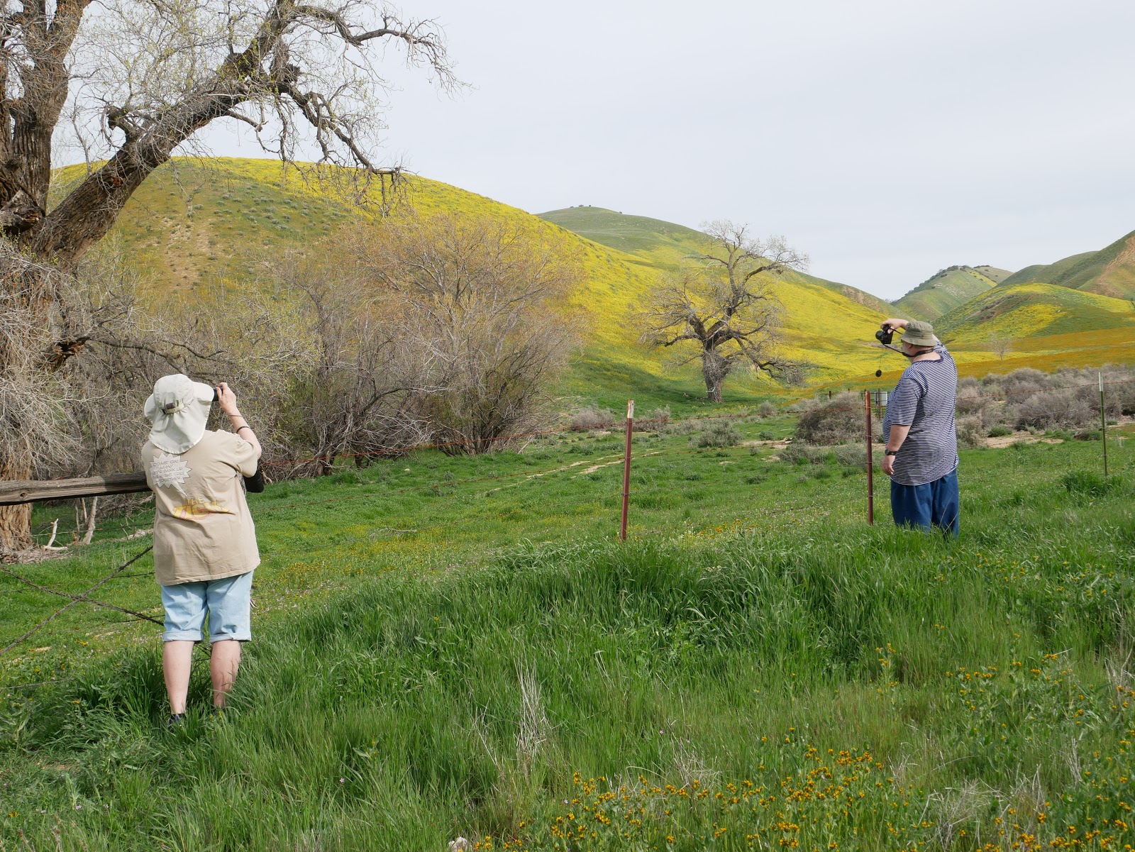
We follow Elkhorn Road round a bend to find a landscape of hillsides painted in wildflowers.


Fast-forward to later in the day:  This is a shot looking east toward the Elkhorn Scarp and the Temblor Range.


On this day, we saw little evidence of wildlife, although since the week-ago rains, more than a few little someones had darted across the area.


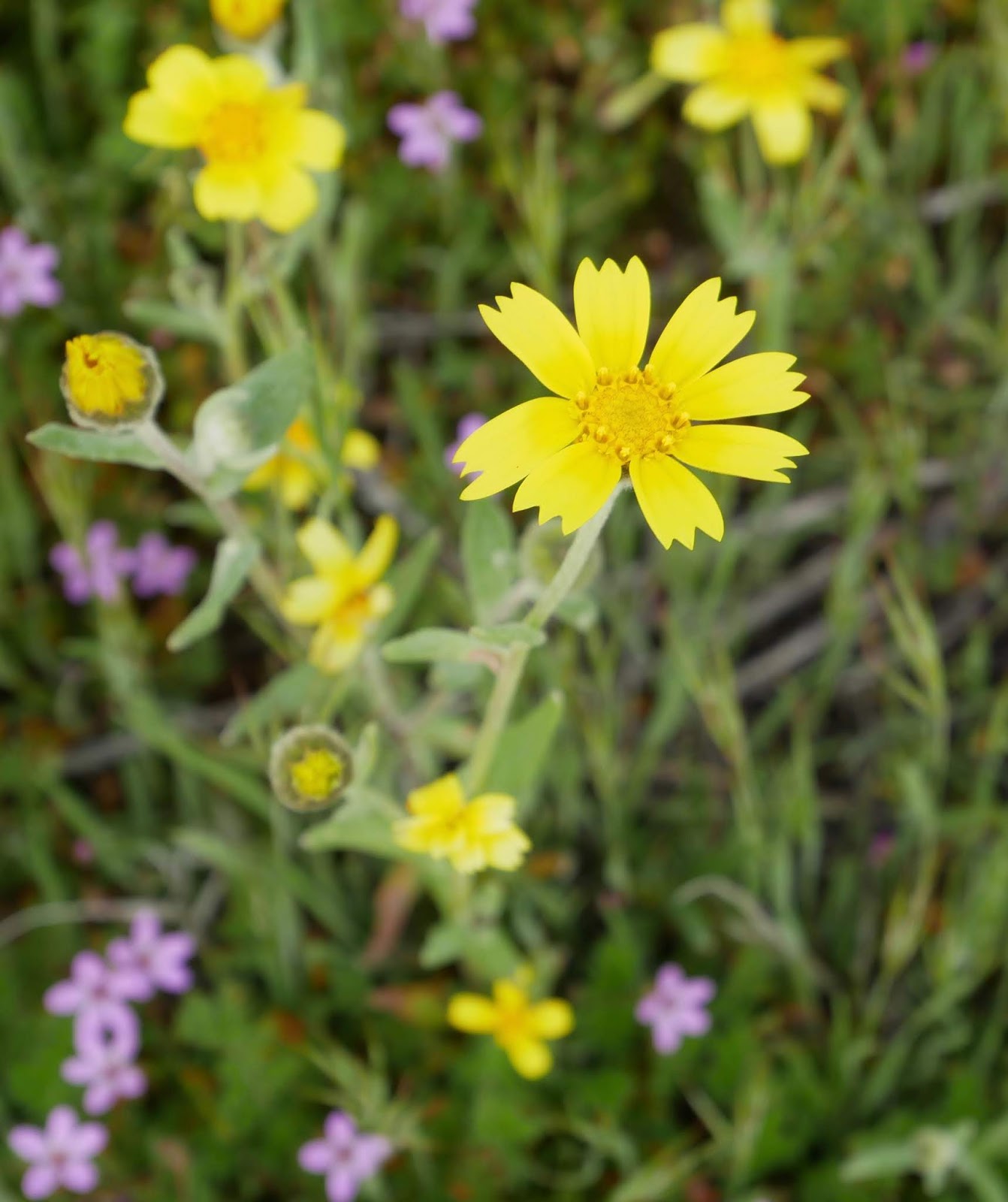
I’m glad the sandstone paw print turned out as well as it did.  My prowess for close-ups of flowers with my new Panasonic leaves much to be desired.


I’m sure travel partners David and Carol were much more successful because they’re both much more patient with their cameras.


I did get lucky once or twice…


…and I did luck out with this little beetle. Many of his buddies could be found in and about burrows dug by unseen rodents.


Until I gain better command of the camera, I’ll need to be content with distant shots of carpeted lowlands…


…and hillsides.


At the south end of the scarp, we make a choice to climb over a ridge and descend onto the Carrizo Plain proper.  Along the way a hazy view of the southern San Joaquin invites pause.


Heading north on Soda Lake Road, we are reminded of the ranching heritage that dates from the early 20thcentury…


…through early mechanized times.


Impressive is the gentle beauty of plain’s floor where in one section the flora will be of one sort and two hundred yards further on, something entirely different.


Makes me wish I knew more about botany.

The Carrizo Plain, bounded on the east by the Temblor Range, the west by the Caliente and the south by the Transverse, was once a great inland sea.  Precipitation falling across the area would flow into a basin that had no natural outlet.


A boardwalk crosses the marsh, but we chose short climb to a lookout point where what’s left of that inland sea – Soda Lake – spread out before us.


Also, before us lay this swath of blue explored by a couple of fellow sojourners.


Too soon, we were on the road exiting this marvelous and relatively undiscovered corner of California.  I left delighted that I’d made this return trip, thinking that I’ll need to come again, once I’ve figured out my camera.  


Any excuse will do.

o0o
Notes and Resources:

Field Guide to the San Andreas Fault by David K. Lynch: Thule Scientific, Topanga, © 2006 & 2014. $40.  Get this while it can still be found!  Lynch provides insight into the geomorphology of the entire San Andreas rift from Brawley in the south to Cape Mendocino in the north.  Lynch provides mile-marker-by-mile-marker highlights divided into 12 day trips where the reader/adventurer can spot evidence of one of the more dynamic aspects of California’s fluid geography.  His trip six – Soda Lake Road to Simmler – served as a guide for our sojourn.  Lynch recommends devoting a whole day to this remote region.  We did.

Peterson Guides:  We carried A Field Guide to Pacific States Wildflowers and Rocks and Minerals as well as a bird book but found that with so much to see and with so many stops to view both flowers and the fault zone, we rarely referenced them.  Still, they were good to have along and it felt good to find a photo of some rusty colored sandstone that matched the bit I’d pinched between my fingers.

The Bureau of Land Management offers this link:   https://www.blm.gov/visit/carrizo-plain-national-monument  I’d urge readers to check out this site, bearing in mind the cautions and regulations contained here-in.

Carry water!
o0o

Today’s Route:  From Buttonwillow on I-5 exit CA 58 west through McKittrick – lots of oil extraction in the area, but, curiously, NO GAS available – and over a pass in the Temblor Range toward California Valley.  Left on Seven Mile Road (unpaved); almost immediate left on Elkhorn Road (also unpaved). Essentially on top of or near the fault, follow Elkhorn Road a distance we neglected to measure (nearly 30 miles) to a junction found just as you enter a mountainous region to the south.  Bear right and climb steeply over the range making sure you pause for a grand view of the southern San Joaquin Valley before descending into the plain.  


Turn right onto Soda Lake Road (mostly unpaved) and travel north-northwest to Seven Mile Road.  Head east to complete the loop.

Wednesday, August 12, 2015

ALL SMOKE, NO MIRRORS


The Aborted Nor-Cal – Oregon Tour

The idea was simple.  Coordinate with a colleague on his ride north from the Bay Area to his home near Seattle.  Spend a night in Redding, and then head to Bend, Oregon, with a detour around Crater Lake.  Part there and return south, exploring some of the few Southern Oregon and Northern California roads I’d ridden only once, or better yet, only heard about:  OR 62 from Crater Lake along the Rogue River to I-5; CA 3 from Yreka down past Trinity Lake with, perhaps, a side trip out to Ramshorn Summit; Alder Point Road from Bridgeville through Blocksburg and down to Garberville. 

I looked forward to taking pictures of old barns and old bridges and old trucks, pausing at bergs and farmsteads one may fly over yet never see; places where people make a living but it’s not clear how they do (dismissing, perhaps, medicinal herbiculture.)


Fire season in the west, much like the presidential campaign season in the US, never really ends.  Two years ago, a wild fire coughed choking smoke over our home in Sonoma’s Alexander Valley at Thanksgiving.  This year, in mid-July, a wild fire across the ridge in Lake County would grow to over 70,000 acres – 20,000 of them in a three-hour run one Saturday afternoon.  And it wasn’t the first one in the area this go-round.

Meeting up with my riding partner in Winters (after lunch at the incomparable Putah Creek Café) we bolted up Interstate 505 to Dunnigan and I-5 toward the Shasta-Cascade Wonderland hubbed in Redding.  The further north we traveled, the more the blue sky deteriorated into a yellow-gray haze.  He on his Stelvio and I on the GSA, we reveled in being able to legally bat along at 75 mph through the smoky, 100-degree Sacramento Valley. 

At a stop in Orland, we were informed that a bunch of lightning caused blazes were torching the far northern part of the state.  Cal Fire’s central command post was set up at the Shasta County Fairgrounds in Anderson.  Perhaps we could worm our way in and take a look at the current incident map.


“How can I help you fellas?” The Public Information Officer (out of Riverside County) wore a snappy blue uniform – one that looked as if someone engaged in cutting much line hadn’t been wearing it.  The PIO extended a hand and welcomed us with a smile.  Pointing to the incident map, there were, indeed, over seventy active fires within this camp’s sphere, stretching from Del Norte County in the north into Napa and Solano Counties in the south.  It didn’t look good.

The Coast Range had been seared by a wave of dry lightning a few days prior and another wave was forecast to swing north this very evening.

After a gracious forty minute tour of the camp, covering personnel, sleeping arrangements, shifts, the difference between state and federal fire fighting protocols and technical improvements to assist the guys on the line, the PIO concluded:  “You’ll want to get out of Redding early tomorrow in case more of these things blow up.”  He swept his hand over that incident map.

We would hightail it in the morning.


Or would we?

I own a Moto Guzzi: a hoot to ride and, in my 11,000 miles of ownership, bulletproof.  But for longer trips, I take the BMW.  My riding partner’s ride of choice is his ’09 Guzzi Stelvio.  Quirky looking, tank a bit too small for long distance runs, but infused with Italian passione.  He loves the thing.

Unfortunately, some of that passione decided to burst through a blown gasket just beneath the left side cylinder head about fifteen minutes north of Redding that next morning.  The fix may have been simple and the tow to the nearest dealer would be covered by insurance, but the nearest dealer was 194 miles to the south.

The rest of my trip would be solo.


There was no reason for me to continue to Bend so I retraced steps to Redding.  The fire incident map had indicated that CA 3 from Yreka was closed south of Hayfork due to wildfire.  Alder Point road was closed at CA 36 at Bridgeville due to wildfire, which proved a moot point since I wasn’t going to be able to get to 36 via 3.

Recalling that incident map, I knew CA 299 was one of the few roads traversing the Coast Range that would not be closed by fire activity.  I opted to take it from Redding through Weaverville to Arcata on the Humboldt County coast. 

A 30-minute roadwork delay afforded the opportunity to visit with a distance running coach from Utah State U. and a young couple from Iowa – both parties concerned about the area’s thin pall of smoke.  “Unseasonable smoke is pretty common this time of year,” I said.

Beyond Weaverville, CA 299 crests at Oregon Mountain Summit and descends into the Trinity River drainage.  On a normal day, the view from that high point prompts the rider’s pulse to quicken in anticipation of a nicely paved highway twisting in and out of forests, through rustic, tiny villages and along a delightfully tumbling wild river.

Today?  Only smoke.

In cool mornings through early afternoons, airborne particulates settle into lowlands, valleys and canyons.  As the day warms, the smoke rises and dissipates.  The day hadn’t warmed yet.

The further west I drove, the thicker the smoke became to the point that, if there were city blocks in the area, you couldn’t see further than two of ‘em.  I stopped for a picture near Burnt Ranch wondering if they might rename the place “Reburnt” or “Twice Burnt” Ranch by the time these conflagrations played out.


Near Blue Lake, now following the Mad River, the valley opens to the sea.  On-shore breezes mercifully pushed against the burgeoning blanket of smoke.  Thus, the air was a clear and lovely azure.  Deep breaths yielded only freshness, no cinders.   

The ride south on US 101 into Eureka emphasized just how strongly that cross wind, on-shore breeze can blow.

A quick shower to rid myself of soot.  Dinner near the historic wharf, followed by an evening walk along the waterfront, then a night’s rest at the Eureka Inn.


Morning of the final day dawned gray and drizzly, a pleasant, fresh change from the hot, murky interior. 

South on US 101 and west on CA 1 led me to a crystal view of the Pacific over the rugged Mendocino coast. 

Dubbed the Shoreline Highway, California’s State Route 1 is one motorcyclists, worldwide, come to experience this most entertaining road. 

Along the way, riders enjoy quaint fishing villages, stately redwood stands, inviting strolls to the bluffs and views that reach beyond forever.   

I dawdled in the clean maritime air, and stopped for a plate of clams at Noyo.

Ninety minutes inland and I would be home.


Whether this loop at this time could be categorized as a great trip, I’d have to offer doubts, given the conditions.  But all in all, it was an excellent experience; just one I’d rather not repeat any time soon.

© 2015
Church of the Open Road Press

Tuesday, January 27, 2015

WILLIAM B. IDE ADOBE – A VISIT TOO LATE


It ain’t what you don’t know that gets you into trouble.
It’s what you know for sure that just ain’t so.
- Charles F. Kettering


For as long as I have lived in northern California, Interstate 5 has run the length of the state.  I’ve utilized it dozens of times flying toward adventures in the Siskiyous and points north in Oregon and Washington.  Just one exit beyond Red Bluff, after a crossing of the Sacramento River, a posted sign reads William B. Ide State Historic Park.  Racing by time after time, I think to myself, “I’ve gotta stop there and check it out.”

On this day I would.
(c) California State Parks


William B Ide arrived in California in 1845. He proved to be a pivotal figure in the historic “Bear Flag Revolt.”  Our state was once known as Alta California, a Mexican territory.  The Californios of the region became intent of separating from Mexico’s governance due, in part to its distance (Mexico City) and its indifference to the Mexican citizens that lived here.   

A handful of Americans who’d come to settle in the Great Central Valley – Ide among them – traveled to Monterey to embrace the separatists and play roles in establishing California as an independent republic in June 1846.  As a result of a rousing speech he delivered, Ide was declared President of the republic.  That circumstance would stand only until the United States declared war on Mexico in July 1846 – about 22 days.

The history I’d learned and the history I subsequently taught my Fourth Graders fifty miles south in Durham, CA, was that Ide was an up-river settler who became the only President of the California Republic – and that he lived just up the road in Red Bluff.   “You can even visit his house, up there,” I advised my kids, although I’d never visited myself.

On this day I would.


The William B Ide Adobe State Historic Park is located on a bluff overlooking the Sacramento River.  


Listening to the river whisper by, the soft breeze through the oaks and the occasional twitter of some native little brown bird, it is easy to imagine oneself settling in this bucolic piece of heaven about a hundred and seventy years back.  The land was rich and fertile, the river rife with salmon and game roamed within easy range of even the most primitive firearm.  Just add Maureen O’Hara…

I like to drop into the visitor center first, pay my fare and check out any exhibits there in – and thus be better informed about that which I will experience outside.

“I’ve been meaning to come here for about fifty years,” I chatted with the young docent on duty.

“Well it’s good you finally made it, but I’m afraid you’re about eight months late.”  He saw the quizzical look on my face.  “Did you read about us in the paper?”  I shook my head.  “Well, did you happen to get a look at the oak tree?”  Again I shook my head.  “Well go take a look.”

East of the visitor center a about fifty yards stands the trunk of a five hundred year old oak, pared back to about two stories in height.   

A few feet further on, wrapped in industrial grade plastic and surrounded by a temporary fence, is the shell of what once was called the Ide Adobe.  I walked around the building unable to capture a decent shot of what it once was.

“Yep,” the young man said, “Storm blew through last March and most of the tree collapsed on the building.  Wiped out the roof and the floor but the walls seem to be okay.”

Roof Detail from Smokehouse
The State Park System is restoring the adobe, but it will take some time.  My once-again-lesson-learned has to do with putting off those places you’d like to visit for another day.  I’d missed this one by a mere eight months.


A footnote to this whole visit is that Ide probably never lived at the adobe.  He likely lived further down-river as he spent quite a bit of his political career as a bigwig down in “Colusi” County.  There was a river ferry just down stream from the adobe known as Ide’s Crossing.  The state or the locals assumed – according to the docent – that William B Ide had something to do with that enterprise or at least its name.  But no record exists to suggest anything other than simple coincidence regarding the name.  On top of that, no one is quite sure if the photos of Ide are actually photos of Ide.  Pictures of two different men are on display at the park, both purported to be William B Ide.


Resources:

A stop at the park is well worthwhile, even in its current condition.  It is a pleasant break and a short jaunt off I-5 north of Red Bluff.  California State Park System information on the Ide Adobe may be located at: http://www.parks.ca.gov/?page_id=458

© 2015
Church of the Open Road Press