Showing posts with label Tehema County. Show all posts

Friday, June 28, 2024

LASSEN PARK – BLAST FROM THE PAST II

episode 2 in a weekend with extended family


Amazing how quickly a yesterday from 60-plus years ago seems like a yesterday from well… yesterday.


Candi, Brother Tim and I were driving the Lassen Park Road – it having opened for the season only a week before – stopping for alpine views, conversations with others and looking for sites for a picnic lunch. 


A few miles up the twisting route, we paused at a point to view the ragged rim of the ancient Mount Tehama. Stunted pines, dwarfed by elevation, roots cloaked in patchy snow, clung to basalt. In the distance lay Mill Creek Meadows and, beyond that, the azure, blue pool of Lake Almanor. 


A couple drove up on a black Harley Davidson, so I had to engage. A week out from Green Bay, Wisconsin, they were.  I told ‘em I was from nearby Chico. “Chico?” the man exclaimed. “We used to have one of your Chico boys in the Pack.” “Aaron Rogers,” I confirmed, “graduate of Pleasant Valley High.” “Yeah,” the man laughed. “He moved on to the Jets so we don’t care about him anymore.” Ahhh. The people you meet on the road.


State Route 89 is the highway that serpentines its way through Lassen Volcanic National Park. My pick for the most beautiful road in California, it runs from Mount Shasta City (Siskiyou County) to Topaz (Mono County) winding through volcanic legacy, high deserts, pristine lakes, tourist meccas and granite outcrops.  Beat that anywhere, I dare ya. Annually, from after the first significant snowfall of autumn until mid-June, the road is closed through Lassen ~ the 8500 foot summit too much for plows and blowers in those reaches. 


Everything seems so fresh and new just after opening. Two alpine ponds rest just below the summit. Lake Helen and its mate were both crusted with ice, but the parking lot to the Lassen Peak Trailhead was cleared. The cars of at least two dozen intrepid souls rested while their owners braved the mostly snow covered route to the 10,400 foot top. Not today for us.


At Kings Creek meadow we found the footing a bit dicey, so on to Summit Lake where we would pause for some crackers and cheese and fresh fruit. Or would we? The steel gates to the camping area were securely locked. Picnic area unavailable. I turned the Subaru around to retrace our steps. But Candi said, essentially, Not yet. Another U-turn (looking like damned out-of-state tourists) and we pressed a mile or two further.


Beginning on page 151 of “Eden, Indeed,”* in a recollection about my delivering foodstuffs to a fire camp on the Mendocino, a brief back story is offered about a 12-year-old me, on the Twin Lakes Trail in Lassen Park, hiking with Dad. 


A ‘call of nature’ prompts me to stray off trail when I find myself peeing into really warm duff.  Something wasn’t right and at Dad’s command, I hightailed it down the trail to the ranger’s outpost near where he’d parked his Jeepster.  


Almost before I could get the words out about the hot duff, the ranger grabbed a Pulaski, told me a little something about the nature of lightning strikes and raced up the trail.  I stood in the vacant ranger station not knowing what to do or where to go until Dad clambered down the trail lugging my Kelty Pack along with his own.


That mile or two further found us at the old outpost.  I walked across the parking area to the Echo Lake Trail that now had a wooden walkway crossing the meadow.  The place names on the directional sign were all familiar.  


I’d hiked to most of them and a carousel of memories circled in my head.  The bridge was new.  The sign was, too.  But everything else was exactly the same.

Almost.  Across the meadow beyond the bridge, the pine forest was a collection of denuded stumps and spikes, victims of 2022’s Dixie Fire which started forty miles away over ridges and down canyons. 
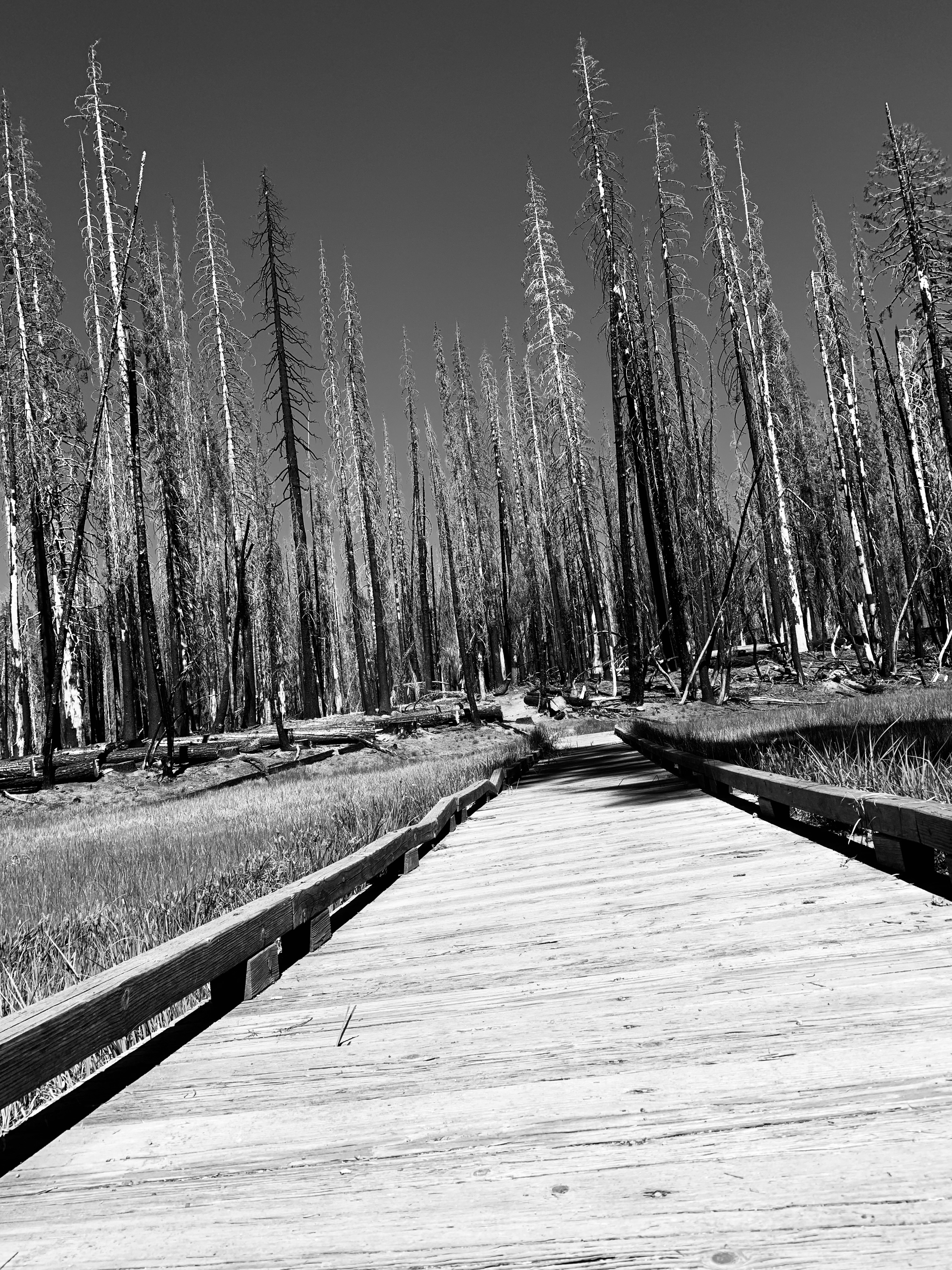


Standing next to the trail sign I recalled the ranger and his Pulaski and wondered if this might have been the result sixty years before had a young kid not ventured off the trail to pee.  Or was that just yesterday?


© 2024

Church of the Open Road Press


* Don’t yet have your copy of Eden, Indeed?  It’s still available to order from your local independent bookstore (it's in the Ingram-Spark catalog) or through your favorite online source. (The Church of the Open Road always recommends doing business with the former...)

Tuesday, July 31, 2018

THE LESSON FROM THE SKINNERS MILL FIRE (CIRCA 1977)

A Church of the Open Road mini-memoir

In the summers between my first three or four years as a classroom teacher, I picked up work as a truck driver for a small, north state freight outfit.  It was great! In ten weeks of trucking I could make about 2/3s of what I’d earn in nine months of teaching.  Normally, my gig was to deliver local freight to small towns in our area, but, once, when a wildfire broke out, I was tapped to haul perishable groceries from Willows, California to a fire camp about 30 miles west of Corning.
          
“You’ll get a ton of hours, but you won’t be offered any overtime,” the freight dock foreman told me mentioning something about the contract Peters Truck Lines held with the Forest Service.  “Toss in a sleeping bag and catch a little rest whenever you can.”

The run from Willows to fire camp was about sixty miles, thirty of which were on freeway, the rest divided between paved secondary and dirt forest roads.  The bobtail I drove was refrigerated, packed with steaks and eggs and milk and OJ and whatever produce firefighters would need to rekindle their energy and rejoin the fight.  Someone loaded the truck, I didn’t, and when I got to camp, inmates unloaded it.  All I did was drive, making the round trip four times in one twenty-four-hour period.
         
Arriving once at dusk, whoever was in charge of the kitchen pulled me from the cab and pushed me to the front of the chow line. “You’re the most important man in camp,” he said, slapping me on the back. “Eat up.” And the largest steak I’d ever seen was unceremoniously draped over the edges of one of the 10” round Chinet® paper plates I’d probably just delivered.  A steaming baked potato was plopped on top.
         
I guess I must have been important because I was invited to stand and eat with a group of uniformed US Forest Service firefighters twice my age, one of whom appeared to be in charge.  
         
“You know, kid,” he began, “In school, I betcha you teach about the fire triangle.  Well, it’s actually a square.  There’s four elements: heat, fuel, oxygen and the California Division of Forestry.”  He paused and then said, “You take any one of those things away and the fire goes out.” His colleagues laughed at the joke they’d probably heard a hundred times before.  Then he got serious, “Son, thank you for bringin’ up all this food.  I don’t know how long we’re gonna be up here. You see, we aren’t gonna put this fire out.  We don’t put fires out.  They go out.”  

No one was laughing this time.

Over the intervening forty years, our fire seasons have morphed from a finite early August to mid-October to something more like year-round. In that time, I’ve learned that fires die when there is no more fuel to burn, like when the wind shifts driving the fire line back over the already burned area, or when it arrives at a lake or sea shore; or when a cooler, more moist air mass moves in over the area or when a storm drowns the damned thing.  Change of the seasons meant that an August fire might be contained until a late September rain doused it.  
         
In our contemporary times, fires – big ones – have been sparked in July, June, May and even April.  And those rains may not come in October.


This smoky morning, as I pick up the paper and see the orange tint of the smoke-filtered sun on our freshly painted house, I am reminded of the words of that old Forest Service Fire captain…

We don’t put fires out.  They go out.

…and realize that what rainy season we might hope for is over three months away. 

© 2018
Church of the Open Road Press

Tuesday, January 27, 2015

WILLIAM B. IDE ADOBE – A VISIT TOO LATE


It ain’t what you don’t know that gets you into trouble.
It’s what you know for sure that just ain’t so.
- Charles F. Kettering


For as long as I have lived in northern California, Interstate 5 has run the length of the state.  I’ve utilized it dozens of times flying toward adventures in the Siskiyous and points north in Oregon and Washington.  Just one exit beyond Red Bluff, after a crossing of the Sacramento River, a posted sign reads William B. Ide State Historic Park.  Racing by time after time, I think to myself, “I’ve gotta stop there and check it out.”

On this day I would.
(c) California State Parks


William B Ide arrived in California in 1845. He proved to be a pivotal figure in the historic “Bear Flag Revolt.”  Our state was once known as Alta California, a Mexican territory.  The Californios of the region became intent of separating from Mexico’s governance due, in part to its distance (Mexico City) and its indifference to the Mexican citizens that lived here.   

A handful of Americans who’d come to settle in the Great Central Valley – Ide among them – traveled to Monterey to embrace the separatists and play roles in establishing California as an independent republic in June 1846.  As a result of a rousing speech he delivered, Ide was declared President of the republic.  That circumstance would stand only until the United States declared war on Mexico in July 1846 – about 22 days.

The history I’d learned and the history I subsequently taught my Fourth Graders fifty miles south in Durham, CA, was that Ide was an up-river settler who became the only President of the California Republic – and that he lived just up the road in Red Bluff.   “You can even visit his house, up there,” I advised my kids, although I’d never visited myself.

On this day I would.


The William B Ide Adobe State Historic Park is located on a bluff overlooking the Sacramento River.  


Listening to the river whisper by, the soft breeze through the oaks and the occasional twitter of some native little brown bird, it is easy to imagine oneself settling in this bucolic piece of heaven about a hundred and seventy years back.  The land was rich and fertile, the river rife with salmon and game roamed within easy range of even the most primitive firearm.  Just add Maureen O’Hara…

I like to drop into the visitor center first, pay my fare and check out any exhibits there in – and thus be better informed about that which I will experience outside.

“I’ve been meaning to come here for about fifty years,” I chatted with the young docent on duty.

“Well it’s good you finally made it, but I’m afraid you’re about eight months late.”  He saw the quizzical look on my face.  “Did you read about us in the paper?”  I shook my head.  “Well, did you happen to get a look at the oak tree?”  Again I shook my head.  “Well go take a look.”

East of the visitor center a about fifty yards stands the trunk of a five hundred year old oak, pared back to about two stories in height.   

A few feet further on, wrapped in industrial grade plastic and surrounded by a temporary fence, is the shell of what once was called the Ide Adobe.  I walked around the building unable to capture a decent shot of what it once was.

“Yep,” the young man said, “Storm blew through last March and most of the tree collapsed on the building.  Wiped out the roof and the floor but the walls seem to be okay.”

Roof Detail from Smokehouse
The State Park System is restoring the adobe, but it will take some time.  My once-again-lesson-learned has to do with putting off those places you’d like to visit for another day.  I’d missed this one by a mere eight months.


A footnote to this whole visit is that Ide probably never lived at the adobe.  He likely lived further down-river as he spent quite a bit of his political career as a bigwig down in “Colusi” County.  There was a river ferry just down stream from the adobe known as Ide’s Crossing.  The state or the locals assumed – according to the docent – that William B Ide had something to do with that enterprise or at least its name.  But no record exists to suggest anything other than simple coincidence regarding the name.  On top of that, no one is quite sure if the photos of Ide are actually photos of Ide.  Pictures of two different men are on display at the park, both purported to be William B Ide.


Resources:

A stop at the park is well worthwhile, even in its current condition.  It is a pleasant break and a short jaunt off I-5 north of Red Bluff.  California State Park System information on the Ide Adobe may be located at: http://www.parks.ca.gov/?page_id=458

© 2015
Church of the Open Road Press

Thursday, October 16, 2014

CALIFORNIA’S NORTHERN CASCADE: MOUNT LASSEN AND MOUNT SHASTA


Day 1 of the Volcanic Legacy Tour of California and Oregon


In about 1959, my folks prodded my seven-year-old butt up to the top of a snowy Lassen Peak.  At the time it seemed like torture.  My toes frozen inside some raggedy Keds, I don’t remember enjoying anything on the way up.  Going down, however, without an inkling of how dangerous it might be, sliding down a three hundred yard snowfield made the day quite worthwhile.  There would be no snow this day.

I try to make it back every year, but it had been a while since my previous visit.  It had also been years since I’d done a road trip with my brother: he on his classic 90s era BMW 1000 GS.

Eschewing the glorious Deer Creek Highway from Chico, we bolted up CA 99 to Red Bluff.  California’s State Route 36 east of Red Bluff tilts from the valley floor and in about 36 miles rises into the volcanic ridges and floes of the Cascades.  Passing through the climatic zones on the October ascent is exhilarating.  I can’t remember the last time I’d ridden this route from farmland to forest.

Turning north on CA 89, we enter Lassen Volcanic National Park, one of the state’s best-kept secrets.  There are plenty of hikes, plenty of smells and lots of interesting flora, fauna and geology.  One could spend weeks.


Once in the park, we paused for a bike portrait with Broke Off Mountain in the background.  Broke Off is a better hike that Lassen Peak.  Longer, but a more gradual climb.  And when you get to the summit, you have a nice view of the park’s namesake mountain.  Mom and Dad pushed my butt up that one, too.


Inside the park, CA 89 winds past fumaroles, alpine lakes and ridges made of volcanic mud and ash.  Sparse vegetation, if it gains a foothold, grows slowly in these 8,000-foot climes.  Tremendous views are offered south to Lake Almanor, west to the Sacramento Valley and always of the mountain.

We pause at the Bumpass Hell trailhead and then at Summit Lake, recalling family adventures from decades ago.

But, as on too many of my trips, our goal was further up the road therefore our pauses were too brief and our cameras used too little.


CA 89 may be one of the prettiest roads anywhere in America.  It breaks off from US 395 in Mono County, crosses the spine of the Sierra Cascade and ends up uniting with I-5 in Mount Shasta, CA.

We travel through Hat Creek Valley, past McArthur/Burney Falls State Park and stop for a roadside photo-op once the Queen frames herself at the end of a straight stretch.

McCloud, CA is a moment off the highway.  The old lumbering town still has remnants of the rail line that brought timber to the mill and products to the mainline.  Brother Bill’s wife was born at the hospital there.  We find the old building is being restored.


The McCloud Hotel is a fine place for a romantic evening, but since I’m with my brother, we choose to stay at a Best Western in Mount Shasta.  An evening walk around town affords a peek at the Queen as dusk settles.


We retire wishing we’d covered a little less ground and smelled just a few more of the roses along the way.

o0o

Note to Self:  When riding with someone else I often wish I’d stop to take a picture as I whiz past something historic or beautiful, but don’t because I don’t want to hold the other guy up.  I need to quit worrying about that.

© 2014
Church of the Open Road Press

Thursday, November 3, 2011

REMEMBRANCE

Forester Gil Murray

DURING MY BRIEF TENURE as principal at Chester Elementary School I was, perhaps, the only person in town who had not been touched by Gil Murray. A year before I was appointed, Mr. Murray left home to assume the position listed in the plaque. Many, many somber days passed after he opened the Unabomber’s awful package in his office in Sacramento.


Gil was a Little League baseball coach, an ardent steward of the environment, and much loved in the community of Chester. I regret two things: That I never met the man and his untimely and uncalled for demise.

This little monument is located in Deer Creek Meadows on the old Lassen Trail a few yards west of Highway 32.


FITTING THAT WE SHOULD CONSIDER what we believe to be important and how we choose to express it.

© 2011
Church of the Open Road Press

Thursday, October 27, 2011

AUTUMN ALONG THE DEER CREEK HIGHWAY

California State Route 32


ON AN UNBOOKED WEDNESDAY in October, I braved the forty-degree morning and ventured up Highway 32 in search of the colors of fall. Highway 32 between Chico and its “T” at Highway 36 proved to be my growing up playground – as a kid and as an adult. Deer Creek ran full, but the flood was of memories.


ONCE UPON A LONG TIME AGO, a fire lookout stood at a point known as Windy Cut. Dad and brother and I would find this a perfect locale for "relief" after a day traipsing around Ishi's habitat with Dad in the lead, telling stories and convincing us we were not lost. Great memories.

It was here, in about 1995, that I took a nap after a final visit with Dad at the Twin Pines convalescent hospital down in Chico. Turns out, as I rested, he crossed over.  I always stop at the Windy Cut when taking Highway 32 - if only for that relief and to remember.


THE STEEL BRIDGE across Deer Creek is the halfway point between Chester, where I lived for a time, serving as Principal of the Elementary School, and Chico, where I grew up to the extent I grew up. This picture, taken in 2011, could have been taken in 1955. A fishing trail follows the north west side of the creek downstream into the Ishi Wilderness area.

Many family hikes traced the edge of Deer Creek having found parking at the bridge. Sometimes with friends. Sometimes, just us. Dad would tell stories of the Yahi Indians and of Ishi, then thought to be their lone descendant, who swam in these waters and speared salmon. I often thought of myself standing on a rock with a hand-hewn spear tipped with obsidian and harvesting a rich pink specimen. My brother suggested I’d probably starve first.

When I was a kid, Mom referred to this as Wild Rhubarb. Not ever wanting to question her, I have not looked this up in Sierra Nevada Natural History, the Church of the Open Road’s primary “Bible” for all things natural. If anyone does and finds out something different, let me know. That way I can be exposed to the truth and still be free of questioning Mom.

Backlit, this black oak leaf captivates.


AT DEER CREEK MEADOWS, just southwest of 32's T with 36, the Lassen Trail still exists. I stumbled across it this day and thought that soon, I'm going to ride that cut-off from stem to stern. Peter Lassen’s road started out past the Black Rock Desert in Nevada, crossing into California at Fandango Pass, thence traversing the barren Modoc Plateau. Bearing south, Uncle Pete found the headwaters of Deer Creek and followed it west, more or less, to the valley floor. This length of graded gravel certainly looks inviting.

More info on the Lassen Trail.

In late October, the bucolic Deer Creek Meadows rest parched and browning, only a few weeks shy of being blanketed by next winter's snow. The sky has a misty, high-country autumn tint. The air is flavored by pinewood fire smoke from the great rock fireplace of a nearby lodge. And a creek runs through it.


ONE EXPLORATION OF THE RUGGED LAND of the Yahi ended up, somehow in the “town” of Mill Creek. Perhaps Dad saw the sign on Highway 36 and wondered what was down there. That happened all the time. I was in the back seat of his 1950 Willy’s Jeepster and all I recall was an immediate and rather abrupt turn at the great white barn.

Fifty years ago, we came to a little resort that, I discovered, still stands today. Hidden behind the lattice at the right-hand end of the porch is an ice cream cooler that beheld a delight on a stick: vanilla ice cream on the inside and frozen root beer on the outside. I think Dad paid fifteen cents for it. Maybe only a dime. Never the less, as a nine-year-old, I knew what heaven tasted like.

This day, the Mill Creek Resort closed at 1:00 PM. It was 1:10 when I arrived.

I would have been disappointed that the little inn was closed – and was – until, rounding a bend on state route 172, the light played perfectly against the golden leaves of another black oak. I realized that this was one of many good days of riding I've enjoyed this season. The root beer ice cream pop would just have to wait. Perhaps another fifty years.


OH, AND…

I took this only because it appeared to be a government sign not destroyed by someone with a six-shooter - rather destroyed by Mother Nature who may well believe that the whole planet should be considered a preserve.

It’s tough to disagree with Mother Nature. Probably bad policy, too.

© 2011
Church of the Open Road Press

Monday, November 8, 2010

THE “ROMANCE” OF BRUFF’S CAMP: PONDEROSA WAY – TEHAMA COUNTY


I am informed that it is difficult travelling down the Sacramento Valley, on account of the moisture; and that there is no river conveyance and the stream is very rapid, and obstructed with bars and snags. And that the mines are exceedingly unhealthy.

J. Goldsborough Bruff:
October 21, 1849 in
Gold Rush


ON THE ROAD, in the saddle, riding through hills and forests and glens and weather, it is easy to romanticize those who have gone before. Those whose evidence of passing is a mere place name and, perhaps a foundation overgrown with vines or a rock chimney devoid of house. We travel in and out of these remote places dreaming daybreaks of melted mist and days ends of fiery sunsets, which give way to carpets of stars across a milky way. In between these dawns and dusks: placer mining rich with gold scooped from the stream bed, or boundless pastures upon which cattle graze, or clear pines felled for posts and rails or cabin walls. A Maureen O’Hara-type has a hot meal waiting and a few terse words that enhance the sexual tension. Pretty soon the credits roll: Republic Films.

A fellow named J. Goldsborough Bruff suggests things probably weren’t quite that way.


Poyle spent another weary day, chasing deer in vain. Only observed a few, at a distance. Baked a cake with some mildewed pinola…
November 18, 1849

ALONG THE PONDEROSA WAY somewhere between the old Campbellville Lookout and Payne’s Creek, where the Lassen cut-off – having traced the narrow divide between Deer Creek and Mill Creek – intersects it, there’s a Forest Service sign marking Bruff’s Camp. I don’t have a picture-taken-personally because it’s been forty years since I went that way. A revisit is on my short list of trips yet to take on the BMW.


BRUFF HAD POSITIONED HIMSELF as president of the Washington (DC) City and California Gold Mining Association. This assembly of 65 incorporated to journey west in late 1848. Many historians consider Bruff’s writings to be some of the best sources of information on the Gold Rush. Most compelling are the months he spent in the foothills of the Sierra / Cascade. Perhaps 30 miles from early settlements in the Sacramento Valley, yet with supplies and wagons deteriorating, he sent his party forward while remaining behind to care for the group’s sundries. His encampment along the Lassen Trail proved to be a highway for many emigrant parties and, as he waited his own rescue, he assisted others with their passage west. Assistance meant providing game; constructing shelter out of wagon remains; ensuring the fire was always burning; ministering to the ill and burying the dead. Deep in the evening of October 31, an aged oak collapsed…

A large limb, capable of making a couple of cords of fuel, had to be cut off, and then the long heavy trunk pryed with levers and rolled off… …and there lay a shocking sight – An aged, grey headed man and his grown son, with their hips buried in the ground, their ghastly eyes turned up in death!
November 1, 1849


THE PARTY THAT WAS TO RETURN for Mr. Bruff, did, indeed – however they came only for the provisions they’d left in his care. They did not return with the horse he had loaned. He did not leave camp with them owing to the fact that he carried “journals, drawings and mineral specimens” he chose not to leave behind. His former colleagues refused him further assistance. So Bruff dug in. He weathered drenching rains and low snow. He loaned goods to passers-through, chronicling meetings with good people (a Mrs. O’Brian and “two curly-headed girls”) and selfish…

A couple of men ask’d me for the loan of a camp-kettle and axe as they were about to cook a meal close by. I readily loaned them the articles & they made fire against a tree trunk. I had worn a gum poncho & tarpaulin hat, but the rain held up for a while, and I took them off and threw them into my tent, while I went to a camp near by; on returning, the strangers were gone, with the loaned articles, my poncho and hat. I hope their gratitude will meet its reward.
November 6, 1849


FOR SEVERAL WINTER-SEASON MONTHS, Joseph Goldsborough Bruff lived in the foothill hinterlands just east of the Northern Sacramento Valley until he and two others were rendered so weakened and ill that they had to abandon camp and follow Lassen's cut-off into the lowlands.  He ended up at Lassen's Rancho near the confluence of Deer Creek and the Sacramento River where he was called upon to make good on the debts of others in the company who preceded him to the outpost.  Behind him, he left the bones of covered wagons, the bodies of those who could march no further and the scattered skeletons of promised riches - riches that seemed so real to the legions who ventured into the western wilderness back in '49, '50 and beyond.

I THINK ABOUT BRUFF as I explore the gold country canyons of the American, the Yuba, the Feather and of Butte and Chico Creeks and those lesser streams that flow west from the Sierra into the valley. I think of him when I see a place name or an overgrown foundation or a naked rock chimney. I think of Bruff and am reminded that the settlement of the west was perhaps ten percent romance and ninety percent hard luck.

####

NOTE:  Like Simpson Camp on the Mendocino National Forest in the Coast Range, I can no longer locate Bruff’s camp on any of the following: The US Department of Agriculture’s Lassen National Forest Map, the US Department of the Interior Geological Survey Quadrangles, or DeLorme’s California Atlas and Gazetteer. But I’ve been to Bruff’s Camp and I’m going back some day.

RESOURCES:

Bruff, Joseph Goldsborough, Gold Rush; the Journals, Drawing, and other Papers of J. Goldsborough Bruff, Captain, Washington City and California Mining Association, April 2, 1849-July 20, 1851. Ed. by Georgia Willis Read and Ruth Gaines. With a foreword by F. W. Hodge. California Centennial ed. New York: Columbia University Press. 1949

© 2010
Church of the Open Road Press