Showing posts with label Shasta County. Show all posts

Friday, June 7, 2024

FIELD NOTES FROM FIVE DAYS ON THE MOTO GUZZI

 …back in the saddle again… 

It was the multi-day motorcycle tour I absolutely needed to have.  A trip to my favored old stompin’ grounds up north would rekindle my distance riding spirit but highballing on the I-5 freeway is not the best use of an Italian masterpiece such as the Guzzi.  Still, when one crests that hill on the four-lane some thirty-plus miles north of Redding and sees the welcoming arms of Mount Shasta – the Queen of the Southern Cascades – the breakneck pace of the interstate seems worth it.  A few moments off the bike to take in the view is in order.  


Shasta would be riding on my shoulder for much of the week’s adventure.  (Four days later, I would be gazing at her when my cell phone pinged to alert me about a highly anticipated jury verdict.  I’ll always know the answer to the question “Where were you when you heard about…” It’ll be Mount Shasta.)


Whenever possible, I overnight in McCloud at the historic McCloud Hotel.  Brother Randy from the Pacific Northwest and I meet up there for a stroll around the business district and the company town housing. 

Always a delight to see what some folks have done to dress up some of the vintage company town homes of eighty to hundred years back.  Dinner is usually at the Sage Restaurant at the hotel and sleep is comfortable, relaxing as the old place fills dreams with the sounds of the creaking floor joists and the musty aroma of history.


 Sadly, the Sage Restaurant was unable to open for dinner dining this year for lack of staffing.  We were looking forward to a nice bottle of wine and a perfectly cooked filet.  Breakfast, however, was nicely turned out, setting up a pleasant second day on the road.


The Volcanic Legacy highway crosses Lake Britton near the train trestle from that frightening scene in the movie “Stand by Me” and leads us to Burney Falls State Park. 


The entrance station ranger offered to let me in for free if I’d allow him to take a spin on the Guzzi. He’d recently given up riding his Gold Wing.  I handed him my key but, ultimately, he shrugged and soon I was out nine bucks.  I couldn’t help but admire his giddy appreciation for the Guzzi.


 There’s a glorious rest stop / scenic overlook just off State Route 44 east of Old Station.  Situated halfway between Shasta and Lassen, it is always a go to.  Both summits seem close almost enough to touch.


This day, two sojourners from Austria were making their way from Mexico to Canada on the Pacific Crest Trail. Brother Randy engaged with them as they shared details of their thus-far adventure.  


My pal talked about his daughter’s semester in Austria and asked the kids to please feel free to call when they made Snoqualmie or Stevens Pass in Washington – still months away for them – tempting the hikers with hot showers, comfortable accommodations, and good food and wine.  I’ve bedded down many a night at Randy’s hostelry when riding up that way and can attest to the quality of the goods and services there offered.  Ahhh… The people you meet on the road.  Hopefully the couple will take advantage.


 Our route to Quincy took us along the east shore of Lake Almanor, where I lived for a couple of years when serving at the principal of the local elementary school.  Here, a favorite turnout with a view of Lassen in the distance…


An hour further south we took a side trip to visit the old Paxton Hotel.  That waystop is recounted in a previous post.  https://thechurchoftheopenroad.blogspot.com/2024/06/old-haunt.html


 The cozy and rustic VRBO cabin selected outside of Quincy would serve as a good layover spot.  A robust creek serenaded all day and all night.


The layover day allowed a trip to Bucks Lake passing the cabin (well, grand chalet) of a childhood chum.  The place looks just as I remember from back in the early 60s.  Well preserved.  Nice work!  Down the road a piece is the dam ~ a spot worthy of a portrait of the bike ~ but what caught my eye was the proliferation of Dogwood blossoms.   


Harbingers of lovely mountain summers and always among my favorites!


Afternoon would find me riding solo up the Quincy/LaPorte Highway into snow country with the road only plowed the day before.


Geographers tell us that there is a distinct difference in the geomorphology of Sierra Nevada and the Cascades. That granitic uplift to basaltic outflow shift is somewhere in the Feather River watershed.   


Sucker for a picture of an old steel bridge that I am, this one span crosses the Middle Fork of the Feather.  This might be that place.  If not, there's a nice swimming hole below.


Heading north the following day, we pass through the historic northern mine town of Greenville, devastated by the horrendous Dixie Fire of 2021.   


That visit is also shared in a previous post. 

  https://thechurchoftheopenroad.blogspot.com/2024/06/lessons-from-fire-footprint.html


 Retracing our steps back to McCloud and beyond, we are reminded that any road taken in the other direction is, essentially, a different ride.  The mountains, the meadows, the forests – all stunning and fresh, leading us to our final night in Dunsmuir.  The little berg nestled along the upper reaches of the Sacramento River is an historic whistle stop on the old California Northern (later Southern Pacific; currently Union Pacific) route. 


Café Maddalena is a favored restaurant there.  I stumbled in several years back to sit at the only seat available and enjoy perhaps the best meal on the road I’d ever had.  The café has become a must-stop treat anytime I’m in that neck of the woods.  


Unfortunately, the economics in this itty-bitty mountain town could not support the business.  Apparently, we were only a week or so late as its doors had closed permanently though the website was still up.  Such a disappointment.  Hopefully Café Maddalena will rise again.  We’ll keep checking back.


 Three or four years ago, I thought I’d tired of multi-day tours on the motorcycle.  I gave up a substantial model to downsize, but the urge never fully went away.  Does it ever?  A year ago, I upgraded to this 850cc Moto Guzzi V85tt touring model.  Distinctive and good looking.  Powerful enough.  Light.  And it eats both sweeping curves and twisting ones.  This past week’s ride makes me happy I’ve gotten back in the saddle.


See you on the road. 


Footnote


Around lunch time on the first day, I rolled into Willows.  In a bit of a rush, I fell back on a habit I’d developed long ago when my between-teaching summers were spent delivering local freight. In fact, that first summer, I earned nearly as much driving truck as I did as a teacher for the year.  Almost made me turn my back on a career in education.  Then one of the old-timers (52 years old) didn’t make it to the dock on Monday.  Died the Saturday before on the sixth green.  Heart failure.

     I was reminded of this as I parked the Moto Guzzi next to a bobtail like the one I’d driven.  Upon receiving my order (two Burrito Supremes and a small soft drink, speaking of asking for heart failure), I spied the driver: a lanky young red headed man with a full beard.  Probably weighed in at about 135 pounds.  As he stuffed his face, I thought, My God!  That was me fifty years ago!

     I ate my lunch and didn’t talk to the kid but about five miles up the freeway it occurred to me that I might have suggested: “The money is good right now, but the lifespan is short. Go for big dreams.”  But I didn’t.  

     The least I could have done was offer to pay for his taco.


© 2024

Church of the Open Road Press

Thursday, October 12, 2017

AUTUMN ON 89 – PART 3


Into the Rain Shadow


Here is the precept this series of three posts will set out to prove: California’s state route 89 is among the most beautiful highway routes in the entire country. 


On a chilly October morning, it’s tough to get out of bed, especially when being nuzzled by a canine heater.  The cozy cabin at Sorensen’s with its knotty pine interior seems an inviting place to hibernate until April.  I asked about this at the front desk but was informed that the resort is pretty much fully booked year round.

Given a distance yet to travel if we were to complete our exploration of California’s State Route 89, an early morning constitutional seemed in order.

The early rays of sunlight illuminate this juniper…

… but in the sheltered mini-canyon of this brook, rocks were layered in ice.


At Woodfords, Highway 89 heads south to Markleeville, seat of Alpine, https://alpinecounty.com/ California’s least populous county and perhaps the only county seat lacking full service banking.  Through town, the road rises to another of those 1800s scenes…


… then follows the East Carson River, another grand playground for the fisherpersons among us…


… where the autumn blossoms from roadside sage (?) contrast with the standing deadwood of a two-years-ago wild fire.  Still, a river runs through it.


Monitor Pass feels like little more than a rise, then fall, of the roadway.  It is marked by a weathering stone marker…


… set among aspens growing on either side of the route.


Clearing that copse of trees, it is clear we’ve moved to the rain shadow of the Sierra.  The lush forests of ten miles back are gone, replaced by largely barren hills dotted with stunted pines and juniper and scruffy brush.  Cattle country, if you don’t run to many of ‘em.


Off to the north, a fire lookout perches atop a wind-worn Leviathan Peak.  A rugged dirt road winds up the hillside.  The Subaru begs us to take it.


About two hundred yards short of the top, a substantial steel pipe gate blocks the road.  We disembark for a little hike.


The view from fire lookouts is always outstanding.  Go figure.


I figure out how to do a panorama shot on my Sony pocket camera only to return home to discover that the computer screen wide enough to do justice to the vista has yet to be invented.


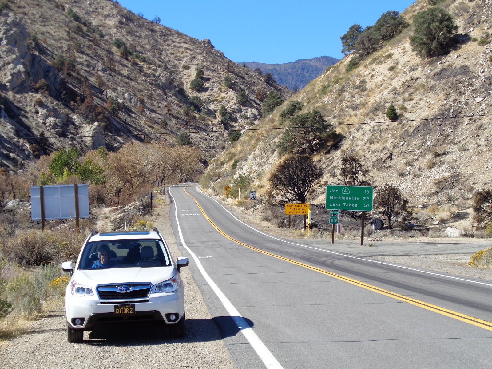
Creeping back down the dirt track and resuming our tour, Highway 89 winds over and around dry, desert ridges, and, in its final few hundred yards, traces a stream course down to the floor of Mono County’s Antelope Valley.

Many times, I’ve seen motorcycle riders throttle through this canyon, ending up on US 395 bearing a grin bright enough that it could be seen through their full-face helmets.  I recall feeling that grin myself after running the route on one motorcycle or another.


But 395 is where this glorious state route ends. 


After more than 300 miles and having visited lumber towns, volcanoes, pristine meadows, snowfields, granite arêtes and countless turns and summits and tastes of history, the premise of the little tour I’d planned held true: State route 89 is among the most beautiful highways in the entire country.

The only question that remains is: How long until I can do this again, heading the other direction?  (…on the bike?)

© 2017
Church of the Open Road Press

Tuesday, October 10, 2017

AUTUMN ON 89 – PART 2


Ishi Country to Hope Valley


Here is the precept this series of three posts will set out to prove: California’s state route 89 is among the most beautiful highway routes in the entire country. 


Fifty-five years ago, Dad was hot on the trail of Ishi, considered the last of the unsullied native North Americans.  Ishi lived in the wilds of both Deer Creek and Mill Creek avoiding contact with the white settlers whose presence caused the demise not only of his Yahi (or Southern Yana) clan, but of all of the continent’s Indian population.  Just a hop, ski and a jump from our home in Chico, Dad would pore over maps and Al and Theodora Kroeber’s work and the journals of emigrants from a hundred years before, trying to discern where and how Ishi and his brethren lived; then with his kids, Dad would strike out into the wilderness to show us where it all happened. 

The one thing I remember is that one summer day, we stopped in at the Mill Creek Lodge where he bought me a root beer popsicle from the freezer on their porch.  Since that day, I’ve always wanted to spend the night in one of their rustic cabins.    This trip, we did.  Recently purchased by a couple of young partners, this off-the-beaten-path hide-away is worthy of a night or two. http://millcreekresort.net/


Highway 89 aligns with State Route 36 in these environs, and our day’s tour would find us motoring east to Lake Almanor, a lovely reservoir that now fills the Almanor Basin. http://www.lakealmanorarea.com/ I’d served at the principal for the little elementary school in Chester some twenty-five years ago, and my own pig-headedness prompted my unceremonious departure from that lovely place. Had I possessed the necessary maturity and professionalism, I’da likely stayed for a career.


Still, Almanor holds a favored spot in my heart for it’s high country surroundings, it’s history of both lumbering and mining, it’s limitless recreational opportunities, it’s clean air and the cleansing nature of it’s night skies.


After breakfast at Anna’s, my favored spot for a slice of Greenville life, and whizzing through Crescent Mills, we veered into the gravel parking area marked by a brown Forest Service sign. 

Countless times I passed a trailhead that I wouldn’t visit until this trip down 89.  Edward, the lab-mix was more than ready to stretch for a bit, and, perhaps lift a leg, were a black oak or digger pine available for the purpose.

The waterfall on Indian Creek dumps into a delightful pool that, I’m sure, come summertime, is thick with folks enjoying the cool waters.

This day, we receive a glimpse of the fall colors to come.

Above the opposite bank, an historic rail line shooting up toward Fall River Mills now supports both the BNSF and the UP.  I can hear the baleful whistle and the low rumble of truck on track echoing through the canyon.

Not far below is the picturesque Keddie Wye, an engineering marvel on the old Feather River Route from early in the 20th century. http://www.american-rails.com/keddie-wye.html


CA 70 follows the Feather River Canyon between Oroville and Quincy.  In itself, Highway 70 is a classic route.  Dad thought he’d teach me how to drive on, until he realized I couldn’t keep his beloved Toyota FJ-40 centered in 70’s winding lanes.

State Route 89 joins this road at the Greenville Wye, heading east through the Plumas County Seat and past several tiny one-time bergs.  Along the way, we pass a unique 360-degree loop engineered by the Western Pacific to raise the rail line on a two percent gradient necessary to make the line from Reno out to Quincy, thence down to Oroville, a reality.  Another engineering marvel.  Can’t really see it from the road, although it does show up on the Subie’s GPS map in the dash.


At Blairsden, 89 breaks south through the historic lumber town of Graeagle – now given over to second homes and golf courses – with a cool general store and fine little café and a string of galleries and shops occupying repurposed 100-year-old company town houses.

South of Graeagle we depart 89, foregoing a trip through Calpine, to enjoy the pristine pools of the Lakes Basin, ringed in lofty granite. http://www.lakesbasin.com/ Gold Lake, itself, is a treasure and the Sierra Buttes are as stunning as any peaks in the range, except few people visit.  That said, the rustic lodges that dot the region are often booked a year in advance.

A previous hike to the lookout atop the Sierra Buttes is recounted here: http://thechurchoftheopenroad.blogspot.com/2011/08/nice-ride-nice-hike-sierra-buttes.html The hike is a dandy and the view a great reward.


In order to rejoin CA 89, we bear east at Bassett’s junction on CA 49 and cross Yuba Pass.

Just over the summit is a view spot filled this day with road repair equipment. 


Normally one gets a stunning view of the Sierra Valley with its pasture lands rimmed in worn, rolling ridges.

Reconnecting with our route, we pass this classic road sign…


…and get a taste of an old west that may still be alive.


Perhaps the most taxing length of State Route 89 is the section that runs through Truckee, down past Squaw Valley and along the west side of Lake Tahoe.  Even on a mid-week day in October, the traffic is heavy and, in some place stop-n-go. 

Truckee’s historic downtown has not been so touristified that it isn’t still a delight – just ask Paul McCartney who has been known to stand in with the band at the corner tavern.  Sadly, we’ve always missed these occasions. 

The UP’s California Zephyr runs on these tracks – although it used to run up the Feather River – and taking this train from Roseville over Donner for an overnight in Truckee is a delight.

Squaw, too, with its history of hosting the 1960 winter games is worth a gander.

We didn’t stop until we arrived at Tahoe’s classic view of Valhalla, the tiny island in the middle of Emerald Bay. 


Cut the population and traffic by 90 percent, and the property costs by about five times that, and I’d consider moving here.


The evening of the second day found us at the incomparable Sorensen’s Resort http://www.sorensensresort.com/ in Hope Valley.  A low October setting sun set the aspen leaves aflame…


… the cozy accommodations…


… and a chill we’d anticipate in the morning.  Glad I packed wool.


More on that in our final installment.

o0o

Next:  Autumn on 89, Part 3: Into the Rain Shadow

© 2017
Church of the Open Road Press

Sunday, October 8, 2017

AUTUMN ON 89 – PART 1


Lumber Town to Lassen


Here is the precept this series of three posts will set out to prove: California’s state route 89 is among the most beautiful highway routes in the entire country. 

I’ve traveled the whole thing, segments at a time, but never dedicated an entire road trip strictly to exploring 89.  October, as the aspens change after the earliest of snows, would prove the perfect time to check this off the bucket list.  Having gushed about the scenic wonders to my spouse, the trip would become a family adventure with Candi, my life partner and Edward the lab-mix piling into the Subaru and heading for the high country.  Enrico, the Yamaha, would wait forlornly in the garage.


Mount Shasta, California’s second highest peak, serves as the beacon at the northern-most end of state route 89.  Departing I-5 at Mt. Shasta City, 89 courses eastward through verdant pine forests, past the sno-park at Snowman’s Hill toward McCloud, an historic lumber town where we’d spend our first night.

Exiting the modern conveniences of the Subaru and stepping into the lobby of the McCloud Hotel [https://mccloudhotel.com/] is like being transported back in time about 125 years.  The interior is paneled in pine from before pine was turned into panels.  The furnishings are antiques you can sit on.  Scrumptious dinners are offered in season, but we were out of season and walked a block to the Old Meat Market Restaurant and Tavern – located in the town’s historic mercantile – for a steak.


A big fan of historic graveyards, a special one exists at the north end of Quincy Street up toward where the mill used to churn board foot upon board foot.  With a little imagination one can hear the puffing of the Shays as logs enter the mill and finished product leaves.


After the mill shut down, folks figured a tourist train through the forest might revive a bit of the economy.  Lovely thought, economically unsound. 


Now the rolling stock simply rests for eternity, I suppose.


The McCloud River is one of many watercourses along the route.  A tributary of the Sacramento, the McCloud offers dramatic waterfalls, peaceful swimming holes and a symphony of water music accompanying soft pine-scented breezes. 


A paved forest service road provides a six-mile detour though lush standing forest land and past several campgrounds and historic sites. 


Well-groomed hiking trails link Lower, Middle and Upper Falls.  I’d ignored this side road too many times.  Not today.


Crossing Dead Horse Summit, we enter the Pit River watershed.  (Along with the McCloud, the Pit is also a tributary of the Sacramento, their confluences being just upstream from Shasta Dam.)


McArthur Burney Falls State Park [https://www.parks.ca.gov/?page_id=455] offers a grand and easy trail – suitable for children, but not for Edward – looping Burney Falls with signage speaking to the continual evolution brought about by the power of flowing water.


I can imagine spending forever there, just watching the tumbling cascade do its work.


Hat Creek is renown as a Mecca for fly fisherpersons. [http://www.troutsource.com/fly-fishing/river/hat-creek] A county park on state route 299 just a few miles east of 89, offers respite from the road and a great place to picnic.  Also, cell coverage. 


We picnicked and awaited an important phone call.

Back on 89 a curious sign that I’d not seen before, read “Hat Creek Observatory.” An arrow pointed east.  “Why not?”

Down a lane and through a lockable gate, we travel across a high, October-arid meadow.  Rounding a bend, it is as if we are about to be greeted by ET. 
  

Just as the lobby of the McCloud Hotel transported us 125 years back, now we were being jolted ahead about a century. 


“The Allen Telescope Array is a response to one of the most enticing sirens…” begins the description of this perfectly placed remote sensing station.  [http://www.seti.org/seti-institute/project/details/general-overview]


A placard tells us that the radio telescopes are “carefully placed at random,” a phrase that only makes sense if you see ‘em.  To quote the late Huell Howser, “That’s a-MAAA-zing!”


Lassen Volcanic National Park is located in my growings-up backyard.  [https://www.national-park.com/welcome-to-lassen-volcanic-national-park/]  I’d probably hiked all the fore-country and backcountry trails before I left high school.  It had been too many years since my last visit and this one would be too short.


I’d first visited a site known as the “Devastated Area” – so named because this was the path of destruction when the side of the mountain blew out in 1915 – some forty-five years after the event.  I recall seeing cinders and tiny saplings struggling to take hold in an area set about with oddly strewn boulders that had been blown from or pushed down the mountainside. 


Now, some fifty years later (102 since the eruption) the saplings have grown and explanation needs to be offered as to why this area was once called “Devastated.”

Lassen Peak is a sentinel.  Highway 89 serpentines through the park…


…affording view after view of this magnificent mountain, perhaps the southern-most promontory of the Pacific Northwest’s Cascade Range.


Never are we too far removed from evidence of the area’s molten past…


The light of a long day of travel, which proved to be too short, fades.  We dig in at a rustic cabin on historic Mill Creek – there’s a story here – intent on resting and recharging and readying ourselves for tomorrow’s adventure…

o0o

Next:  Autumn on 89, Part 2:  Ishi Country to Hope Valley

© 2017
Church of the Open Road Press