Showing posts with label State Route 20. Show all posts

Monday, April 29, 2019

DINING DESTINATION IN LAKE COUNTY, CA

Upper Lake’s Blue Wing Saloon

file photo from an earlier lunch visit
Two-thirds of the way between Chico, where we spend the occasional Sunday with grandkids, and home in Cloverdale we find the Blue Wing Saloon. Located on Upper Lake, CA’s short and historic Main Street, it has proven to be our dinner-stop location of choice on this drive.  Locally sourced meats and greens, the bison burger is a lunch-time favorite, but last night’s (a Sunday) grilled pork chop was perfect with a glass of Lake County Pinot.

But wait!  There’s more! We happened in around 7:00 PM to unexpectedly find a trio – piano, bass and voice – soothingly performing standards from the great American songbook.  Local musicians, each, they added an already scrumptious dinner in the historic bar/dining room.  The pianist who claims to farm weeds (not weed) just north of town played Hogey Carmichael’s “Stardust,” the only song my dad ever tried to play on the piano [insert flood of memories here] while the classically-trained emigre from Japan “back in the 70s,” she told us, provided the lyrics. Thus, once home I found I’d been offered the soundtrack for a night’s dreams.

Next door – across a cool and lovely outdoor dining venue – is the historic and rebuilt Tallman Hotel. A grand option given the wide selection of whiskeys behind the bar at the Blue Wing that I couldn’t sample knowing I had a seventy-minute drive yet to come.

Rather than being just a place to break up a long drive,  the combination of these two establishments will make an oft-overlooked and oft-passed-right-through Upper Lake a destination for us in the very near future.

o0o

The Blue Wing has a comprehensive wine list, micro-brews on tap, a continually changing seasonal menu and great service – all in an historic setting that makes you feel as if you’ve been transported back in time a good hundred years or so.  Check it out…  https://tallmanhotel.com/blue-wing-saloon/  


© 2019
Church of the Open Road Press

Saturday, July 7, 2018

DAY TOUR OF FIRE COUNTRY – A RETURN ENGAGEMENT

Riding through devastation and rebirth
in California’s Coast Range

One of the great positives of the changes in climate some say we are experiencing is that, in most of California, riding season is almost twelve months long. Unfortunately, so is fire season. September’s big blazes began in June this year.

Sonoma, Lake and Mendocino counties have experienced more than their fair share of wild land fires over the past few years.  Only a couple of months ago, a section of hills around the Dry Creek wine growing valley erupted. In October 2017, Santa Rosa lost 4,000 homes and 40-plus lives. Lake County’s Cobb Mountain resort area was lit up in the summer of 2016; the town of Lower Lake that fall.  Over Thanksgiving weekend of 2015, the hills surrounding the Geysers geo-thermal units smoldered for days.  More than the turkey, that day, was smoked.

I’d checked things out about a month after the October disaster.  Now nearly eight months later, Enrico, the Yamaha, and I decided to take another look at the aftermath.


Departing US 101 at Mark West Springs Road a few miles north of Santa Rosa, I am immediately greeted by a forest of standing chimneys.  (I so want to photograph this orchard of masonry but, like before, feel doing so invades the privacy of those who’d lost so much. Thus, I refrain.)  Continuing into the once-lush Mayacamas Range, the vegetation is now seared away as are the houses once shielded from passers-by.  Only their foundations, chimney and a few scraps of twisted metal remain.  

Mark West Springs Road sweeps along Mark West Creek and over and around denuded hillsides now cloaked in the golden grasses of summer.  Rebirth had occurred – subtle, but a start.  It proves to be a nice ride this day, but I can picture residents clogging that windy route deep one October night as the firestorm rolled out of the east like a fiery boulder at the beginning of an Indiana Jones movie.

Passing the Wildlife Safari exotic animal exhibit, I am reminded that the owner, that terrifying night of the Tubbs Fire, saved every critter in the park using only garden hoses linked end to end, screwing them together by the light of the approaching flames. His residence, however, didn’t make it.

The road dips in and out of the fire zone.  Ridgelines of standing scorched trees appear with some turns, with other twists of both highway and fate, green meadows, pasture lands and unscathed houses stand as if nothing had happened.  The whims of wind and fire, I think.

In Calistoga, I stop at the roastery to purchase my supply of the whole bean that “wakes up Napa County.” Across the street a fine breakfast is offered at the historic Café Sarafina.  A bookstore, a bicycle shop, several boutiques and tasting rooms make this a pleasant stop – although I don’t taste when I’m on the bike.

California’s State Route 29 forms Calistoga’s main street.  South of town, one would venture into the heart of the Napa Valley where, even on a good day, the traffic can slow to a crawl.  North, Route 29 corkscrews out of the valley affording tantalizing over-the shoulder glimpses.  As the elevation gains, I pass through Robert Lewis Stevenson State Park, a mecca for hikers and cyclists beneath a canopy of redwood and madrone.  I’m thinking I should have packed a snack and taken a stroll.

Out of the forest and over a rise and I enter the higher pastures of Lake County.  The wonderfully engaging twists of the route from Calistoga remind me why Lake County never received rail service.  Construction through steep and narrow canyons and over rocky ridges proved too daunting.  The pavement, however, offers a graceful experience for the me and the big Yamaha.  Cresting that rise, I view the denuded tops of ridges that ring the upper reaches of the Putah Creek drainage: Fire scars from two, three, sixteen and perhaps thirty years ago.  

State Route 175 curls away from Route 29 at Middletown heading up to Cobb Mountain and, until two years ago, the Hobergs Resort. In the aftermath of the 2016 fires up that way, sections of Route 175 has been resurfaced and some homes rebuilt.  Rusted derelicts remind me of what once was.  Some vegetation is beginning the slow process of regeneration.  As massive as was that conflagration, just moments down the highway, I enter a cool pine and fir forest as lush as anything one might see in the Sierra Nevada 90 miles to the east.

Route 175 rejoins 29 just south of Kelseyville, one of several California sites bearing the surname of a brutal Indian slayer from the 1850s.  His wife (or sister-in-law), history forgets to tell us, created the original Bear Flag that was raised of Sonoma in the 1840s.  State Route 29 skirts the west shore of Clear Lake, the California’s largest fresh water pond, ending at State Route 20 near historic Upper Lake.  

Looking well north beyond the end of the little town’s Main Street, evidence of a decades-old burn area catches my eye, but that’s not why I’m pausing here.  Upper Lake boasts the Blue Wing Café, home of one of the best bison burgers on the planet.  Garden seating invites me to linger, and, were I not on the motorcycle, the selection of on-tap brews would be more than tempting.  Perhaps some future evening will find my bride and me lodging at the historic hostelry next door.

State Route 20 is a busy east-west crossing of the Coast Range.  On it, I wind past the picturesque Blue Lakes.  A mile or two short of Route 20’s interchange with US 101, I divert onto “Road A,” hopping over a ridge and descending into Redwood Valley.  This area was torched the same October night as the huge fire that scarred Santa Rosa. Lives and homes were lost here, as well, just not as many as a few miles south.

I wheel past several lettered roads until I find Road J.  Heading east, I check on the site of a friend’s home that’d had burned to the ground that night.  Oddly, the fire had placed a fiery footprint on his house but left the one fifty yards away unscathed.  Two-and-a-half months ago, a buddy and I had planted some olive trees near the ashes of the house.  This day, those trees seem to be doing fine and evidence of a rebuild can be seen through the fence.


For the most part, fire is a natural occurrence.  Even after the worst of wild fires, rebirth is almost immediate.  It will be a personal goal to ride this route through fire country every six months or so to see how things – both natural and man-made – evolve.

o0o

Today’s Route:  Exit 494 from US 101, east on Mark West Springs Road which becomes Porter Creek Road. Side trip:  Franz Valley Road to Franz Valley School Road (windy and interesting) back to Porter Creek just west of Calistoga. State Route 29 through town then north to Middletown.  (Great twisty pavement!)  Left on SR 175 through Cobb and Hobergs eventually merging back onto SR 29. North on SR 29 to SR 20, right one mile to Upper Lake, left onto historic Main Street.  Continuing: West on SR 20, right on Road A, right on East Road, head north as far as you want.  (You could end up in Willits!)  Backtrack on East Road, follow signs to US 101.

© 2018
Church of the Open Road Press

Tuesday, June 19, 2018

AN ENGINEERING MARVEL OF EARLY LAST CENTURY

A visit to Van Arsdale Dam

Today’s little adventure finds me locating the Van Arsdale Dam – one of only two on the entire Eel River Complex.  (Note that the Eel River watershed is the third largest in all of California.)  Also known as Cape Horn Dam, it and its powerhouse became operational in 1908.  I’ve been wanting to see this since we moved to the area a few years ago.

The dam itself seems like quite the early 20thCentury engineering marvel.  Built in concert with Scott’s Dam which impounds Lake Pillsbury 15 or 20 miles upstream, the pool itself is relatively small.  Water cascades over the stair-step face on the dam providing a nice soundtrack to a morning summer ride.  I can only image the roar during high water seasons knowing that the Eel has a propensity for washing out rail lines and wiping out towns further downstream.

The water held in Van Arsdale Reservoir is diverted through a tunnel to Potter Valley four miles to the south.  A powerhouse stands somewhere at the north end of that valley, but banjo music, increasing in volume over the hum of Enrico, the Yamaha’s motor, prompted me to turn back as the road wound into the pretty remote country and turned to gravel. Location of the powerhouse was not marked on the map I carried.

A small network of canals provides for the irrigation needs of ranchers in the beautiful and relatively remote Potter Valley, but much of the water channeling through supplies the Sonoma County Water Agency which contributes to the growth of towns along the Russian River from Ukiah south and west.

Non-diverted water remains in the Eel twisting through remote and rugged canyons until emerging at the Pacific Ocean near Fortuna.  On-going arguments are offered that without the diversion from the Eel to the Russian, farming and growth from Hopland to Healdsburg would be stunted.  With the diversion, however, in low-flow years, as we have experienced during this on-going drought, downstream salmon and steelhead fisheries on the Eel suffer.

No act of human engineering – no matter how marvelous – comes without some costs or compromise. As licensure for the Van Arsdale project comes up for renewal in the near term, it will be interesting to see what, if any, changes are in the offing.

o0o

Today’s Route:  From CA 20 between US 101 and Upper Lake, look for signs and exit north on Potter Valley Road. Head north.  Just as the road turns west (at the store) turn right on Eel River Road.  The road climbs out of the valley at the north, corkscrewing through oaks and diggers offering expansive views but few, if any, places to safely stop for a photo. Bear left at the top-of-the-hill fork and wind about a mile or so down into a valley and left again onto Van Arsdale Road.  The dam and CA Fish and Game facility is on the right but fenced.  Nobody answered when I knocked at the door.  Walking back up the hill, I could see the fellas at work monitoring stream flow and capturing water samples.

Return? Bear left at the fork and following Eel River Road for about two miles.  At the junction, a right turn will carry you up the Eel River Cut-off back to the fork at the top of the hill.  Continuing straight (east) will take you along the deepening canyon of the Eel, then, skirting a ridge, up to Lake Pillsbury.  A loop can be made from there down to the community of Upper Lake in Lake County.  (Get lunch there at the Blue Wing Restaurant!)  A nice road for heavier dual sports.

This little ride was a good early morning jaunt, affording me the opportunity to check something off my bucket list.

© 2018
Church of the Open Road Press

Saturday, October 17, 2015

REDWOOD ADVENTURE: CHAMBERLAIN CREEK WATERFALL TRAIL


In the Jackson State Demonstration Forest

It used to take forever to get from Willits to Fort Bragg on CA 20.  As a kid, that was the last leg of our twice-yearly trips from Chico to the coast, and the thirty-three miles indicated on the map seem to consume a half a day.  That’s because, as a kid, I was only interested in getting to the ocean – and shopping at the five and dime on Franklin Street.

Now, while I still enjoy the whisper of the surf and dinner at Noyo, the means to the end are becoming more intriguing and worthy of pause.

Looking for a place to walk Edward the lab-mix off leash, I stumbled across a web link to the Jackson State Demonstration Forest.  (See notes below.) At mile marker 17.3 on CA 20, a well-graded dirt road (number 200) follows Chamberlain Creek leading north into the redwoods.  I’ve probably passed this intersection a hundred times.  Road 200 winds along creek-canyon walls and through groves of redwoods.  Were it not gated about six miles in, one could follow it all the way to the California Western right-of-way near North Spur.  When dry, the road is easily passable on a road-oriented motorcycle, but logging operations are active from time to time, so use caution.


The trailhead to Chamberlain Falls is about four miles in on road 200.  There is ample room for parking.  A well-maintained trail descends steeply down the canyon wall, at some points using wooden steps to ensure the safety of the visitor. 

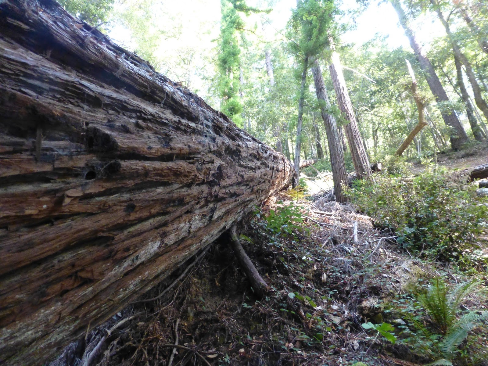
Crossing a downed forest behemoth, we quickly find the creek bottom and, looking over our shoulder worry about the stiff climb out.

But not for long.  There is something in the chorus of silence in a redwood grove that dissolves worry.  Soon we are marveling at the light filtering through the centuries-old trees and thinking about the lucky elves who must enjoy these environs around dusk when no one is present to hear their giggles.

We know they’re here, because we see their houses.


Chamberlain Falls, after four years of sub-normal rainfall, still soldiers on valiantly against the drought.  Looking only as a mere damp section on a solid rock face, one can only imagine the volume of its cascade and accompanying song in a more normal circumstance. 

Exploration is easy because the forest floor is a clear understory, with the exception of the many large trees that lay like God’s Pick-Up-Stix in and around still-established survivors. 

At over six feet tall myself, I estimate the circumference of one giant by standing next to it…

…while Edward explores its length.  He’s happy.

Fears about the steep climb out of this idyllic place are allayed as we encounter a nicely groomed trail that switchbacks up the canyon-side of a tributary, looping back to the road while affording generous views of the enchanting elf-encampment below. 

After forty minutes and about 3.3 total miles (.5 of which are on Road 200) we return to the parking area – refreshed, renewed and excited about what other subtle treasures might be hidden along side the once-interminable highway 20 between Willits and Fort Bragg.

We head home looking forward to more explorations along this route.

o0o

Notes: 

Today’s Route:  US 101 to Willits; west on CA 20 17.3 mile to (unmarked) Road 200; north on 200.  (Landmark: a rest area is on CA 20 is located about 50 yards west and just across the Chamberlain Creek Bridge from the necessary turn-off.)  Follow Road 200 four to four-and-a-half miles to well-marked trailhead on left.  Return:  For a dose of the coast, continue west on CA 20.  Fort Bragg and CA 1 is 18 miles away; south on 1 (along scenic bluffs and through quaint villages) to CA 128 at the mouth of the Navarro River.  East on 128 (through redwoods, wineries and once-funky Boonville) to US 101.

Information on the Jackson State Demonstration Forest from “Mendocino Walks:” http://mendowalks.org/JSDF/JSDF.php


About the Skunk Train (on the old California Western right-of-way): http://www.skunktrain.com/about.html


© 2015
Church of the Open Road Press

Saturday, August 23, 2014

A THOUSAND TINY LAKES


Common “Church of the Open Road” Question:
Where do you suppose that goes?

Best Possible Answer:
I don’t know.  Let’s find out.

We knew we wanted to get to the high country.  We just didn’t know quite where.  We perused one of the Church of the Open Road’s bibles:  DeLorme’s California Atlas and Gazetteer, but with an overwhelming number of options, we simply drove.

Let’s find a lookout, came the suggestion.  There’re always good views from lookouts.  Duh.


Grouse Ridge is a lesser-traveled area in the Tahoe National Forest.  The lookout perched there affords a 360 degree panorama that includes the Coast Range and Sutter Buttes to the west, the Sierra Buttes to the north, the Crystal Range rimming Lake Tahoe to the south east and ridge upon ridge of rugged granite and basalt in between.

Dotted here and there like remnants of God’s tears are tiny puddles, pools and lakes.  You see thousands of them as you fly east out of Sacramento on your way to Chicago or Denver.

Walking down from the trailhead – the problem with any trailhead at the top of a mountain is that you know it will be an arduous up hill getting back to the vehicle – a careful survey through the twisted pines, one sees a blue diamond here and a turquoise one there.

A trail forks off to the right.  Where do you suppose that goes?  I don’t know.  Let’s find out.


Ten minutes on, we arrive a jewel surrounded by granite but curiously sporting a bathtub ring. 

Circling, we find that someone, at some time, felt that industry downstream would be enhanced by governing the flow of water out of this lake.  A dam was constructed.

By regulating the flow, the hydraulic miners of the 1870s could use the power of falling water to blast the overburden off the gold deposits on the Yuba drainage year round. 


Wading through pine mat Manzanita and scaling some granite slopes we come to a view of the Sierra’s crest, but at our feet lay another lake.  Tiptoeing down to it, we circle to where its outlet courses through broken rock and duff.  A few yards further down stream: another pool.

Geographers call these paternoster lakes.  As glaciers scoured round-bottomed canyons, they pushed in front of them cubic yards of rock and dirt and overburden.  When the weather warmed, the ice retreated.  At the endpoint of its descent, the stuff pushed ahead of the ice formed a dam or a terminal moraine behind which a pond formed.  As the cycle repeated, if the ice didn’t flow quite as far down the course, another moraine was formed upstream from the first.  And, along with it, another little lake.  


The high Sierra is ribboned with these strings of lakes.  Some have, by this time some 10,000 years hence, silted in to form meadows, which, in late August, are quite dry. 

Some still rest as clear, cold opalescent gems inviting a wade or a swim.  Each makes a delightful end point for a day hike or an overnighter.

Over any granite rise, as we boulder hop here and there, we might find another little lake and several of her sisters.


Intersecting an established trail, we follow it easterly about three high-country miles to a named lake.
Pines and Manzanita take roothold wherever possible along the shore. 

Granite forming the opposite side thrusts upward. Chunks broken free had tumbled down the steep embankment showing us that nature wasn't quite finished forming the Sierra.

We wore ourselves out this day.  We wore out the dogs, too.  That last two hundred yards up to the parking area damned near did us in.  But in the sound night’s sleep that followed, a videotape of what heaven must be like played in an endless loop.

o0o
Today’s Route: 

From Sacramento east on I-80; West on CA 20; Right turn onto Bowman Lake Road.  (Check out the Sierra Discovery Trail about a mile in.)  After eight miles, right on Grouse Ridge Road; Six miles of quite passable dirt to parking area.  Return:  Retrace route to CA 20 then west to Nevada City/Grass Valley, Auburn and I-80.

Resources:

Sierra Nevada Natural History by Tracy Storer and Robert Usinger.  (I’m on my third or fourth copy.)  University of California Press.

DeLorme’s California Atlas and Gazetteer.  Complete set of topographic maps for the entire state.  DeLorme has a volume for most states.

© 2014
Church of the Open Road Press

Saturday, April 27, 2013

ALTERNATIVE TO INTERSTATE 80 – WESTSIDE OF THE SIERRA


California’s State Route 20 to Nevada City

Sometimes traveling east or west between San Francisco/Sacramento and Reno/Truckee, we just have to get there now.  So we mount up and rocket over the Sierra on Interstate 80.  A freeway, I-80 is designed for people in a hurry – and big trucks.

A pleasant alternative, and a “must do” for folks who may pass this way but once involves California’s state route 20.  This little gem departs I-80 about 20 minutes west of Truckee and by hooking in with CA 49 at Nevada City, thence to Auburn, adds only about an ninety minutes to the trip.  That is, if you don’t stop and if you’re not enticed to explore.

A late April day in the Sacramento area felt more like summer than spring.  A trip to elevation seemed in order.  I mounted Aria, the Moto Guzzi Breva – what a fun bike that is! – and headed east to enjoy this favored route.  After stopping at Brunswick, between Grass Valley and Nevada City for breakfast I zipped all the twenty-seven sweeping miles Highway 20 offered before it conflues with I-80.  There, I U-turned, retracing the route, pausing for pictures and sojourns along the way.


West of the interchange, CA 20 slips downward into the drainage of the Bear and Yuba Rivers. 

Bowman Lake Road offers a nice dalliance into the basaltic northern high Sierra.  A nicely engineered Sierra Discovery Trail begs one to stop and investigate the upper reaches of the Bear. 


Although here, it is more of a brook than a river.


Further up this side trip, we cross the more robust South Yuba.  I turn back at this point knowing what the road will become aware that the dual-sport is resting in the garage.


The area is bisected with flumes dating back to the gold rush.  Miners spared no effort in diverting the natural flow of the area’s rivers into these gradual ditches in order to serve their industry.   


The flumes – modernized and upgraded, still carry water for domestic use down the hill.  They also provide easy paths for a nice stroll.  This is one reason why the CA 20-49 scenic route’ll take more than those 90 minutes.


Back on CA 20, the road descends and then crosses a high country valley that seems lush and green any time of the year that it is not blanketed in snow.


A few miles on, a sign advises of a Scenic Overlook.  (Nice restrooms.)  A paved trail loops less than a half-mile to a view to the north.


A substantial viewing platform reaches over the canyon edge.


Affixed to the railing is a panoramic photograph labeling promontories as near as a stone’s throw and as distant as the Coast Range. 


Roads to places like Relief Hill, Graniteville and Bloomfield are clearly visible through the forest.  In less than a moment, about six adventures are added to the bucket list.


Four or five miles further, we find the little-more-than-a-turnout vista point.  The view is similar to what we’ve just seen, so I end up taking a portrait of the bike…


…but a turn-off to the old town of Washington is marked.  The lusciously paved and well-maintained road sweeps and twists down the canyon to this historic site. 


Cell-phone service?  I doubt it.  Good.


Not far beyond town, the roads improve from pavement to gravel and I think about “the Horse” stabled at home.


One stop I’d not made before was to visit a “Point of Historic Interest.”  A small rectangle of white picket fence encloses the marker of a little boy who was carried across the trail west but only made it this far.


Passers-by leave mementos on the fence.  I suspect someone comes through every now and again and cleans ‘em up.  (Be careful exiting due to accumulations of winter road sand.)

 
A few miles further on and we find ourselves in the “standard metropolitan statistical area” of Grass Valley and Nevada City.  There’s a bit more traffic these last few miles and folks are a bit less leisurely in their approach to the road.


Nevada City and Grass Valley ooze history.  Both have inviting main streets with a nice selection of restaurants, galleries, antique stores and mercantiles.  Both are quite walkable.  Both will contribute to that ninety-minute detour becoming a full day.


Old heliport windsock frame
Today’s Route:  Exit I-80 at CA 20.  27 miles to Nevada City.  To rejoin I-80, head south on CA 49 to Auburn (a pleasant but busy stretch.)  Diversion 1: Right on Bowman Road – the paved portion extends several miles through nicely forested lands, past historic power generating dams and flumes, and by several pleasant reservoirs.  The road turns to gravel and head toward historic Graniteville (west) or over Henness Pass (east.)  Diversion 2: Right on Washington Road; five miles into town.  Great views on the sweeping descent.  Two miles beyond town, the road turns to gravel with the right fork heading up to Graniteville and the left fork (poorly signed) heading through Relief Hill to North Bloomfield and the delightful state historic park.

Note:  CA 20 heads west from Nevada City / Grass Valley through the rolling Sierra Foothills, into Marysville, across the Feather, into Yuba City, below the Sutter Buttes, into Colusa, across the Coast Range, past Clear Lake, joining US 101 to Willets, then on through the redwoods to the coast at Fort Bragg.  One could take weeks exploring all of it.  And probably should.

© 2013
Church of the Open Road Press