Showing posts with label Mariposa County. Show all posts

Friday, April 5, 2019

YOSEMITE: WINTER INTO SPRING

Visiting America’s BEST idea


Only the calendar suggested that spring had come to Yosemite. Winter was not quite finished. Vigorous intermittent cloud bursts were rolling through, shrouding the panorama across from our Yosemite West rental creating a cat-and-mouse display of tumbling cataracts on the canyon wall opposite.  The term shower curtain suddenly had a new meaning.        
         

Descending some 2800 feet to the valley floor, the waterfalls run gloriously full.  El Cap stands like a granite gate keeper, only one with its head in the clouds. 


Mirror Lake, a two-mile walk from parking, both mirrors and mutes Half Dome.


I find myself thinking of Theodore Roosevelt and John Muir and their embrace of the subtle beauties of a magnificent place during inclement weather.  The softness under foot.  The aroma of dampened pine and fir.  The symphony of falling water.  


The near perfect blackness of a cloud-blanketed night.  Annoyances to the contemporary traveler were simply elements of an environmental tapestry these early twentieth century futurists felt worth preserving.

The following dawn: Overnight, spring had bullied that late-winter storm over the Sierra and out across Nevada.  


The air is crisp, the mountains and domes glazed in fresh snow and the forest floor washed clean.
   
      
A hooded Junco pecks at the duff until a Stellars Jay swoops in to claim some sort of grub.  The crok-crok of a distant Raven breaks the silence while a Cooper’s Hawk turns cartwheels on the sub-floor of heaven.

        
Our road to the valley floor (California’s State Route 41) is a patchwork of lush forest and year upon year of burn scar. Fire fighting in the wilderness of the national park, unlike that of the national forests, is a practice of letting nature take its course.  As we pass from one fire zone to another, we can see the succession of life: sprouting grasses, and brave fledgling sprigs of scrub, oak and pine.  It is the rebirth of the forest as God probably intended and as John Muir probably concurred.
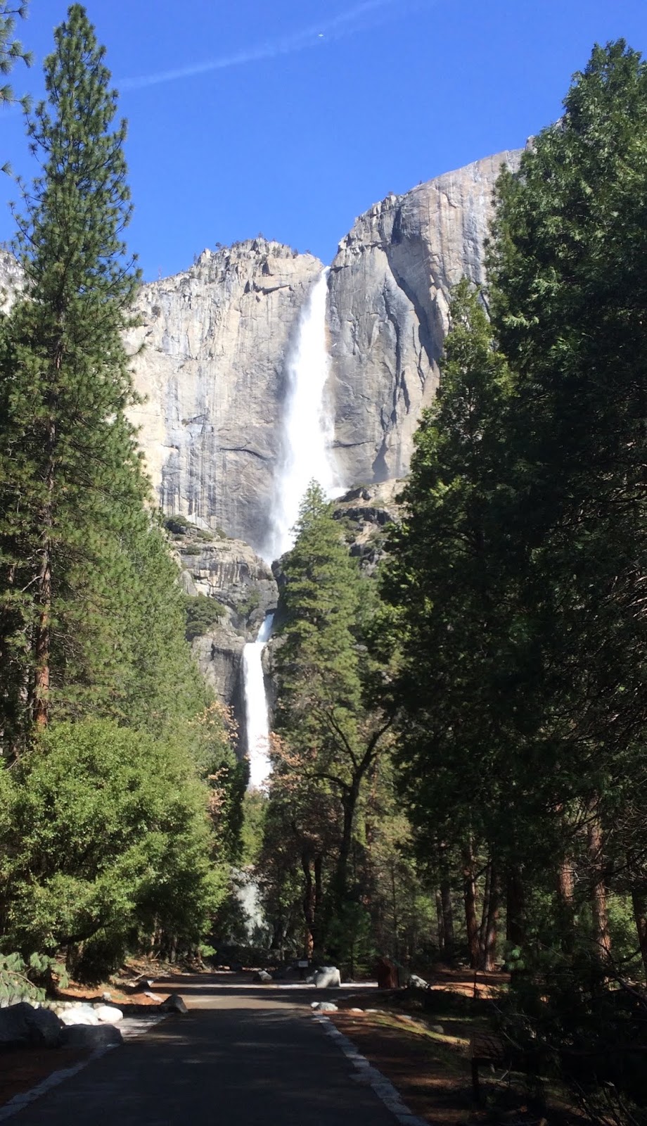
         
Gazing up from Yosemite Valley, Bridal Veil, Yosemite and so many other many nameless cascades leap over cliffs, their falls looking like silver ribbons on a package that, when opened two or three weeks from now, would yield the priceless gift of a wildflower burst in the valley floor. 


At the foot of one tumbling rill, mist dampens my cap and clothes and offers the mid-day sun a palate with which rainbows are painted against a deep azure canvas.

The day would be spent chasing those rainbows and vistas, peering up at the cliffs and down through the crystalline waters of the Merced.

        
To Muir’s pleasure – or perhaps his chagrin – the paths are now paved and choked, in places, with visitors.  


Visitors from around the world whose voices and dialects provide another tapestry for me to consider: a reminder that our National Parks, starting with Yosemite, may well represent America’s best idea.


o0o

More photos…


Muir’s musing.


Morning view from Hwy 41’s Tunnel View.


Unnamed and temporary.


Valley floor awaits spring.


Tenaya Creek crossing.


David Brower’s admonition.


Winter returns.


Our trip to Yosemite was awe-inspiring and too brief.  But evident, after a rather rugged winter and visits to both Yosemite and the Carrizo Plain, is that our National Park system is woefully underfunded.  Signage is down.  Roads and pathways deteriorating.  Meadow restoration, in some places, on hold.  Clean-up after neglectful visits has gone from daunting to undoable.

In a nation that can afford massive budgetary increases to an unaudited military and huge tax decreases to the uber-wealthiest among us, support for our National Parks must not be an afterthought.  These palaces of history, science and beauty must not become available only to the well-to-do. 

Somewhere in our nation is a young John Muir.  He (or she) - no matter the socio-economic caste - must not be denied the opportunity to experience and be inspired as Muir was.  Our parks must be affordable and available to all or they can no longer be referred to as "America's best idea."

© 2019 
Church of the Open Road Press

Tuesday, April 12, 2011

GOLD COUNTRY – MONTEREY COAST LOOP – DAY 2: SONORA TO MONTEREY

Part 2 of a 3-part series.

CO-RIDER AND GOOD BUDDY RANDY BOEK comes from the private sector. Me? Public schools administration: 34 years. In real life, Randy is a leadership development expert. We’ve known each other for well over thirty-five years. Honest with each other to a fault, he lets me know when I’m full of it and, in return, I agree. Over dinner at the Diamondback Grill, we talked about leadership and both the private and public sector’s current dearth thereof. Talking about the day’s riding would have been much more satisfying. The conversation on the evening of the second day would be much different.


WHEN I LIVED IN TUOLUMNE COUNTY twenty years back, Washington Street boasted at least three breakfast joints, The Miner’s Shack, Wilma’s (nee: the Europa) and a place on the ground floor of the Sonora Inn. As things evolve, breakfast seems to no longer be the most important meal of the day and pastries at The Gunn House would have to suffice.

At the crack of 9:00 AM we boarded the BMWs. Choosing a non-state highway route, we wound through springtime on Lime Kiln, Algerine, Twist (aptly named) and Jacksonville Roads. Grasses approached knee depth. Pasturelands were quiet grazed by cattle, sheep, goats and llamas. The cool, dense morning was heavily ladened with the aroma of these livestock. It felt like country. Good country. A scenic overlook at Don Pedro reservoir invited a stop.

(click to expand)
I’ve driven 49 from Sonora to Mariposa in an automobile. It is, at best, a chore. On the bikes it is a carnival. Beyond the San Francisco deeded water units at Moccasin, route 49 continues to snake through foothills for the entire southern length of the Mother Lode. Riding this ribbon of pavement is much like a dance with one delightful move inviting another and another. You hope the music never stops. Vistas to the west take in the broad central valley. To the east, on occasion, we glimpse the high Sierra east of Yosemite.

Gold seekers from throughout the world flocked to the narrow band of rolling hills from 1849 through the mid fifties and beyond. They built towns of brick and timber, many of which have returned to dust, some of which are mere place names and some of which still stand as reminders.

Arriving at Coulterville, we dismount for a close up look at the remnants of our heritage. A massive wisteria climbs through the second story porch at the Hotel Jeffrey, its trunk bigger in diameter than the posts supporting the veranda.

The streetscape includes the abandoned brick general store with evidence of its conversion to electricity. Our heels echo on the boardwalk that may have been first constructed at a time when roads turned from dust to mud in a matter of hours.

Placed at one end of town is Whistling Billy, a narrow gauge tank side engine, workhorse from the mining era through the lumbering era. An example of which was recently discovered up north within the basin of a drained Butt Lake (Plumas County) when the dam was retrofitted for seismic safety.

Mariposa C of C
49 slinks along creek sides, over ridges, through pastures and gentlemen farms. John C. Fremont trooped this way sometime back. Someone named Bagby got a town. Trabucco means firearm. Pendola, we’re not sure. Ophir’s named after the Biblical land of gold.A bootjack was an early implement for boot removal but the town was named after the v-shaped lay of the road or the streams in the area. Mariposa has to do with butterflies. And Oakhurst?

Oakhurst is at the southern foot of highway 49. On a whim, we skimmed along the ridge tops the route takes for its final nineteen miles. I hoped to park the bike under the marker reading California 49 with a rectangular sign reading “end.” There wasn’t one. There was that typical mix of brick and board buildings harkening back a century and a half. We lunched in Coarse Gold.


THE AFTERNOON found us racing westward through the foothills into the orchard plains of the San Joaquin Valley. Almonds. Pistachios. Citrus. And wind. Between Los Banos (so named “the baths” for pools in the area, not “the toilet”) at the east side of the Coast Range, a nasty north wind blew across our track. At highway speeds on route 152, it felt as if at any moment we could be plucked from one lane and deposited in the next. Or across the median. Up through the San Luis Reservoir, each time the road turned or crested a hill, we had to be ready to correct for windblast. Once over Pacheco Pass, the winds abated. Past Casa de Fruita, we pulled over swearing in general, but also swearing specifically that neither of us wanted to ride through such conditions again.

Over the ridges, skirting biker Mecca Hollister, we routed through San Juan Bautista, where Patty Reid’s doll resides at the state park. Names on the landscape are more Hispanic. The hills rolling, green and pastoral. It is understandable why Fr. Serra and his ilk found this land of milk and honey fit for civilizing. If one didn’t save a soul on a particular day, at least the weather would be pleasant.

Miles further, we connected with State Route 1 and, like Fremont a hundred and seventy years back, aimed for Monterey. A sunny spring day had warmed the coastal plain and the air mass above it lightened and rose. Furiously rushing in would be the cold, bitter air from over the Pacific. The winds of the San Joaquin became mere child’s play as we batted down 1, gripping the bike’s saddles in a manner we had not assumed our butts could actually grip, peppered by blowing sand, and greatly concerned that the next gust would blow us into the path of a passing Freightliner.

Google Images
We did not talk leadership at Abalonetti’s on the wharf that evening.


 ***


RESOURCES:

Gudde, Erwin G, California Place Names – the Origin and Etymology of Current Geographical Names, University of California Press, 1949, 1960, 1969, 1998.

Randy Boek (rhymes with “heck” or “wreck”) is a business consultant. He works in leadership development. He believes in the power of people working together toward clearly articulated and commonly understood goals. While much of his focus is on private sector success, there is much that he has to offer leaders in education and other public endeavors. For more information, see http://www.route2results.com/ His insightful blog may be found at http://randyboek.wordpress.com/