Recessions are times when those of entrepreneurial spirit make hay with creative, out-of-the-box thinking. Thus, the Truckee Turnpike Company organized to shepherd frustrated gold miners eastward from the dying Mother Lode of California to the booming Comstock of Nevada.
Today, the Henness Pass Road is found on many maps. I carried three: The AAA’s Northeastern California, DeLorme’s California Atlas and Gazetteer, and the Forest Service’s Tahoe National Forest Map. According to each of these, the route begins in Camptonville (eastern Yuba County off State Route 49), rumbles through the rugged heart of Sierra County and ends in Verdi, Nevada near I-80. Interestingly, on the ground, only in Verdi is there a road marker citing Henness Pass Road. At Camptonville, one doodles around until finding that the only route out of town that’s not the state highway is called Mountain House Road. It is marked as Sierra County 293, then becomes SC 302, then SC 301 although the maps don’t share these designations commonly.
There would be much more “doodling around” this day. Perhaps some of the adventure in adventure touring is the thought that you may, at times, be hopelessly lost.
 A WEST-TO-EAST TOUR of this route provides a study in contrast between the verdant west side and the arid east side of the Sierra. Early on, to the north, the Alp-like Sierra Buttes rise from the thick fir forests along the drainage of the Yuba. Logging is active in the area so even after three month of summer drought, the road may be muddy based upon the dust control activities of the timber harvesters.
 Cresting a ridge, a long descent into Milton Reservoir is rocky and taxing. Once there, two gunite dams hold back a tiny stream creating a pool, perhaps a hundred years old that is silting from the incessant work of storms wearing away the high arêtes that ring the area.
In another lifetime or two, the pool will be rendered into meadow.
 Henness Pass itself is a mere 6920-foot draw that, were there not a sign, one would pass over without notice. 30 miles south, the Donner Party attempted to scale the crystalline cliffs of the pass now named in their honor. An honor that would be un-noted and unnecessary had they attempted a route only two days walk further north. A Virginian named James Beckworth, trapping in the 1840s discovered that the further north one traveled, the less daunting the passes of the Sierra. Peter Lassen capitalized on this and, in the Comstock Rush of the late 1850s and early 60s, so did the Truckee Turnpike Company.
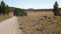
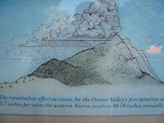
Over the pass, the environs illustrate the rain shadow effect that renders Nevada so dry. Thick fir forests have given way to sparse groupings of pine. Sage invades the bottomlands where modern-day ranchers continue carrying the cudgel first borne by those who chose not to seek silver in the Comstock. The road traces ridges that afford views of flats and valleys named Kyburz, Sardine and Stampede.
The final four miles is an uncomfortable (at least on a motorbike) descent along a twisting road covered in golf-ball sized rocks down a tributary canyon of the Truckee. Reward for this is dusty adventure is a few minutes in a delightful river park in Verdi, Nevada with manicured lawns and access for kayaking, trout fishing or just reflection.
Resources:
http://www.ncgold.com/Museums_Parks/syrp/henness.html “Nevada County Gold” blogs about parks and recreation in the South Yuba drainage.
http://www.ghosttownexplorers.org/henness.htm “Ghost Town Explorers” provides direction to many historic places otherwise passed by. A nice link!
© 2010
Church of the Open Road Press
Note: The following graphic provides information on the “rain shadow” effect that the uplifted Sierra affords lands to the east. This graphic regards the area around the Owens Valley and is posted in the park at Independence, CA, but explains nicely why things are the way things are.


I love your blog. Although I don't ride a motorcycle, I enjoy going out on the open road in my car and exploring. Henness Pass is definitely on my list to do ... I tried doing it this week in my Subaru but discovered quickly that the beginning of the road (I was in Verdi) quickly became bumpy and I thought better of taking my car on it. Some time in the future, I plan on renting a Jeep or SUV and doing the whole length.
ReplyDeleteI'm thinking a Subaru might be in my future - once I get tired of picking up downed motorcycles from gravelly roads. Been looking at various small SUVs and always come back to the Sube...
DeleteThanks for your kinds words about the blog...
What is the clearance of the road? Would a Forrester make it?
DeleteGreat blog
We now have a Forester - 2015. And. yep. I wouldn't hesitate to tackle Henness pass Road with it.
Delete