STATE ROUTE 49 – NEVADA CITY TO SIERRA VALLEY
“The only thing better than a 500-mile day
is two 250-mile days.”
Donya Carlson – Rider Magazine
 |
| Click - or maybe double-click - on any picture. Some will enlarge. Not this one, however.) |
I SOMETIMES SUSPECT GOD made the Sierra Nevada simply so S/He could test humankind’s mettle. There’s very little evidence that the Utes on the east side did much trade with the Maidu on the west. The Donner Party tried to cross ‘em. As did the Big Four. History is littered with tales of those who attempted to tame the mountains and failed.
Eventually, however, engineering won out. Rails cross the Sierra in a couple of places and highways, a couple more.
A classic route is the portion of State Route 49 which heads north out of Grass Valley/Nevada City, finds the North Fork of the Yuba River and follows it to its headwaters on Yuba Pass. From there, 49 winds down to the bucolic Sierra Valley and off toward Vinton.
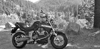
I try to make this ride twice or three times a year. Today’s ride would be on the new-to-me 2007 Moto Guzzi Breva. I needed to see how I’d handle a 200-plus mile day on her and I needed to figure out why she wouldn’t start from time to time - especially if I'd been riding her a while. Today was a day that, if I got stranded, I could work it out.
THE ROUTE NORTH out of Nevada City is nicely sculpted into the South Yuba and over San Juan Ridge. Trails explore mixed woodlands, venturing down to the river when bathers swim, picnic and imbibe. Closer to Downieville, the Indian Valley provides camping and picnicking spots along the free flowing North Yuba. The mining heritage is never far from mind. Place names and roads are linked to the homelands of those who came west.
DOWNIEVILLE IS A CLASSIC mining community struggling to stay viable in a time when dredging is restricted; timber sales are limited and tourism dollars tight. The bell tower serves as a center point to town, screaming "time for lunch" each noon. Belle Tauer also serves as the gossip columnist for the local weekly newspaper, "The Mountain Messenger."
A stroll through town offers several glances over history’s shoulder. Near the public restrooms, rusted relics look a bit like metallic dinosaurs. Of particular interest is a Pelton wheel. The Pelton wheel was invented just over the ridge in North San Juan. Shooting a stream of water into its iron cups, the machine turned harnessing the power that eventually industrialized the mining process in California. Samples can be found in museum yards throughout the gold country. (Note the pulley to the left of the photo, over which a woven belt was looped conveying power to stamping mills and other preposterous rigs.)
Less industrial was the manner in which justice was administered back in the day. The local pizza place is called “The Gallows,” and not without cause. Adjacent to the county courthouse, a noose appears ready for business (unlike the only grocery in town which is currently closed while the new owner renovates.)
Downieville blossomed at the confluence of the Downie and North Yuba Rivers. Highway 49 is reduced to one lane where it crosses, prompting passers-through to wait for the on-coming traffic and perhaps be greeted by one of the community’s friendly denizens.
TWELVE MILES FURTHER ON, Sierra City is a string of antique structures built on either side of 49.
The rush of the North Yuba provides soundtrack as one visits the art gallery or the mercantile. A nice selection of wine waits inside and must be tempting to those who journey the Pacific Crest Trail, which crosses nearby.
Prior to the advent of internal combustion, those who did not walk or slog a mule across, passed this way via stage – the stage being the bearer of passengers, mail, goods and the loot from which it was regularly relieved. The poet, Black Bart, I’m told, may have worked these hills.
BEYOND SIERRA CITY, the road gains elevation. The canyon narrows. Waterfalls lace the area. The mist from their cascade cools the area and provides microclimate for flowers not seen only a few hundred feet either way from the stream.
A Leopard Lily poses nearby.
AT BASSETTS (rooms, café, sundries and
expensive gas) the Lakes Basin Highway splits off to the north. This nicely maintained county / forest service road affords magnificent views of the alp-like Sierra Buttes. Tiny secondary roads – some paved some not –
...wind past the area’s lakes…
…and up to the highest ridges. There is a top-of-the-world feeling when I rest the bike on the side-stand and see nothing but peaked horizon for 360 degrees. This is where the ignition system crapped out, so basking in this Sierran glory, I remove the seat, fiddle with the leads coming off the battery and the wiring harness that powers the-way-too-much electronic gadgetry of the Breva, eventually getting a buzz and a restart. I think I know what to tell the service guy when I take it in.
THE LAKES BASIN HIGHWAY joins State Route 89 just south of Graeagle. A left turn takes me to the chiliburger I’d been craving for a while. Then, heading south on 89, I pass through high mountain meadows and stands of yellow pine, turning left (back on 49) at the rusting teepee burner…
…to head west over Yuba Pass. I stop and take in my annual view of the Sierra Valley and think about how things have evolved over time. The miners are gone. The timber men, too, essentially. Down in the valley, ranchers grow hay and raise cattle and eek out an existence in country too beautiful for words. I can’t help but admire these folks and, at the same time, be a little bit jealous of them.
THE BREVA WAS AN ABSOLUTE HOOT throughout the day. 250 miles did not seem like over-doing it. I have identified the gremlin, I think, and look forward to many more crossings of the Sierra.
© 2011
Church of the Open Road Press


A Wild Goose contributor from Eastern Washington comments:
ReplyDeleteYup, great riding area... Previously lived up near Auburn myself.. Treat yourself on Iowa Hill road to the 80, Mosquito Ridge, etc... lots of great roads and memories.
Would this be the Iowa Hill in question? http://thechurchoftheopenroad.blogspot.com/2009/11/iowa-hill-road-to-colfax.html
ReplyDeleteA Pashnit reader suggests:
ReplyDeleteI guess that was a good ride report. Tho' I thought it had too many words and not enough pictures. They say a picture is worth a lot of words. I didn't read all the words.
And some of the picture were small. Tho' some did get bigger when I clicked on them (not all, tho').
But it was interesting to me as I just went thru' there myself, up 49 from Yosemite, and out to Downieville, then east down to Truckee. Then back and forth thru' all the Sierra passes.
I think definitely Downieville was my favorite out there. And the ride to and from, as it winds along the river.
But Nevada City and Sonora are nice also. I like the use, and reuse of the old buildings. But they both are a little too popular.
Downieville, way off the beaten track, had people there, but wasn't too crowded.
The mission of the Church of the Open Road is to provide:
ReplyDeleteNarratives about motorcycling on Northern California's back roads; Reflections on the history and geography of the North State; Memoirs and early recollections of youthful visits to towns and forests and mountaintops. Also middle-of-the-road takes on current issues in politics and education. Middle of the road? Isn't that dangerous?
Occasionally, there will be pictures.