fabulous Klamath Country adventure
October finds Seattle-based riding buddy connecting with California-based me for an annual ride. Favorite haunts include Eureka’s Eureka Inn
and McCloud’s McCloud Hotel. This year, we’d partake of both – and the roads in between.
…pleasant wharf…
and multiple dining options.
California’s State Route 299 is the northernmost major thoroughfare between the coast and the Sacramento Valley. Well-maintained, this delicious route winds from sea-level marshes and meadows just north of Eureka, tunneling through redwood groves and over the southernmost ridges of the Trinity Mountains, past mining towns oft-overlooked when studying California’s Gold Rush, into oak woodlands finally arriving at Redding. Fairly heavily traveled, it is still a good introduction to the rugged and remote Klamath area of northwestern California.

Better still, however, is California’s State Route 96 that splits north from 299 at Willow Creek first following the Trinity River, then the Klamath which it traces some 140 miles east to Yreka and beyond. Winding through bergs offering no gas (fill up in Willow Creek) and little eats (fill up in Willow Creek), the ride becomes an exploration of the rugged environs that somehow supported five of the least-known tribes in all of the state – until demon gold was discovered in the sands and silt of the riverbed.
Vast numbers of the native population died within the first five years of contact with Europeans. It took a bit longer, but many of the gold-era settlements have fallen into the little-known category as well. We stopped for a calzone in Happy Camp, after about two hours, at the first eatery we would find along the route.
Highway 96 heads east following the Klamath past post offices of place names whose claims to fame have long since gone bust. But the road is built for touring and we find we’ve left the lush coastal landscape behind to be replaced by grasses and stunted chaparral dotting rocky canyon walls.
A detour over to Siskiyou County’s Living Memorial Sculpture Garden
Only eleven miles north of Weed on US 97 and under the watchful gaze of Mount Shasta, queen of the north country, this stark and beautiful park invites pause and reflection.
An overnight at the historic McCloud Hotel https://mccloudhotel.com is restful and comfortable. Breakfast is filling. And a morning stroll around town before mounting the bikes is always in order.
Riding pal departs north as responsibilities called him home – responsibilities a retired guy, such as myself, can only vaguely recall. Thus, I embark on a solo adventure which starts at the Stewarts Springs exit from I-5 north of Weed.
Shifting from county-maintained to Forest Road 17, the pavement narrows.
Rising from the hayfields of the Shasta Valley an over-the-shoulder glance offers a view of the queen cloaked in an early autumn mist, her crystalline peak sparkling just above the cloud.
At FR17’s summit, I cross the Pacific Crest Trail for the first of three times this day.
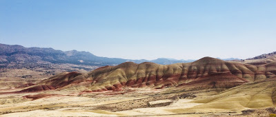
The view to the west recalls the uncertainty with which I tried to explain the Trinity Alps and the Marble Mountains to my fourth graders 35 years ago. The Coast Range was easy: ridge upon ridge folded and bent by the eons-long collision of the North American and Pacific tectonic plates. The Sierra, too: a massive granitic fault block tilted from a fissure on the Nevada side of the range. The Central Valley’s fertile loam and the Mojave Desert’s dryness equally easy.
 |
| Expand this image by clicking on it. |
But, the mountains of Northwestern California – a combination of faults and volcanism and ice and erosion – were harder to define to little kids. “You just have to see ‘em,” I’d said.
The road I was on would snake ten or more miles down to trace a remote stretch of the Trinity River. Rock strewn and narrow, I hadn’t seen nuttin’ yet.
My forest route ended at State Route 3. Turning right (north) twelve well-paved but twisty-downshift-to-first miles would lead me to Callahan. There, there is a small store and bar and there, the skies opened up.
Rather than dismount – although I should have – I relied upon my KLIM riding gear to keep me cocooned in Gore-Tex and dry. https://www.klim.com/Latitude-Jacket-5146-002 This would be the first test of the rather pricy outfit’s weather-proof-ness. It did not fail. Money well spent because as it would turn out, most of the rest of the day would be ridden in showers.
The Callahan-Cecilville Road is yet another of those routes that gets lost in the folds and rises of the Trinities. Nicely banked and paved at the beginning, it’s all just a ruse. Soon I find myself coursing under the fall colors of black oaks, following this stream and that, climbing over ridges and rises I cannot name while hoping in the ability of my Bridgestone tires to navigate chuck-holed and drenched pavement.
Around a bend I splice a pretty good pile of horse poop and then find the offending equine standing on the shoulder of the road. With several pals. I’d arrived at Cecilville where pastureland, front lawns and thoroughfares are not cordoned from one another by fences and where the only business I was interested in open four days out of the week and this wouldn’t be one of those days. I purchased a bubble water and a Slim Jim from the self-service frig in front of the shuttered bar. Why no pictures?
From Cecilville to Forks of Salmon, the road clings to the side of the canyon wall. Why no pictures here? Because there is no wide spot to stop on this one-lane-width of busted pavement where I wouldn’t be at grave risk of obliteration by someone rounding a blind curve. That, or pushed off the 125-foot cliff where today’s rains would rise the river and carry my carcass away downstream to the nearest log jam. Though slow, the ride is stunning and – all the while – reminding me why they call this big Yamaha an “Adventure Tourer.”
At Forks, I run into the improbable: A teacher and a bunch of 10-to-12-year-old students from Bend, Oregon riding bicycles and discovering first-hand those elements of the Trinities that I could not find the words to describe to my students so long ago.
I suspect they’ll do just fine on their standardized test coming up this spring.
Forks of Salmon – where horses, too, roam the streets and front lawns – is a pretty long way from anywhere and that long way continues to involve a narrow, rock-strewn, paved single-lane somehow hung on the canyon wall.
I grip tightly, drive slowly, contemplate any missed curve with dread and finally, after about 2 hours of thirty mile-per-hour bliss and distress, wind up at State Route 96 where I retrace my steps back to Hoopa, 299…
…101 and the comforts of the Eureka Inn.
That evening, over a dram of Whistle Pig, I think about the hearty souls that populate Cecilville and Forks and the deep canyons of the Salmon River, how rugged and independent these folk must be and how similar they are to the sourdoughs and gold seekers of 150 years back. Or, for that matter, the Hupa, the Chilula, the Karok, or the Wintu – all inhabitants of the Klamath region for so many centuries before.
Dropping off into feathered slumber, I have to admit to myself that while I like a good adventure ride, I’m really not all that tough.
© 2018
Church of the Open Road Press


