Tuesday, October 27, 2015

THE BONE-DRY REACHES OF LAKE PILLSBURY


The Sunday edition of the local paper bore a front-page picture of elk grazing in what would be Lake Pillsbury, had there been water.  A trip to that Coast Range locale had long been on my bucket list and Monday’s calendar page was blank.

First – A Little History.  Lake Pillsbury is the second of only two reservoirs on the Eel River.  The first, Lake Van Arsdale, was constructed in Potter Valley (1906) with the intent of diverting Eel River water through a mile-long tunnel to a powerhouse on the Russian River.  This would supply electricity to a growing Ukiah, California, and provide additional water to the growing Russian River Valley.  The Eel River salmon population did not get a vote in this project, suffering due to the Eel’s depleted flow.  Lake Pillsbury was formed by the construction of Scott Dam (1921) to store water in order to provide a more consistent flow down to Van Arsdale and the hydro plant there.  The storage of cold water at Pillsbury and its diversion down the Russian proved to be another blow to the salmon population.

Today’s Trip involved the pickup rather than the motorcycle because the quick fix on my throttle hand apparently isn’t all that quick a fix.  The good news is that Edward, the loyal lab-mix, is able to explore with me.  (He’s such a good boy.)

Exiting state route 20 about eight miles east of US 101, we course our way into the bucolic Potter Valley.  A light tule fog clings to the valley floor cloaking ranch houses and barns in blanket of gray.

Just south of the Van Arsdale powerhouse, a directional sign points us to Lake Pillsbury some 14 miles away.  The road swings east climbing over the shoulder of Middle Mountain as it follow, at a distance, the Eel River.   
The deep canyon and thick pine forest are reminiscent of similar spectacular stream courses sixty miles east in the Sierra.  Except these are little visited.  Quiet.  Perhaps a bit more pristine.

The pavement ends and the well-used route is heavily washboarded this late in the season.  The ride would have been more comfortable on a dual sport bike like a GS or a Stelvio rather than chattering along in the Nissan Frontier.   

After about seven miles, we cross into Lake County.

An intersection near the lake finds us again on pavement.  Right (south) leads to Upper Lake, California.  Left heads over a small ridge dropping us into the basin inundated in normal years by Scott Dam.


But this and the previous three years have been anything but normal.

Though gated and locked, we pull off the road at a campground.

The view of the lakebed calls to mind the high mountain meadows of the southern cascades in Plumas County – my old stompin’ grounds.  Many of those meadows were also inundated becoming reservoirs for a growing California.

A few hundred yards distant graze the elk made famous in the Sunday paper’s photo.

They see (or smell) us, and begin to migrate away.

Reflections from the low sun glimmer off the dead pool perhaps a mile to the south.  My Panasonic Lumix’s telephoto capabilities fool us when it comes to estimating distance.

Breaking off a small embankment, we hike the dry lakebed seeking what might be left of the pool.

The ground is parched and cracked.  Plant life makes is appear as if this part of the basin hasn’t flooded in more than a year.

One of several derelict buoys warns us about creating wake.

One of several boat slips rests on the lakebed bringing new meaning to the term “dry dock.”

That dead pool is further away than I want to go so we turn back toward the campground.   

A curious cow has ventured a bit nearer to us than the rest of the herd, but is soon called – or frightened – back.

Before leaving the area, we check out the Lake Pillsbury Resort.  Lake Pillsbury is fronted by both public and private land.  The resort is private, neatly kept, but apparently closed this day.


We opt to return home via Forest Road M-1, which leads us down White Rock Canyon to the community of Upper Lake and state route 20.  There’s a ten mile section of nicely graded dirt followed by a paved three mile descent involving close to twenty hairpin turns.  Edward, the lab-mix, is not happy with the back and forth.  I wish, at this point, that I had ridden the Guzzi. 28 miles south of Scott's Dam, we have descended into a valley of walnut orchards and vineyards and then onto the tiny antique row that is Upper Lake.

The Lake Pillsbury basin is shallow and should fill nicely after a season of average or better rainfall.  It is a place worth revisiting.  And the several roads that spoke away from the lake up the furthest reaches of the Eel River and past promontories like Snow Mountain (the Coast Range’s highest point) mean the bucket list has simply gotten longer.

o0o

An “OH! MY!” Moment:  Every good trip has at least one moment that takes your breath away: a surprise or a view or an incident that you wish you could capture on film or video but somehow can’t.  Today’s was different. 

Resting about fifteen feet off of Potter Valley road, still frothing, was the carcass of a bull elk.  Why it lay there dead or dying, I cannot imagine.  A vehicle had not struck it or the vehicle would have been disabled as well.  Perhaps it had been shot.  The fog was pretty intense, and the curve a bit blind, so the best I could do was utter: “Oh!  My!”

o0o

Resources: 

A little history (from a so-so source): https://en.wikipedia.org/wiki/Lake_Pillsbury

About Lake Pillsbury Resort: http://lakepillsburyresort.com/


© 2015
Church of the Open Road Press

Saturday, October 17, 2015

REDWOOD ADVENTURE: CHAMBERLAIN CREEK WATERFALL TRAIL


In the Jackson State Demonstration Forest

It used to take forever to get from Willits to Fort Bragg on CA 20.  As a kid, that was the last leg of our twice-yearly trips from Chico to the coast, and the thirty-three miles indicated on the map seem to consume a half a day.  That’s because, as a kid, I was only interested in getting to the ocean – and shopping at the five and dime on Franklin Street.

Now, while I still enjoy the whisper of the surf and dinner at Noyo, the means to the end are becoming more intriguing and worthy of pause.

Looking for a place to walk Edward the lab-mix off leash, I stumbled across a web link to the Jackson State Demonstration Forest.  (See notes below.) At mile marker 17.3 on CA 20, a well-graded dirt road (number 200) follows Chamberlain Creek leading north into the redwoods.  I’ve probably passed this intersection a hundred times.  Road 200 winds along creek-canyon walls and through groves of redwoods.  Were it not gated about six miles in, one could follow it all the way to the California Western right-of-way near North Spur.  When dry, the road is easily passable on a road-oriented motorcycle, but logging operations are active from time to time, so use caution.


The trailhead to Chamberlain Falls is about four miles in on road 200.  There is ample room for parking.  A well-maintained trail descends steeply down the canyon wall, at some points using wooden steps to ensure the safety of the visitor. 

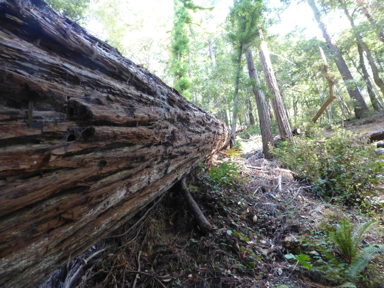
Crossing a downed forest behemoth, we quickly find the creek bottom and, looking over our shoulder worry about the stiff climb out.

But not for long.  There is something in the chorus of silence in a redwood grove that dissolves worry.  Soon we are marveling at the light filtering through the centuries-old trees and thinking about the lucky elves who must enjoy these environs around dusk when no one is present to hear their giggles.

We know they’re here, because we see their houses.


Chamberlain Falls, after four years of sub-normal rainfall, still soldiers on valiantly against the drought.  Looking only as a mere damp section on a solid rock face, one can only imagine the volume of its cascade and accompanying song in a more normal circumstance. 

Exploration is easy because the forest floor is a clear understory, with the exception of the many large trees that lay like God’s Pick-Up-Stix in and around still-established survivors. 

At over six feet tall myself, I estimate the circumference of one giant by standing next to it…

…while Edward explores its length.  He’s happy.

Fears about the steep climb out of this idyllic place are allayed as we encounter a nicely groomed trail that switchbacks up the canyon-side of a tributary, looping back to the road while affording generous views of the enchanting elf-encampment below. 

After forty minutes and about 3.3 total miles (.5 of which are on Road 200) we return to the parking area – refreshed, renewed and excited about what other subtle treasures might be hidden along side the once-interminable highway 20 between Willits and Fort Bragg.

We head home looking forward to more explorations along this route.

o0o

Notes: 

Today’s Route:  US 101 to Willits; west on CA 20 17.3 mile to (unmarked) Road 200; north on 200.  (Landmark: a rest area is on CA 20 is located about 50 yards west and just across the Chamberlain Creek Bridge from the necessary turn-off.)  Follow Road 200 four to four-and-a-half miles to well-marked trailhead on left.  Return:  For a dose of the coast, continue west on CA 20.  Fort Bragg and CA 1 is 18 miles away; south on 1 (along scenic bluffs and through quaint villages) to CA 128 at the mouth of the Navarro River.  East on 128 (through redwoods, wineries and once-funky Boonville) to US 101.

Information on the Jackson State Demonstration Forest from “Mendocino Walks:” http://mendowalks.org/JSDF/JSDF.php


About the Skunk Train (on the old California Western right-of-way): http://www.skunktrain.com/about.html


© 2015
Church of the Open Road Press

Thursday, September 17, 2015

THERAPY RIDE


Five weeks out…

The first good rain of the season came yesterday and everybody knows how good it smells the day after a rain.  The dry grass lays down and emits a glorious, sweet aroma.  Puffy white fair weather clouds dance across the sky, sometimes clinging to the tops of hills like whipped topping on a deep purple mocha.  All the dust and smog and smoke from nearby fires is knocked out of the air and all the roads all appear to be leading to Eden. 

It’d had been nearly five weeks since I’d gone in for surgery on my little finger.  Recovery from that trauma reminds me that joints in guys my age provide ample venues for arthritis to invade.  Not only is that gimpy finger stove up, so is the whole damned hand.  Perhaps a short spin on a lovely day will loosen things up a bit.  Maybe the vibration from the Guzzi’s throttle will be like a gentle massage.  Plus: the weather's so nice.


A favored short loop runs north on US 101 to Hopland, west-southwest on Mountain House Road and east on CA 128 back to Cloverdale.  The route includes both freeway speed and twisting turns against a backdrop of vineyards, open range, oak studded hillsides and historic barns and bridges.  The perfect route for a slightly rusty rider.

South of Hopland, the old 101 is now called River Road.  It traces the eastern side of the Sanel Valley through a canopy of oaks.  Cattle graze the hillside and pears grow in the bottomland.  Its two lanes are bucolic, superior to the nearby US route.

At the Campovida Winery (nice tasting room, wonderful gardens, superb wines) River Road intersects CA 175: closed to the east due to fire this day.  A jog west crosses the Russian River and puts me back in Hopland just south of the Bluebird Café (funky, homey, filling breakfasts; you’ll be treated like a regular).  Heading south on 101 for about a block, a right turn places me on Mountain House Road.  A mile on is the Terra Savia winery and olive oil mill (try the Meritage and pick up some Meyer Lemon Olive Oil.)

I’m out of Hopland almost as soon as I enter.  Mountain House Road is marginally maintained.  It’s easy to go slow and enjoy the rolling hills of the Coast Range.  Here, I find out that the Moto Guzzi massage-therapy theory I’d been operating on is, in reality, not so therapeutic.  My game hand didn’t appreciate having to maintain a consistent grip on the throttle while jarring across hummocky, broken pavement.

I stop ostensibly for some photos, flexing that out-of-shape hand.  The Spanish moss looks rejuvenated in the rains from yesterday.  The chill that had accompanied the front prompts colors to change on some of the area’s black oaks.

Crossing the historic Mountain House Road Bridge, I wonder if this road preceded River Road as the major north-south route 100 years ago.

Ten miles southish, I intersect with CA 128.  A right hand turn would take me 58 miles through wine country and redwoods out to the glorious Mendocino Coast.  But a left takes me eight corkscrew miles back to toward Cloverdale.  I elect to head back to the barn.  Sporting as the Moto Guzzi Breva is, my confidence has ebbed a bit; I pull to the side to allow an Audi to pass, receiving a courtesy wave in response. 

A warm water soak on my hand, once home, loosens things up enough that I can type.  I’ll try this again in a week or two…

© 2015
Church of the Open Road Press

Sunday, September 6, 2015

A LITTLE FINGER SURGERY FOLLOW-UP


Backstory:  What is Dupuytren’s Contracture?  In older men of northern European extraction (I have to cop to at least two of these three characteristics), oft times the fascia overlaying and protecting the tendons which allow the fingers to flex and/or straighten, shrinks up – contracts – disallowing the tendons to do their job. Most commonly, this condition arises on the little finger and, secondarily, the ring finger.  In my case, I found that I could no longer straighten my pinkie.  Repair involved the surgical removal of a section of the uncooperative protective tissue.

A follow up appointment was scheduled three weeks after surgery.  Upon rising that morning, I removed the bandage, showered – the thing could now get washed and dried according to the medicos – and, before rewrapping it, decided to brew a little coffee, sit out on the back porch, let the thing air out and enjoy a little morning sunshine.  (The gauze wrapper really dries and chafes the skin and any moments without that irritant are pleasant ones.)
           
Sipping my Joe, I inspected the wound.  Last week, just after the sutures were removed, it looked like I’d engaged in a pitched a battle with Hannibal Lector and nearly lost.  This week not so bad, things seemed to be knitting nicely.  Lifting the coffee mug with my gimpy hand, a ray of sunshine glanced across the incision.  Shocked, I observed that portions of the scabbing wound near the tip of my little finger were purple – or for Crayola Crayon aficionados: blue-violet.  Purple-blue-violet!  Yikes!
           
Gobsmacked, I nearly dropped my coffee cup onto the glass table.  I stood up to get some better sunlight on it.  Yep!  The damned thing was etched in a sickly bright purple-blue-violet color.  And was that the beginning of some white – I don’t know – a moldy looking fuzz covering the colorful wound?
           
I shared my concern with wife, Candace, who, with a slightly twisted look of concern – no, more like horror – backed away for a moment.
           
Should I call and ask about this?  Or should I wait until my 3:00 PM with the physician’s assistant?  Mulling for some time, I decided that the circumstance couldn’t get much worse in the intervening five hours.  I resumed with my French Roast and read a cover story in the local paper about a dog that died suddenly after swimming in the Russian River where there were blooms of a mysterious blue-green algae.  We’d been out to the Russian River just yesterday.  I reconsidered calling the doc, but didn’t.
           
Rebandaging the finger, I couldn’t help periodically peeking under the gauze roller to see if the purple-blue-violet streak was still purple-blue-violet.  It was during one of those peek-a-boo moments that I noticed the same discoloration at the other end of the work area.  I wondered if it is going to creep across the palm of my hand and up my arm to my elbow.  What’s going on and what might be the fix?  And if they have to amputate my arm, will I have to give up riding the motorcycle?
           
The appointment was only two hours away, so I tried not to fret.  But the fingertip was a little numb and is the joint stiffening up?  Was I going to end up in some sort of a colony?  And what about that flesh-eating mold?

Those two hours passed like molasses in the winter months.  Finally, I sat in the office of the physician’s assistant.  She asked if I had concerns.  I mentioned the discoloration that I’d only seen for the first time this morning.
           
“That’s a skin marker,” she said.  I nodded, not wanting to ask more, assuming that what I was seeing was some chemical or biological reaction that occurred as the traumatized skin worked itself back together.  She added, “The doctor is in the next room.  Let’s have him take a look at it.”
           
My mind immediately flipped back to gangrene or scurvy or Dutch elm disease.
           
The doctor walked in and casually fingered my hand while nodding approval.  “Looks good,” he intoned.
           
“What about this purple-blue-violet?” I asked, trying to subdue the squeakiness in my voice so as to mask my burgeoning panic while pointing to the growing, brightly hued stripes.  (Was it creeping toward my elbow yet?)
           
“Oh that,” he said.  “I take a felt tip pen and outline where we are going to make the incision.  Nothing too precise.  I chose purple Magic Marker to mark your skin.  Somebody’d left the cap off the red one.”
           
“Oh.  A skin marker,” I said.
           
“Yes.  What were you thinking?”
           
“Oh…  Nothing.”

© 2015
Church of the Open Road Press

Monday, August 31, 2015

STELVIO PASS IN THE PALM OF MY HAND


The story of a medical mirage

For folks who like spirited riding on snazzy sport-touring motorcycles, there are Mecca-like roads – a few of them – scattered throughout the world.  In California one might be State Route 36 from Red Bluff to the coast.  In Wyoming and Montana, folks will consider Beartooth Pass.  There’s the Tail of the Dragon back east.   

But the granddaddy of ‘em all is found in the Italian Alps: Stelvio Pass.  Rising 6,138 feet through 75 hairpin turns, the British automotive show Top Gear pegs it as “the greatest driving road in the world.” 

It may or may not remain unchecked on my bucket list.


The summer of 2015 has found me taking a forced hiatus from riding due to a condition called Dupuytren’s Contracture.  
In older men of northern European extraction (I have to cop to at least two of these three characteristics), oft times the fascia which overlays and protects the tendons which allow the fingers to flex and/or straighten, shrinks up – contracts – disallowing the tendons to do their job.  In my case, the crook in my right pinkie made it impossible to put on riding gloves.  ATGATT: No Gloves = No Ride.

Repair for this malady involves removal of a section of the uncooperative fascia.

A very worthy surgeon at my local Kaiser undertook this operation.  When I awoke from anesthesia, my throttle hand was casted and wrapped.  It would remain so for two weeks.  I guess I can go without riding for two weeks, I thought to myself.
Those fourteen days dragged by and when the wraps came off, it turns out that my expectations had been a little vigorous.  It would be at least another two (more than likely four) weeks until my palm fully knitted and I could competently and safely operate a motorcycle.

To add a tiny bit of insult to this injury, it seems the incision necessary for removing the fascia has to be of a zigzag design so as to protect the route of the still working tendon.  I’ve been told to remove the dressing daily to inspect and clean the thing, which I do.  On one of these routine inspections, it struck me:  My surgeon had carved a map of that glorious Italian road right into the palm of my hand!


Thanks Doc!  When I do get over there, I’ll not need GPS to find my way across Stelvio Pass.  But I will have to slip off those gloves.

© 2015
Church of the Open Road Press

Wednesday, August 12, 2015

ALL SMOKE, NO MIRRORS


The Aborted Nor-Cal – Oregon Tour

The idea was simple.  Coordinate with a colleague on his ride north from the Bay Area to his home near Seattle.  Spend a night in Redding, and then head to Bend, Oregon, with a detour around Crater Lake.  Part there and return south, exploring some of the few Southern Oregon and Northern California roads I’d ridden only once, or better yet, only heard about:  OR 62 from Crater Lake along the Rogue River to I-5; CA 3 from Yreka down past Trinity Lake with, perhaps, a side trip out to Ramshorn Summit; Alder Point Road from Bridgeville through Blocksburg and down to Garberville. 

I looked forward to taking pictures of old barns and old bridges and old trucks, pausing at bergs and farmsteads one may fly over yet never see; places where people make a living but it’s not clear how they do (dismissing, perhaps, medicinal herbiculture.)


Fire season in the west, much like the presidential campaign season in the US, never really ends.  Two years ago, a wild fire coughed choking smoke over our home in Sonoma’s Alexander Valley at Thanksgiving.  This year, in mid-July, a wild fire across the ridge in Lake County would grow to over 70,000 acres – 20,000 of them in a three-hour run one Saturday afternoon.  And it wasn’t the first one in the area this go-round.

Meeting up with my riding partner in Winters (after lunch at the incomparable Putah Creek Café) we bolted up Interstate 505 to Dunnigan and I-5 toward the Shasta-Cascade Wonderland hubbed in Redding.  The further north we traveled, the more the blue sky deteriorated into a yellow-gray haze.  He on his Stelvio and I on the GSA, we reveled in being able to legally bat along at 75 mph through the smoky, 100-degree Sacramento Valley. 

At a stop in Orland, we were informed that a bunch of lightning caused blazes were torching the far northern part of the state.  Cal Fire’s central command post was set up at the Shasta County Fairgrounds in Anderson.  Perhaps we could worm our way in and take a look at the current incident map.


“How can I help you fellas?” The Public Information Officer (out of Riverside County) wore a snappy blue uniform – one that looked as if someone engaged in cutting much line hadn’t been wearing it.  The PIO extended a hand and welcomed us with a smile.  Pointing to the incident map, there were, indeed, over seventy active fires within this camp’s sphere, stretching from Del Norte County in the north into Napa and Solano Counties in the south.  It didn’t look good.

The Coast Range had been seared by a wave of dry lightning a few days prior and another wave was forecast to swing north this very evening.

After a gracious forty minute tour of the camp, covering personnel, sleeping arrangements, shifts, the difference between state and federal fire fighting protocols and technical improvements to assist the guys on the line, the PIO concluded:  “You’ll want to get out of Redding early tomorrow in case more of these things blow up.”  He swept his hand over that incident map.

We would hightail it in the morning.


Or would we?

I own a Moto Guzzi: a hoot to ride and, in my 11,000 miles of ownership, bulletproof.  But for longer trips, I take the BMW.  My riding partner’s ride of choice is his ’09 Guzzi Stelvio.  Quirky looking, tank a bit too small for long distance runs, but infused with Italian passione.  He loves the thing.

Unfortunately, some of that passione decided to burst through a blown gasket just beneath the left side cylinder head about fifteen minutes north of Redding that next morning.  The fix may have been simple and the tow to the nearest dealer would be covered by insurance, but the nearest dealer was 194 miles to the south.

The rest of my trip would be solo.


There was no reason for me to continue to Bend so I retraced steps to Redding.  The fire incident map had indicated that CA 3 from Yreka was closed south of Hayfork due to wildfire.  Alder Point road was closed at CA 36 at Bridgeville due to wildfire, which proved a moot point since I wasn’t going to be able to get to 36 via 3.

Recalling that incident map, I knew CA 299 was one of the few roads traversing the Coast Range that would not be closed by fire activity.  I opted to take it from Redding through Weaverville to Arcata on the Humboldt County coast. 

A 30-minute roadwork delay afforded the opportunity to visit with a distance running coach from Utah State U. and a young couple from Iowa – both parties concerned about the area’s thin pall of smoke.  “Unseasonable smoke is pretty common this time of year,” I said.

Beyond Weaverville, CA 299 crests at Oregon Mountain Summit and descends into the Trinity River drainage.  On a normal day, the view from that high point prompts the rider’s pulse to quicken in anticipation of a nicely paved highway twisting in and out of forests, through rustic, tiny villages and along a delightfully tumbling wild river.

Today?  Only smoke.

In cool mornings through early afternoons, airborne particulates settle into lowlands, valleys and canyons.  As the day warms, the smoke rises and dissipates.  The day hadn’t warmed yet.

The further west I drove, the thicker the smoke became to the point that, if there were city blocks in the area, you couldn’t see further than two of ‘em.  I stopped for a picture near Burnt Ranch wondering if they might rename the place “Reburnt” or “Twice Burnt” Ranch by the time these conflagrations played out.


Near Blue Lake, now following the Mad River, the valley opens to the sea.  On-shore breezes mercifully pushed against the burgeoning blanket of smoke.  Thus, the air was a clear and lovely azure.  Deep breaths yielded only freshness, no cinders.   

The ride south on US 101 into Eureka emphasized just how strongly that cross wind, on-shore breeze can blow.

A quick shower to rid myself of soot.  Dinner near the historic wharf, followed by an evening walk along the waterfront, then a night’s rest at the Eureka Inn.


Morning of the final day dawned gray and drizzly, a pleasant, fresh change from the hot, murky interior. 

South on US 101 and west on CA 1 led me to a crystal view of the Pacific over the rugged Mendocino coast. 

Dubbed the Shoreline Highway, California’s State Route 1 is one motorcyclists, worldwide, come to experience this most entertaining road. 

Along the way, riders enjoy quaint fishing villages, stately redwood stands, inviting strolls to the bluffs and views that reach beyond forever.   

I dawdled in the clean maritime air, and stopped for a plate of clams at Noyo.

Ninety minutes inland and I would be home.


Whether this loop at this time could be categorized as a great trip, I’d have to offer doubts, given the conditions.  But all in all, it was an excellent experience; just one I’d rather not repeat any time soon.

© 2015
Church of the Open Road Press

Sunday, August 9, 2015

THE HONDA I DIDN’T GET


Early 1970s – After about two years on my Honda 90, it was time for me to graduate into something larger.  A buddy of mine named John had been tooling around on a Honda 55 and was confronted with the same angst.

Living in Chico, on Sunday mornings only, we received the Sacramento Bee delivered to the end of our long gravel drive.  Perusing the want ad section as I had for months, one Sunday I came across a display ad from Spinetti’s Hardware (an authorized Honda motorcycle dealer) in far off Jackson, California.  It was the year that Honda had changed the tank on their venerable CB 350 from something rectangular to a more rounded shape.  The boxy tank looked better in John’s mind and my own and Spinetti’s was closing out last year’s model for a couple of hundred bucks off.

I alerted John.  “Look, man!  Only $875.00!”  I’d been working a concession stand and John was a lifeguard at the local pool.  We checked our bank balances.  Yep, we could do this.

John had his eye on a blue and white one and I favored the red and white one. 

Our plan was to pull money from savings – actually drain savings – and have John’s dad, John senior, ferry us the 110 miles down to Jackson in his Pontiac station wagon.  There, we’d seal the deal and, just like in “Easy Rider,” ride ‘em back north.

Ever’body’s talkin’ at me, I can’t hear a word they’re sayin’…

Apparently, among the everybody I couldn’t hear was Mom.  On the day of the deal, she put her foot down.  “That money is going to be used for your education.  You’re not going to buy another damned motorcycle!”


John’s dad didn’t need to ferry us down to Jackson.  Instead, we borrowed the Pontiac and drove there ourselves.  John consumated the deal and, wrapping his new CB in a couple of blankets, we slid the bike into the back of the station wagon and drove home.  (Insult to injury?  John bought a red one.)

© 2015
Church of the Open Road Press

Wednesday, August 5, 2015

THE PIANO MAN AND HIS VISIT TO THE DUMP


Dateline:  Healdsburg (CA) dump:  My daughter’s old upright freezer died and I was charged with getting rid of the thing.  With a little research, I find that Sonoma County landfills will recycle old major appliances charging twenty bucks per item if the unit has Freon in it.  All others are free.
           
So I truck it on over to the landfill.  The host waves me through without weighing my vehicle, telling me to see the fellows over in recycle.  “Take a left at the top of the hill.”
           
Recycle is a rich milieu of using building materials, windows, doors, toilets and such along with glass, aluminum and cardboard.  Not immediately seeing appliances in the mix, I pull in looking for someone official willing to take my twenty and give me some direction.
           
I don’t see anybody.  What I do see, however, amid barbecues and dressers and old couches, is a derelict spinet piano, some off brand, standing abandoned and alone, like Bogey at that train station in Paris. (My brother, who moves pianos for a living, says more and more frequently he is taking them to the dump because they are too old to tune and there is no market for them.)  Since everything in life relates in one way or another to a scene from Casablanca, I walk over to the instrument and begin to tickle out a few bars of “As Time Goes By.”
           
Another customer comes up to me, thinking I must work at the place and asks me where he should drop off his old RCA Victor TV.  “I don’t know,” I respond, “I was going to ask you where to put my freezer.”  I turn back to the keyboard and pick up where I’d left off:  Moonlight and love songs…


This incident got me thinking.  What if, on Saturdays, someone pulled a six-hour shift – say, ten to four – at the dump attending to an old junker piano.  He or she could play standards and take requests, perhaps placing a big glass brandy snifter on top of the thing for tips. 
           
Thirty years ago, my old buddy Tom and I used to trek out to the Jamestown landfill with our household garbage about once a month.  We’d look at what folks had discarded and comment on what a cultural experience it was.
           
A piano man would only make a trip to the dump more so.
           
Where are you Billy Joel?

© 2015
Church of the Open Road Press

Saturday, August 1, 2015

THE HOME OWNER


People You Meet on the Road:
Ukiah, California edition

10:00 AM today:  Backing the Moto Guzzi into a space in front of Mendocino Book Company – one of the closer independent booksellers to our new digs – I noticed a gentleman, about my age, pausing before getting into the newish Grand Cherokee in a neighboring slot.  The Jeep had some random building materials tied to its roof rack.

“Man, that’s a beautiful bike,” he said as I killed the engine.  His eyes flashed like those of one anticipating a fine stretch of curves on a perfect summer day.

I gave my pat response: “Better than I deserve.”

He moved closer, staring at the gleaming chrome and polished black paint on my Breva.  “I had a V-65 Lario.  Thing was bulletproof.  Compared to a Ducati?”  He buzzed his lips and shook his head.  “Loved that Guzzi.  Sold it 20 years ago.  Haven’t ridden since.”

I nodded knowingly, though I knew nothing about a ’65 Lario or most any other vintage Guzzis.  “Haven’t ridden since?”  I asked.  “Why?”

“Bought a house.”

[The reader will note that folks who ride (or rode) often speak in phrases, or at best, very short sentences.]

 “Well, we should get you back in the saddle.”  I handed him a Church of the Open Road calling card.

He glanced at the card then returned the bike.  “Love to, but can’t.”

“Why not?” I asked.

“Fixin’ the house,” he said gesturing toward the lumber on top of his Cherokee.

“You been fixin’ your house for twenty years?”

His gaze lowered to the paint stripe separating our vehicles.  “Yep.”  His now-crestfallen voice was nary a whisper.

Eventually, he looked up and, together, we laughed. 

He climbed into the Jeep, backed out and, as he drove off, said, “Some day…”


 © 2015
Church of the Open Road Press