 |
| Clicking on any picture should cause it to expand. Should. |
Traveling east on State Route 49 from Auburn-Downieville toward Yuba Pass, the tiny hamlet of Bassett’s rests in a crook of the North Yuba River canyon. At this point the Lakes Basin highway courses northward through a wonderland of primary and secondary roads, paved and unpaved – but more importantly – some very nicely groomed and little-used hiking trails. These paths connect countless alpine lakes crossing over and between the ridges and peaks of eons-old glaciation.
I drive the little Guzzi up the Lakes Basin Highway a short bit, turning left toward Sardine Lakes. Half mile later a right turn finds me on a nicely paved, narrow strip that rises tantalizingly toward a summit trailhead.
It would be two and a half miles from this point to the stairs that lead to the lookout cemented to the Sierra Buttes at 8800 feet. Those unused muscle groups would get their workout.
FROM THE TRAILHEAD, the goal, the lookout atop the Buttes is readily in view. In fact, as the trail – part of the Pacific Crest – weaves its way south, the lookout is never out of sight for more than a few hundred yards. There is some gratification is seeing the progress one makes when hiking at elevation.
 |
| North and east toward the Cascades |
 |
| Mules Ear |
Indian Paintbrush poke through Manzanita and the Manzanita itself can be found creeping over eons-old chunks of metamorphic effort.
 |
| Prickly phlox |
The PCT gains elevation steadily but gently for the first couple of miles. It is only once I branch off on an old service road that the elevation begins to take a toll. The stands of fir, below, have given way to singular pines and junipers. These give way to only the occasional prickly shrub. Above about 8000 feet the winters are too long and harsh for anything substantial to take root.
ONE OF THE GREATEST THINGS about a fire lookout is that they always seem to have great views.
 |
| Upper and Lower Sardine |
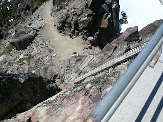
The tower is affixed to a very shear precipice.
 |
| EEEeee-yikes! |
IT TAKES HALF AS LONG to return to the Guzzi as it took to achieve the summit. Muscles that didn’t get a workout on the climb, did get one gingerly threading down the pebbly path.
Straddling the little bike, one finds that first gear is the appropriate choice for safely descending the steep, narrow paved strip back toward Packer and Sardine Lakes.
The ride and the hike make for a full day. And memories that will linger long after the aches and pains of the stout walk have faded.
RESOURCES:
Sierra County Chamber of Commerce: Not as much commerce going on in Sierra County as they would like in these times, but a great overview of the area is located at: http://www.sierracountychamber.com/ Folks up that way deserve our business.
© 2011
Church of the Open Road Press


No comments:
Post a Comment